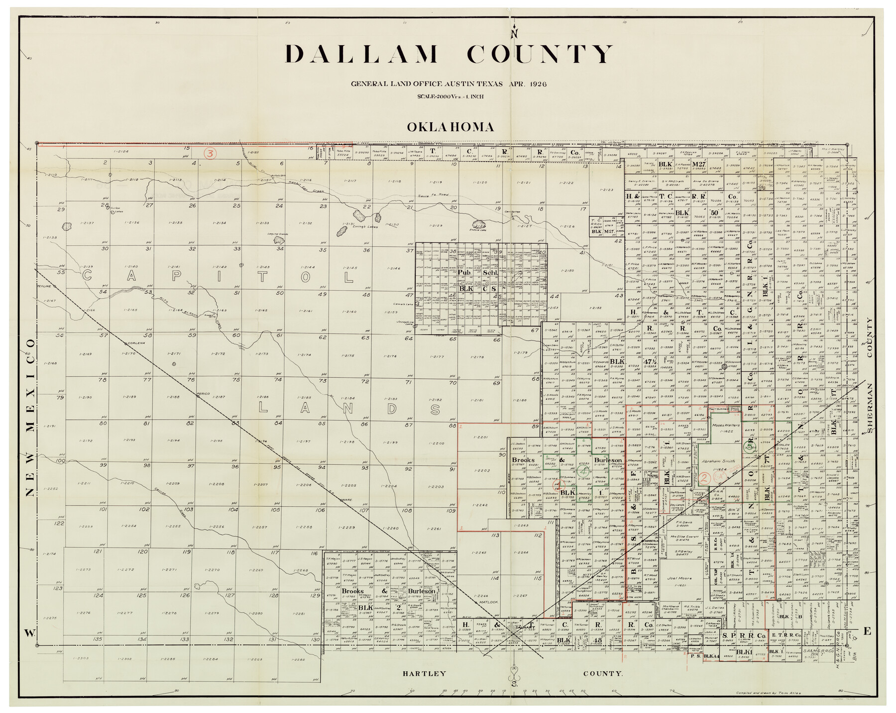
Dallam County Working Sketch Graphic Index
-
Map/Doc
76516
-
Collection
General Map Collection
-
Object Dates
4/1926 (Creation Date)
-
People and Organizations
Tom Atlee (Draftsman)
-
Counties
Dallam
-
Subjects
County Surveying Working Sketch
-
Height x Width
41.3 x 50.9 inches
104.9 x 129.3 cm
-
Scale
1" = 2000 varas
Part of: General Map Collection
Brewster County Working Sketch 32

Print $20.00
- Digital $50.00
Brewster County Working Sketch 32
1943
Size 28.3 x 28.3 inches
Map/Doc 67566
Menard County Working Sketch 31

Print $20.00
- Digital $50.00
Menard County Working Sketch 31
1980
Size 25.6 x 24.5 inches
Map/Doc 70978
Hutchinson County Working Sketch 49

Print $20.00
- Digital $50.00
Hutchinson County Working Sketch 49
1988
Size 35.2 x 37.3 inches
Map/Doc 66409
Treaty to Resolve Pending Boundary Differences and Maintain the Rio Grande and Colorado River as the International Boundary Between the United States of American and Mexico

Print $4.00
- Digital $50.00
Treaty to Resolve Pending Boundary Differences and Maintain the Rio Grande and Colorado River as the International Boundary Between the United States of American and Mexico
1970
Size 12.2 x 19.0 inches
Map/Doc 83100
Refugio County Working Sketch 17

Print $20.00
- Digital $50.00
Refugio County Working Sketch 17
1980
Size 17.7 x 30.1 inches
Map/Doc 63526
Hudspeth County Working Sketch 35

Print $40.00
- Digital $50.00
Hudspeth County Working Sketch 35
Size 37.0 x 55.2 inches
Map/Doc 66320
[Surveys in the Bexar District along the Nueces and Leona Rivers]
![116, [Surveys in the Bexar District along the Nueces and Leona Rivers], General Map Collection](https://historictexasmaps.com/wmedia_w700/maps/116.tif.jpg)
Print $3.00
- Digital $50.00
[Surveys in the Bexar District along the Nueces and Leona Rivers]
1845
Size 10.9 x 14.3 inches
Map/Doc 116
Calhoun County Rolled Sketch 30

Print $20.00
- Digital $50.00
Calhoun County Rolled Sketch 30
1974
Size 18.6 x 27.6 inches
Map/Doc 5491
Jim Hogg County Sketch File 8

Print $20.00
- Digital $50.00
Jim Hogg County Sketch File 8
1941
Size 21.9 x 27.0 inches
Map/Doc 11887
Atlas Pintoresco e Historico de los Estados Unidos Mexicanos

Atlas Pintoresco e Historico de los Estados Unidos Mexicanos
Map/Doc 96796
Galveston County Sketch File 1b

Print $6.00
- Digital $50.00
Galveston County Sketch File 1b
1845
Size 16.2 x 11.0 inches
Map/Doc 23347
La Salle County Rolled Sketch 5

Print $20.00
- Digital $50.00
La Salle County Rolled Sketch 5
1937
Size 17.8 x 27.4 inches
Map/Doc 6570
You may also like
McMullen County Working Sketch 2

Print $20.00
- Digital $50.00
McMullen County Working Sketch 2
1919
Size 30.9 x 19.2 inches
Map/Doc 70703
Jack County Sketch File 5

Print $6.00
- Digital $50.00
Jack County Sketch File 5
1875
Size 11.0 x 10.8 inches
Map/Doc 27508
Coryell County Working Sketch 1

Print $20.00
- Digital $50.00
Coryell County Working Sketch 1
1906
Size 14.7 x 12.9 inches
Map/Doc 68208
Palo Pinto County Working Sketch 9

Print $20.00
- Digital $50.00
Palo Pinto County Working Sketch 9
1922
Map/Doc 71392
Brewster County Rolled Sketch 138

Print $20.00
- Digital $50.00
Brewster County Rolled Sketch 138
1982
Size 24.5 x 38.0 inches
Map/Doc 5306
Liberty County Working Sketch 47

Print $20.00
- Digital $50.00
Liberty County Working Sketch 47
1954
Size 28.3 x 24.6 inches
Map/Doc 70506
Tom Green County Rolled Sketch 6

Print $20.00
- Digital $50.00
Tom Green County Rolled Sketch 6
Size 21.6 x 17.1 inches
Map/Doc 7995
General Highway Map, Kerr County, Texas

Print $20.00
General Highway Map, Kerr County, Texas
1961
Size 24.8 x 18.2 inches
Map/Doc 79551
Hutchinson County Working Sketch 35

Print $20.00
- Digital $50.00
Hutchinson County Working Sketch 35
1978
Size 27.0 x 22.3 inches
Map/Doc 66395
Motley County Sketch File E (S)

Print $52.00
- Digital $50.00
Motley County Sketch File E (S)
Size 14.6 x 9.0 inches
Map/Doc 32169
Goliad County Rolled Sketch 7

Print $69.00
- Digital $50.00
Goliad County Rolled Sketch 7
1849
Size 10.6 x 16.1 inches
Map/Doc 45254
General Chart of the Coast No. XVI - Gulf Coast from Galveston to the Rio Grande

Print $20.00
- Digital $50.00
General Chart of the Coast No. XVI - Gulf Coast from Galveston to the Rio Grande
1883
Size 26.8 x 18.2 inches
Map/Doc 72736