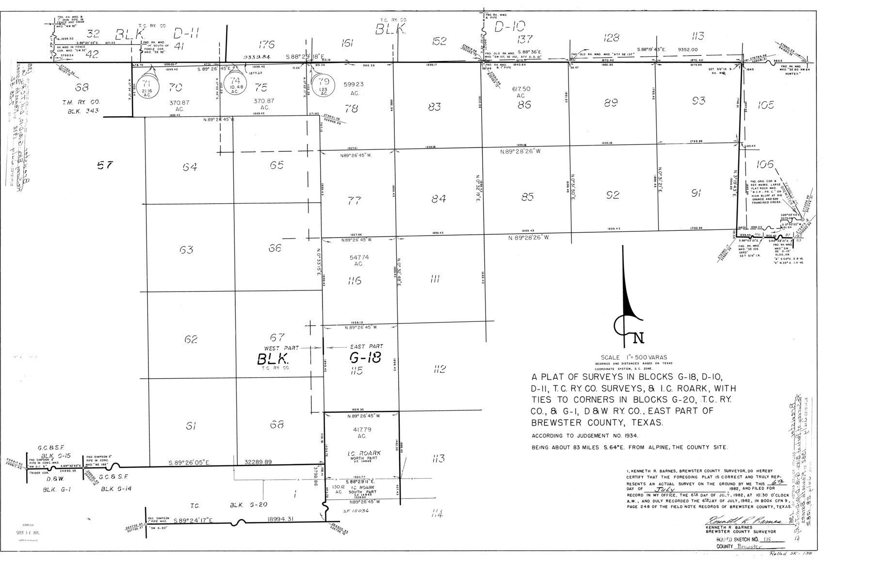
Brewster County Rolled Sketch 138
A plat of surveys in Blocks G-18, D-10, D-11, T. C. Ry. Co. surveys, & I.C. Roark, with ties to corners in Blocks G-20, T. C. Ry. Co. & G-1, D. & W. Ry. Co., east part of Brewster County, Texas according to judgement no. 1934
-
Map/Doc
5306
-
Collection
General Map Collection
-
Object Dates
1982/7/6 (Creation Date)
1982/7/28 (File Date)
-
People and Organizations
Kenneth R. Barnes (Surveyor/Engineer)
-
Counties
Brewster
-
Subjects
Surveying Rolled Sketch
-
Height x Width
24.5 x 38.0 inches
62.2 x 96.5 cm
-
Medium
mylar, print
-
Scale
1" = 500 varas
Part of: General Map Collection
Hunt County Working Sketch 6

Print $20.00
- Digital $50.00
Hunt County Working Sketch 6
1942
Size 31.0 x 40.3 inches
Map/Doc 66353
Bowie County Sketch File 7

Print $40.00
- Digital $50.00
Bowie County Sketch File 7
1927
Size 18.0 x 35.5 inches
Map/Doc 10943
Gonzales County Sketch File 6

Print $4.00
- Digital $50.00
Gonzales County Sketch File 6
1880
Size 10.2 x 8.7 inches
Map/Doc 24385
Right of Way and Track Map, the Missouri, Kansas and Texas Ry. of Texas operated by the Missouri, Kansas and Texas Ry. of Texas, San Antonio Division

Print $40.00
- Digital $50.00
Right of Way and Track Map, the Missouri, Kansas and Texas Ry. of Texas operated by the Missouri, Kansas and Texas Ry. of Texas, San Antonio Division
1918
Size 25.3 x 58.3 inches
Map/Doc 64579
Newton County Rolled Sketch 12

Print $40.00
- Digital $50.00
Newton County Rolled Sketch 12
1952
Size 38.4 x 56.1 inches
Map/Doc 9577
Flight Mission No. BRA-8M, Frame 75, Jefferson County

Print $20.00
- Digital $50.00
Flight Mission No. BRA-8M, Frame 75, Jefferson County
1953
Size 18.6 x 22.4 inches
Map/Doc 85595
Ellis County Working Sketch 2

Print $20.00
- Digital $50.00
Ellis County Working Sketch 2
1947
Size 27.0 x 25.6 inches
Map/Doc 69018
Brewster County Working Sketch 80

Print $20.00
- Digital $50.00
Brewster County Working Sketch 80
1972
Size 44.3 x 39.1 inches
Map/Doc 67680
Jasper County Working Sketch 24

Print $40.00
- Digital $50.00
Jasper County Working Sketch 24
1948
Size 44.2 x 54.9 inches
Map/Doc 69651
Hall County Sketch File 29 and 29a

Print $12.00
- Digital $50.00
Hall County Sketch File 29 and 29a
1913
Size 8.9 x 7.9 inches
Map/Doc 24824
Flight Mission No. DQN-1K, Frame 82, Calhoun County

Print $20.00
- Digital $50.00
Flight Mission No. DQN-1K, Frame 82, Calhoun County
1953
Size 18.5 x 22.2 inches
Map/Doc 84167
Erath County Working Sketch 4

Print $20.00
- Digital $50.00
Erath County Working Sketch 4
1919
Size 31.7 x 28.6 inches
Map/Doc 69085
You may also like
Flight Mission No. CRC-3R, Frame 210, Chambers County

Print $20.00
- Digital $50.00
Flight Mission No. CRC-3R, Frame 210, Chambers County
1956
Size 18.6 x 22.3 inches
Map/Doc 84865
Palo Pinto County

Print $20.00
- Digital $50.00
Palo Pinto County
1896
Size 27.2 x 22.1 inches
Map/Doc 3937
[Gunter & Munson, Maddox Bros. & Anderson Blocks F and A and State University Lands Blocks 15-17 and 50]
![91847, [Gunter & Munson, Maddox Bros. & Anderson Blocks F and A and State University Lands Blocks 15-17 and 50], Twichell Survey Records](https://historictexasmaps.com/wmedia_w700/maps/91847-1.tif.jpg)
Print $20.00
- Digital $50.00
[Gunter & Munson, Maddox Bros. & Anderson Blocks F and A and State University Lands Blocks 15-17 and 50]
1884
Size 12.2 x 16.2 inches
Map/Doc 91847
The Republic County of Goliad. 1840

Print $20.00
The Republic County of Goliad. 1840
2020
Size 15.1 x 21.7 inches
Map/Doc 96150
Refugio County Sketch File 25

Print $6.00
- Digital $50.00
Refugio County Sketch File 25
1915
Size 14.5 x 6.4 inches
Map/Doc 35289
Wichita County Rolled Sketch 15

Print $20.00
- Digital $50.00
Wichita County Rolled Sketch 15
Size 17.0 x 37.1 inches
Map/Doc 8252
Marion County

Print $20.00
- Digital $50.00
Marion County
1943
Size 24.3 x 41.2 inches
Map/Doc 77365
Brewster County Sketch File N-5

Print $6.00
- Digital $50.00
Brewster County Sketch File N-5
Size 12.9 x 8.6 inches
Map/Doc 15605
Webb County Sketch File 60

Print $8.00
- Digital $50.00
Webb County Sketch File 60
1943
Size 14.4 x 8.9 inches
Map/Doc 39855
Flight Mission No. DCL-4C, Frame 66, Kenedy County

Print $20.00
- Digital $50.00
Flight Mission No. DCL-4C, Frame 66, Kenedy County
1943
Size 18.6 x 22.3 inches
Map/Doc 85811
Williamson County Sketch File 4

Print $26.00
- Digital $50.00
Williamson County Sketch File 4
1849
Size 15.9 x 10.4 inches
Map/Doc 40304
Callahan County Sketch File 7

Print $18.00
- Digital $50.00
Callahan County Sketch File 7
Size 10.8 x 8.9 inches
Map/Doc 35863