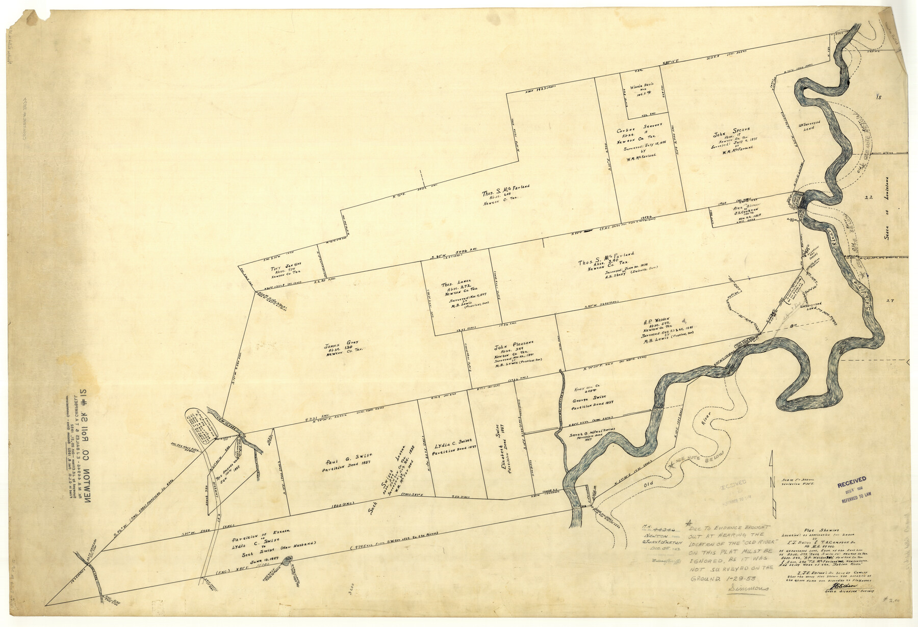
Newton County Rolled Sketch 12
Plat showing location of application for lease by E.J. Bailes & T.A. Campbell, Jr. no. M.A. 44946
-
Map/Doc
9577
-
Collection
General Map Collection
-
Object Dates
1952/10/21 (Creation Date)
1952/12/8 (File Date)
-
People and Organizations
J.E. Ellison (Surveyor/Engineer)
-
Counties
Newton
-
Subjects
Surveying Rolled Sketch
-
Height x Width
38.4 x 56.1 inches
97.5 x 142.5 cm
-
Medium
paper, manuscript
-
Scale
1" = 300 varas
Part of: General Map Collection
Nueces County Sketch File 68

Print $8.00
- Digital $50.00
Nueces County Sketch File 68
Size 11.0 x 8.7 inches
Map/Doc 33000
Colorado County Sketch File 34

Print $86.00
- Digital $50.00
Colorado County Sketch File 34
1996
Size 14.2 x 8.8 inches
Map/Doc 18992
Flight Mission No. BRA-16M, Frame 180, Jefferson County

Print $20.00
- Digital $50.00
Flight Mission No. BRA-16M, Frame 180, Jefferson County
1953
Size 18.5 x 22.4 inches
Map/Doc 85778
Brooks County Rolled Sketch 17

Print $20.00
- Digital $50.00
Brooks County Rolled Sketch 17
1941
Size 30.8 x 36.5 inches
Map/Doc 8532
Kinney County

Print $40.00
- Digital $50.00
Kinney County
1955
Size 48.9 x 42.4 inches
Map/Doc 77342
Kimble County Sketch File 20

Print $8.00
- Digital $50.00
Kimble County Sketch File 20
1892
Size 3.9 x 6.5 inches
Map/Doc 28957
Coryell County

Print $20.00
- Digital $50.00
Coryell County
1936
Size 46.8 x 43.4 inches
Map/Doc 1810
Red River County Working Sketch 27

Print $20.00
- Digital $50.00
Red River County Working Sketch 27
1961
Size 25.3 x 42.7 inches
Map/Doc 72010
Matagorda County NRC Article 33.136 Sketch 4

Print $28.00
- Digital $50.00
Matagorda County NRC Article 33.136 Sketch 4
2008
Size 31.0 x 36.5 inches
Map/Doc 89036
Real County Working Sketch 67

Print $20.00
- Digital $50.00
Real County Working Sketch 67
1970
Size 21.2 x 16.4 inches
Map/Doc 71959
Jack County Sketch File 7

Print $6.00
- Digital $50.00
Jack County Sketch File 7
1857
Size 6.7 x 12.4 inches
Map/Doc 27516
Coleman County Sketch File 50

Print $4.00
- Digital $50.00
Coleman County Sketch File 50
Size 12.6 x 8.2 inches
Map/Doc 18853
You may also like
Webb County Rolled Sketch 71

Print $20.00
- Digital $50.00
Webb County Rolled Sketch 71
Size 24.2 x 18.5 inches
Map/Doc 8218
Fannin County Working Sketch Graphic Index

Print $20.00
- Digital $50.00
Fannin County Working Sketch Graphic Index
1946
Size 41.3 x 36.2 inches
Map/Doc 76540
Crane County Working Sketch 33

Print $20.00
- Digital $50.00
Crane County Working Sketch 33
1985
Size 30.3 x 27.6 inches
Map/Doc 68310
Railroad Track Map, H&TCRRCo., Falls County, Texas

Print $4.00
- Digital $50.00
Railroad Track Map, H&TCRRCo., Falls County, Texas
1918
Size 11.5 x 18.4 inches
Map/Doc 62846
Atascosa County Rolled Sketch 26

Print $20.00
- Digital $50.00
Atascosa County Rolled Sketch 26
2013
Size 24.6 x 36.6 inches
Map/Doc 95409
Bandera County Working Sketch 60

Print $20.00
- Digital $50.00
Bandera County Working Sketch 60
2004
Size 32.1 x 43.6 inches
Map/Doc 83562
Texas City Channel, Texas, Channel and Turning Basin Dredging - Sheet 1

Print $20.00
- Digital $50.00
Texas City Channel, Texas, Channel and Turning Basin Dredging - Sheet 1
1958
Size 29.3 x 40.8 inches
Map/Doc 61831
Chambers County Rolled Sketch 34

Print $40.00
- Digital $50.00
Chambers County Rolled Sketch 34
1956
Size 50.0 x 85.8 inches
Map/Doc 73571
The Republic County of Red River. Boundaries Defined, December 18, 1837

Print $20.00
The Republic County of Red River. Boundaries Defined, December 18, 1837
2020
Size 17.4 x 21.7 inches
Map/Doc 96251
Jones County Sketch File 9

Print $22.00
- Digital $50.00
Jones County Sketch File 9
Size 8.3 x 7.5 inches
Map/Doc 28495
[Block H, Block 24]
![92598, [Block H, Block 24], Twichell Survey Records](https://historictexasmaps.com/wmedia_w700/maps/92598-1.tif.jpg)
Print $20.00
- Digital $50.00
[Block H, Block 24]
Size 30.2 x 17.0 inches
Map/Doc 92598
Grayson County Sketch File 12

Print $4.00
- Digital $50.00
Grayson County Sketch File 12
1853
Size 12.8 x 8.4 inches
Map/Doc 24478