Colorado County Sketch File 34
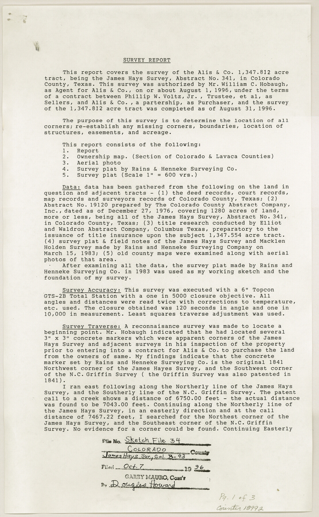
[Survey report regarding resurvey of James Hays, A-341, COL B-43, 1347.812 acres]
-
Map/Doc
18992
-
Collection
General Map Collection
-
Object Dates
1996/8/2 (Creation Date)
1996/10/7 (File Date)
1983/3/15 (Survey Date)
-
People and Organizations
Leonard W. Frank (Surveyor/Engineer)
Rains & Henneke Surveying Company (Surveyor/Engineer)
S. Michael Rains (Surveyor/Engineer)
Marvin W. Koehne (Draftsman)
-
Counties
Colorado Lavaca
-
Subjects
Surveying Sketch File
-
Height x Width
14.2 x 8.8 inches
36.1 x 22.4 cm
-
Medium
multi-page, multi-format
-
Scale
1:600; 1:300
-
Features
West Sandy Creek
Sandies Creek
Oldenrod Creek
Senoras Creek
Part of: General Map Collection
Map of The Surveyed Part of Peters Colony Texas

Print $40.00
- Digital $50.00
Map of The Surveyed Part of Peters Colony Texas
1858
Size 45.6 x 58.5 inches
Map/Doc 1982
Key to Photo Index Sheets of Texas Coast Portion

Print $20.00
- Digital $50.00
Key to Photo Index Sheets of Texas Coast Portion
1954
Size 20.0 x 24.0 inches
Map/Doc 83437
Henderson County Rolled Sketch 11

Print $20.00
- Digital $50.00
Henderson County Rolled Sketch 11
1915
Size 29.1 x 42.4 inches
Map/Doc 75948
Sabine County Sketch File 4

Print $22.00
Sabine County Sketch File 4
1876
Size 8.1 x 12.8 inches
Map/Doc 35606
Pecos County Working Sketch 12

Print $20.00
- Digital $50.00
Pecos County Working Sketch 12
1912
Size 21.3 x 30.0 inches
Map/Doc 71482
Edwards County Sketch File A1

Print $6.00
- Digital $50.00
Edwards County Sketch File A1
Size 8.5 x 8.8 inches
Map/Doc 21659
Van Zandt County Sketch File 14

Print $4.00
- Digital $50.00
Van Zandt County Sketch File 14
1858
Size 7.9 x 8.1 inches
Map/Doc 39404
Map of Wharton County

Print $20.00
- Digital $50.00
Map of Wharton County
1865
Size 24.9 x 26.9 inches
Map/Doc 4136
Bastrop County

Print $40.00
- Digital $50.00
Bastrop County
1917
Size 49.7 x 42.0 inches
Map/Doc 4796
Culberson County Rolled Sketch 27

Print $20.00
- Digital $50.00
Culberson County Rolled Sketch 27
1922
Size 26.8 x 34.9 inches
Map/Doc 5656
Flight Mission No. BQY-15M, Frame 13, Harris County

Print $20.00
- Digital $50.00
Flight Mission No. BQY-15M, Frame 13, Harris County
1953
Size 18.8 x 22.5 inches
Map/Doc 85311
University Lands Blocks 29-33, Crockett County, Texas

Print $20.00
- Digital $50.00
University Lands Blocks 29-33, Crockett County, Texas
Size 29.7 x 44.1 inches
Map/Doc 62943
You may also like
[Area around Runnels County School Land and I. & G. N. Block 1]
![91664, [Area around Runnels County School Land and I. & G. N. Block 1], Twichell Survey Records](https://historictexasmaps.com/wmedia_w700/maps/91664-1.tif.jpg)
Print $20.00
- Digital $50.00
[Area around Runnels County School Land and I. & G. N. Block 1]
Size 23.0 x 17.9 inches
Map/Doc 91664
Working Sketch Cochran and Yoakum Co's.

Print $40.00
- Digital $50.00
Working Sketch Cochran and Yoakum Co's.
1919
Size 54.2 x 14.5 inches
Map/Doc 89678
Yoakum County Rolled Sketch 6

Print $20.00
- Digital $50.00
Yoakum County Rolled Sketch 6
Size 18.7 x 34.6 inches
Map/Doc 8291
Freestone County Working Sketch 2

Print $20.00
- Digital $50.00
Freestone County Working Sketch 2
1913
Size 23.1 x 28.2 inches
Map/Doc 69244
The Mexican Municipality of Mina. Created, April 1834

Print $20.00
The Mexican Municipality of Mina. Created, April 1834
2020
Size 10.7 x 21.7 inches
Map/Doc 96028
Knox County Rolled Sketch 21

Print $20.00
- Digital $50.00
Knox County Rolled Sketch 21
1955
Size 18.0 x 36.4 inches
Map/Doc 6561
Aransas County NRC Article 33.136 Sketch 3

Print $20.00
- Digital $50.00
Aransas County NRC Article 33.136 Sketch 3
2003
Size 25.1 x 36.1 inches
Map/Doc 80138
Pecos County Working Sketch 5

Print $20.00
- Digital $50.00
Pecos County Working Sketch 5
1886
Size 22.8 x 19.2 inches
Map/Doc 71475
[I. & G. N. Block 1 and surroundings]
![91596, [I. & G. N. Block 1 and surroundings], Twichell Survey Records](https://historictexasmaps.com/wmedia_w700/maps/91596-1.tif.jpg)
Print $20.00
- Digital $50.00
[I. & G. N. Block 1 and surroundings]
1892
Size 18.6 x 25.6 inches
Map/Doc 91596
Dimmit County Rolled Sketch 5

Print $20.00
- Digital $50.00
Dimmit County Rolled Sketch 5
1904
Size 42.7 x 18.2 inches
Map/Doc 5715
Flight Mission No. BRA-16M, Frame 165, Jefferson County

Print $20.00
- Digital $50.00
Flight Mission No. BRA-16M, Frame 165, Jefferson County
1953
Size 18.6 x 22.4 inches
Map/Doc 85763
Galveston to Rio Grande

Print $20.00
- Digital $50.00
Galveston to Rio Grande
1941
Size 43.7 x 37.1 inches
Map/Doc 69957