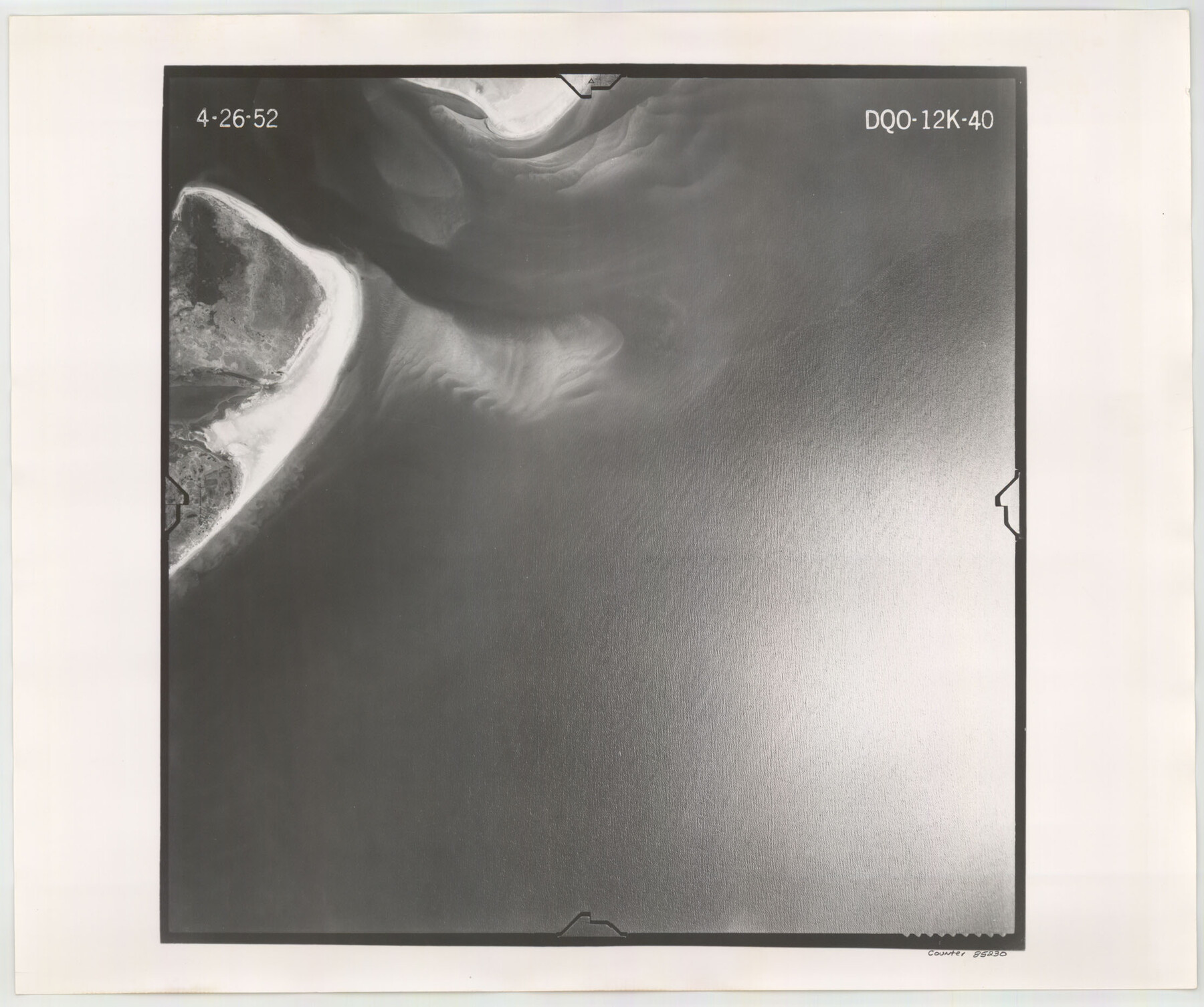
Flight Mission No. DQO-12K, Frame 40, Galveston County
DQO-12K-40
-
Map/Doc
85230
-
Collection
General Map Collection
-
Object Dates
1952/4/26 (Creation Date)
-
People and Organizations
U. S. Department of Agriculture (Publisher)
-
Counties
Galveston
-
Subjects
Aerial Photograph
-
Height x Width
18.6 x 22.3 inches
47.2 x 56.6 cm
-
Comments
Flown by Aero Exploration Company of Tulsa, Oklahoma.
Part of: General Map Collection

Township 4 South Ranges 12 and 13 West, South Western District, Louisiana

Print $20.00
- Digital $50.00
Township 4 South Ranges 12 and 13 West, South Western District, Louisiana
1879
Size 19.6 x 24.7 inches
Map/Doc 65884
[T. & G. Ry. Main Line, Texas, Right of Way Map, Center to Gary]
![64572, [T. & G. Ry. Main Line, Texas, Right of Way Map, Center to Gary], General Map Collection](https://historictexasmaps.com/wmedia_w700/maps/64572-1.tif.jpg)
Print $40.00
- Digital $50.00
[T. & G. Ry. Main Line, Texas, Right of Way Map, Center to Gary]
1917
Size 31.9 x 104.6 inches
Map/Doc 64572
Pecos County Working Sketch 91a
Print $40.00
- Digital $50.00
Pecos County Working Sketch 91a
1965
Size 78.9 x 32.5 inches
Map/Doc 71563
Cass County Working Sketch 18

Print $20.00
- Digital $50.00
Cass County Working Sketch 18
1958
Size 24.2 x 44.3 inches
Map/Doc 67921
Lynn County Sketch File 12

Print $4.00
- Digital $50.00
Lynn County Sketch File 12
1907
Size 7.5 x 8.7 inches
Map/Doc 30480
Hutchinson County Rolled Sketch 40

Print $20.00
- Digital $50.00
Hutchinson County Rolled Sketch 40
1981
Size 26.8 x 37.6 inches
Map/Doc 6301
Burnet County Sketch File 14a

Print $6.00
- Digital $50.00
Burnet County Sketch File 14a
Size 17.0 x 11.0 inches
Map/Doc 16700
Clay County Sketch File 11

Print $4.00
- Digital $50.00
Clay County Sketch File 11
1870
Size 10.1 x 7.9 inches
Map/Doc 18408
Chambers County Sketch File 21

Print $20.00
- Digital $50.00
Chambers County Sketch File 21
Size 29.3 x 32.8 inches
Map/Doc 10331
Clay County Sketch File 6

Print $4.00
- Digital $50.00
Clay County Sketch File 6
1854
Size 8.1 x 12.5 inches
Map/Doc 18395
Hansford County

Print $20.00
- Digital $50.00
Hansford County
1932
Size 39.6 x 38.5 inches
Map/Doc 77301
You may also like
Hudspeth County Sketch File 46

Print $20.00
- Digital $50.00
Hudspeth County Sketch File 46
1983
Size 17.5 x 14.0 inches
Map/Doc 27049
Hood County Working Sketch 2

Print $20.00
- Digital $50.00
Hood County Working Sketch 2
1956
Size 20.5 x 25.5 inches
Map/Doc 66196
Plat of 83.94 acre vacant tract of land showing connections to adjoining surveys

Print $20.00
- Digital $50.00
Plat of 83.94 acre vacant tract of land showing connections to adjoining surveys
1918
Size 17.7 x 21.1 inches
Map/Doc 90823
Travis County Rolled Sketch 43

Print $20.00
- Digital $50.00
Travis County Rolled Sketch 43
1962
Size 27.3 x 22.7 inches
Map/Doc 8041
Laguna Madre from Lone Palmetto Triangulation Station to Gum Pen Triangulation Station

Print $20.00
- Digital $50.00
Laguna Madre from Lone Palmetto Triangulation Station to Gum Pen Triangulation Station
1881
Size 16.2 x 27.5 inches
Map/Doc 73497
[East-Central Crosby County]
![90503, [East-Central Crosby County], Twichell Survey Records](https://historictexasmaps.com/wmedia_w700/maps/90503-1.tif.jpg)
Print $2.00
- Digital $50.00
[East-Central Crosby County]
Size 11.4 x 6.0 inches
Map/Doc 90503
[Blocks M23, XO2, Z, and 47]
![91242, [Blocks M23, XO2, Z, and 47], Twichell Survey Records](https://historictexasmaps.com/wmedia_w700/maps/91242-1.tif.jpg)
Print $20.00
- Digital $50.00
[Blocks M23, XO2, Z, and 47]
Size 19.0 x 19.5 inches
Map/Doc 91242
Flight Mission No. BRA-9M, Frame 60, Jefferson County

Print $20.00
- Digital $50.00
Flight Mission No. BRA-9M, Frame 60, Jefferson County
1953
Size 18.6 x 22.4 inches
Map/Doc 85643
Real County Rolled Sketch 7

Print $20.00
- Digital $50.00
Real County Rolled Sketch 7
Size 24.5 x 29.9 inches
Map/Doc 7457
Terrell County Working Sketch 3a

Print $20.00
- Digital $50.00
Terrell County Working Sketch 3a
1912
Size 26.1 x 21.2 inches
Map/Doc 62152
Camp County Working Sketch 1

Print $20.00
- Digital $50.00
Camp County Working Sketch 1
1970
Size 32.9 x 29.7 inches
Map/Doc 67877
Fractional Township No. 8 South Range No. 6 East of the Indian Meridian, Indian Territory

Print $20.00
- Digital $50.00
Fractional Township No. 8 South Range No. 6 East of the Indian Meridian, Indian Territory
1898
Size 19.3 x 24.4 inches
Map/Doc 75210