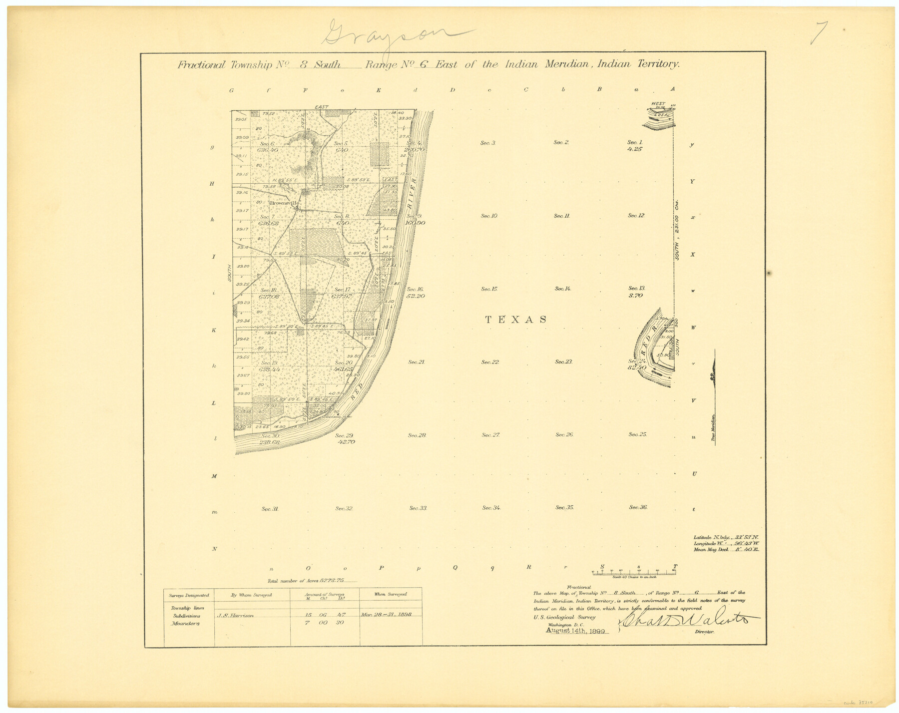
Fractional Township No. 8 South Range No. 6 East of the Indian Meridian, Indian Territory
-
Map/Doc
75210
-
Collection
General Map Collection
-
Object Dates
1898/3/31 (Creation Date)
-
Subjects
Texas Boundaries
-
Height x Width
19.3 x 24.4 inches
49.0 x 62.0 cm
Part of: General Map Collection
Crockett County Rolled Sketch RC1

Print $20.00
- Digital $50.00
Crockett County Rolled Sketch RC1
1935
Size 43.7 x 30.6 inches
Map/Doc 8701
Roberts County

Print $20.00
- Digital $50.00
Roberts County
1900
Size 43.4 x 42.0 inches
Map/Doc 63002
Real County Working Sketch 25

Print $20.00
- Digital $50.00
Real County Working Sketch 25
1946
Size 26.5 x 24.7 inches
Map/Doc 71917
Edwards County Sketch File 52

Print $20.00
- Digital $50.00
Edwards County Sketch File 52
1972
Size 19.9 x 35.1 inches
Map/Doc 11446
Lipscomb County Sketch File 6

Print $20.00
- Digital $50.00
Lipscomb County Sketch File 6
1965
Size 19.4 x 26.1 inches
Map/Doc 12005
Fort Bend County Sketch File 30

Print $18.00
- Digital $50.00
Fort Bend County Sketch File 30
1920
Size 12.1 x 6.5 inches
Map/Doc 22988
Wise County Working Sketch 9

Print $20.00
- Digital $50.00
Wise County Working Sketch 9
1957
Size 23.6 x 29.0 inches
Map/Doc 72623
Concho County Rolled Sketch 3

Print $40.00
- Digital $50.00
Concho County Rolled Sketch 3
1949
Size 67.0 x 46.0 inches
Map/Doc 8648
McCulloch County Working Sketch 11

Print $20.00
- Digital $50.00
McCulloch County Working Sketch 11
1983
Size 35.1 x 43.3 inches
Map/Doc 70686
Stephens County Rolled Sketch 6

Print $20.00
- Digital $50.00
Stephens County Rolled Sketch 6
Size 37.1 x 36.0 inches
Map/Doc 8360
Starr County Sketch File 7

Print $20.00
- Digital $50.00
Starr County Sketch File 7
Size 25.4 x 20.8 inches
Map/Doc 12326

You may also like
Pecos County Rolled Sketch 101

Print $20.00
- Digital $50.00
Pecos County Rolled Sketch 101
1938
Size 22.5 x 39.0 inches
Map/Doc 7249
Stonewall County Rolled Sketch 24A

Print $40.00
- Digital $50.00
Stonewall County Rolled Sketch 24A
1954
Size 55.0 x 47.1 inches
Map/Doc 9963
Edwards County Working Sketch 79

Print $40.00
- Digital $50.00
Edwards County Working Sketch 79
1962
Size 58.5 x 26.6 inches
Map/Doc 68955
United States - Gulf Coast - Galveston to Rio Grande

Print $20.00
- Digital $50.00
United States - Gulf Coast - Galveston to Rio Grande
1949
Size 26.6 x 18.2 inches
Map/Doc 72756
Zavala County Working Sketch 24

Print $40.00
- Digital $50.00
Zavala County Working Sketch 24
1980
Size 75.6 x 42.8 inches
Map/Doc 62099
Missouri, Kansas & Texas Ry. thro' Denison and the beautiful Indian Territory

Print $20.00
- Digital $50.00
Missouri, Kansas & Texas Ry. thro' Denison and the beautiful Indian Territory
1877
Size 15.7 x 21.7 inches
Map/Doc 95805
Coryell County Boundary File 1c

Print $6.00
- Digital $50.00
Coryell County Boundary File 1c
Size 10.2 x 8.1 inches
Map/Doc 51901
Brewster County Sketch File 50

Print $32.00
- Digital $50.00
Brewster County Sketch File 50
1995
Size 14.8 x 8.5 inches
Map/Doc 16336
Terrell County Sketch File 26

Print $38.00
- Digital $50.00
Terrell County Sketch File 26
1937
Size 10.9 x 8.2 inches
Map/Doc 37961
[Map representing Townships 21, 20 and part of 19 of Range 17 and the corresponding ones in the 16th Range, according to the United States surveys showing the Boundary between the Republic of Texas and the United States of America]
![262, [Map representing Townships 21, 20 and part of 19 of Range 17 and the corresponding ones in the 16th Range, according to the United States surveys showing the Boundary between the Republic of Texas and the United States of America], General Map Collection](https://historictexasmaps.com/wmedia_w700/maps/262.tif.jpg)
Print $20.00
- Digital $50.00
[Map representing Townships 21, 20 and part of 19 of Range 17 and the corresponding ones in the 16th Range, according to the United States surveys showing the Boundary between the Republic of Texas and the United States of America]
1841
Size 19.5 x 15.4 inches
Map/Doc 262
Stephens County Sketch File 7

Print $4.00
- Digital $50.00
Stephens County Sketch File 7
1875
Size 8.1 x 9.9 inches
Map/Doc 37025
Denton County Working Sketch 36

Print $20.00
- Digital $50.00
Denton County Working Sketch 36
2008
Size 18.5 x 29.0 inches
Map/Doc 88877