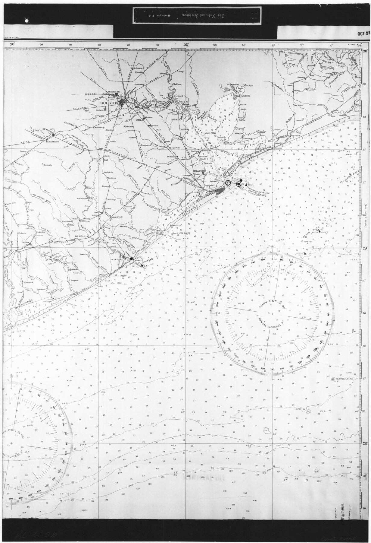
United States - Gulf Coast - Galveston to Rio Grande
RL-2-5b
-
Map/Doc
72756
-
Collection
General Map Collection
-
Object Dates
1949 (Creation Date)
-
People and Organizations
U. S. Coast and Geodetic Survey (Publisher)
-
Subjects
Nautical Charts
-
Height x Width
26.6 x 18.2 inches
67.6 x 46.2 cm
-
Comments
B/W photostat copy from National Archives in multiple pieces.
Part of: General Map Collection
Maps of Gulf Intracoastal Waterway, Texas - Sabine River to the Rio Grande and connecting waterways including ship channels

Print $20.00
- Digital $50.00
Maps of Gulf Intracoastal Waterway, Texas - Sabine River to the Rio Grande and connecting waterways including ship channels
1966
Size 14.5 x 22.2 inches
Map/Doc 61940
Cochran County Sketch File 2

Print $22.00
- Digital $50.00
Cochran County Sketch File 2
1907
Size 4.4 x 13.6 inches
Map/Doc 18539
Part of the boundary between the United States and Texas: from Sabine River northward to the 36th mile mound (A.2)

Print $2.00
- Digital $50.00
Part of the boundary between the United States and Texas: from Sabine River northward to the 36th mile mound (A.2)
1842
Size 12.5 x 7.3 inches
Map/Doc 65387

Harrison County

Print $20.00
- Digital $50.00
Harrison County
1857
Size 20.3 x 21.0 inches
Map/Doc 1116
San Patricio County Rolled Sketch 53

Print $20.00
- Digital $50.00
San Patricio County Rolled Sketch 53
1996
Size 19.1 x 25.3 inches
Map/Doc 7738
Val Verde County Sketch File 22

Print $20.00
- Digital $50.00
Val Verde County Sketch File 22
Size 14.3 x 22.3 inches
Map/Doc 12571
Milam County Working Sketch 2

Print $20.00
- Digital $50.00
Milam County Working Sketch 2
1937
Size 20.2 x 20.5 inches
Map/Doc 71017
Comal County Sketch File 3

Print $8.00
- Digital $50.00
Comal County Sketch File 3
1853
Size 4.4 x 8.4 inches
Map/Doc 18999
Crane County Working Sketch 25

Print $20.00
- Digital $50.00
Crane County Working Sketch 25
1969
Size 33.0 x 26.3 inches
Map/Doc 68302
Reagan County Rolled Sketch 20

Print $20.00
- Digital $50.00
Reagan County Rolled Sketch 20
1948
Size 45.8 x 45.0 inches
Map/Doc 9814
Childress County Sketch File 18a

Print $4.00
- Digital $50.00
Childress County Sketch File 18a
1935
Size 11.3 x 7.1 inches
Map/Doc 18364
You may also like
Galveston Harbor and Channel, Texas - Rehabilitation of Galveston Groins - Location Plan of Rehabilitation

Print $4.00
- Digital $50.00
Galveston Harbor and Channel, Texas - Rehabilitation of Galveston Groins - Location Plan of Rehabilitation
1968
Size 16.0 x 20.6 inches
Map/Doc 73620
[Worksheets related to the Wilson Strickland survey and vicinity]
![91269, [Worksheets related to the Wilson Strickland survey and vicinity], Twichell Survey Records](https://historictexasmaps.com/wmedia_w700/maps/91269.tif.jpg)
Print $20.00
- Digital $50.00
[Worksheets related to the Wilson Strickland survey and vicinity]
Size 25.7 x 21.7 inches
Map/Doc 91269
Corpus Christi Harbor

Print $40.00
- Digital $50.00
Corpus Christi Harbor
1973
Size 37.8 x 51.9 inches
Map/Doc 73478
Kenedy County

Print $20.00
- Digital $50.00
Kenedy County
1913
Size 41.0 x 31.8 inches
Map/Doc 66888
Gulf Oil Corp. Fishgide - Port Isabel

Gulf Oil Corp. Fishgide - Port Isabel
1960
Size 12.1 x 22.4 inches
Map/Doc 75981
Pecos County Rolled Sketch 81

Print $20.00
- Digital $50.00
Pecos County Rolled Sketch 81
1930
Size 35.9 x 25.4 inches
Map/Doc 7240
[Map of Starr County]
![4049, [Map of Starr County], General Map Collection](https://historictexasmaps.com/wmedia_w700/maps/4049.tif.jpg)
Print $20.00
- Digital $50.00
[Map of Starr County]
Size 18.8 x 16.2 inches
Map/Doc 4049
Flight Mission No. CRE-1R, Frame 131, Jackson County

Print $20.00
- Digital $50.00
Flight Mission No. CRE-1R, Frame 131, Jackson County
1956
Size 16.1 x 15.9 inches
Map/Doc 85339

Harrison County Rolled Sketch 5

Print $20.00
- Digital $50.00
Harrison County Rolled Sketch 5
1949
Size 33.7 x 19.3 inches
Map/Doc 6467
Hidalgo County Sketch File 12

Print $20.00
- Digital $50.00
Hidalgo County Sketch File 12
Size 16.3 x 25.1 inches
Map/Doc 11763
In the Supreme Court of the United States The State of Oklahoma, Complainant vs. The State of Texas, Defendant, The United States of America, Intervener - 1920

Print $20.00
- Digital $50.00
In the Supreme Court of the United States The State of Oklahoma, Complainant vs. The State of Texas, Defendant, The United States of America, Intervener - 1920
1920
Size 31.6 x 37.2 inches
Map/Doc 75115