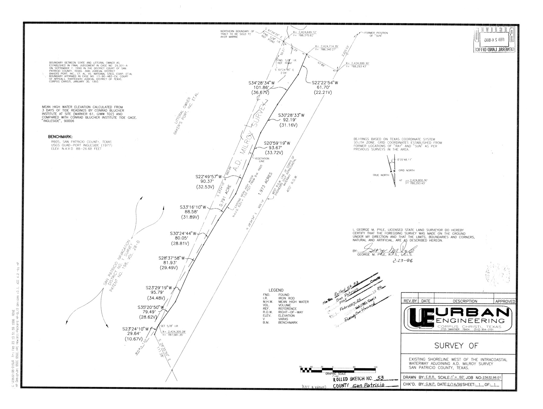
San Patricio County Rolled Sketch 53
Survey of exisiting shoreline west of the intracoastal waterway adjoining A.D. Milroy survey
-
Map/Doc
7738
-
Collection
General Map Collection
-
Object Dates
1996/2/23 (Creation Date)
1996/2/26 (File Date)
-
People and Organizations
George M. Pyle (Surveyor/Engineer)
-
Counties
San Patricio
-
Subjects
Surveying Rolled Sketch
-
Height x Width
19.1 x 25.3 inches
48.5 x 64.3 cm
-
Medium
mylar, print
Part of: General Map Collection
Brewster County Sketch File N-19

Print $40.00
- Digital $50.00
Brewster County Sketch File N-19
1946
Size 18.7 x 26.2 inches
Map/Doc 10966
Live Oak County Sketch File 13

Print $17.00
- Digital $50.00
Live Oak County Sketch File 13
1880
Size 10.2 x 13.7 inches
Map/Doc 30270
Leon County Working Sketch 25

Print $20.00
- Digital $50.00
Leon County Working Sketch 25
1968
Size 30.6 x 26.7 inches
Map/Doc 70424
[Sketch for Mineral Application 12206 - Cow Bayou, O. B. Sawyer]
![65567, [Sketch for Mineral Application 12206 - Cow Bayou, O. B. Sawyer], General Map Collection](https://historictexasmaps.com/wmedia_w700/maps/65567.tif.jpg)
Print $40.00
- Digital $50.00
[Sketch for Mineral Application 12206 - Cow Bayou, O. B. Sawyer]
Size 140.6 x 37.5 inches
Map/Doc 65567
Flight Mission No. DCL-4C, Frame 7, Kenedy County

Print $20.00
- Digital $50.00
Flight Mission No. DCL-4C, Frame 7, Kenedy County
1943
Size 18.6 x 22.3 inches
Map/Doc 85808
Donley County Rolled Sketch 6

Print $40.00
- Digital $50.00
Donley County Rolled Sketch 6
1982
Size 42.9 x 66.6 inches
Map/Doc 8802
Atascosa County Boundary File 4

Print $80.00
- Digital $50.00
Atascosa County Boundary File 4
Size 30.6 x 59.2 inches
Map/Doc 50177
Field Notes of a Survey of Padre Island

Print $20.00
- Digital $50.00
Field Notes of a Survey of Padre Island
1941
Size 43.2 x 30.0 inches
Map/Doc 2271
Crockett County Rolled Sketch 40

Print $20.00
- Digital $50.00
Crockett County Rolled Sketch 40
Size 21.9 x 14.3 inches
Map/Doc 5590

Madison County Working Sketch 1

Print $20.00
- Digital $50.00
Madison County Working Sketch 1
1913
Size 42.4 x 36.9 inches
Map/Doc 70763
Dickens County

Print $20.00
- Digital $50.00
Dickens County
1884
Size 20.9 x 19.3 inches
Map/Doc 3487
You may also like
Travis County Appraisal District Plat Map 4_1301

Print $20.00
- Digital $50.00
Travis County Appraisal District Plat Map 4_1301
Size 21.5 x 26.4 inches
Map/Doc 94213
Nueces County Sketch File 70

Print $8.00
- Digital $50.00
Nueces County Sketch File 70
Size 11.2 x 8.6 inches
Map/Doc 33007
Matagorda County Working Sketch 23

Print $20.00
- Digital $50.00
Matagorda County Working Sketch 23
1968
Size 27.4 x 35.8 inches
Map/Doc 70881
Hardin County Sketch File 35

Print $24.00
- Digital $50.00
Hardin County Sketch File 35
Size 9.2 x 8.4 inches
Map/Doc 25175
Dallas County Sketch File 16

Print $4.00
- Digital $50.00
Dallas County Sketch File 16
Size 8.0 x 8.4 inches
Map/Doc 20435
McMullen County Working Sketch 15

Print $20.00
- Digital $50.00
McMullen County Working Sketch 15
1939
Size 18.4 x 27.5 inches
Map/Doc 70716
Padre Island Under Six Flags

Print $40.00
- Digital $50.00
Padre Island Under Six Flags
1962
Size 59.3 x 30.3 inches
Map/Doc 3123
Parker County Working Sketch 21

Print $20.00
- Digital $50.00
Parker County Working Sketch 21
2006
Map/Doc 83655
Midland County Sketch File 4

Print $20.00
- Digital $50.00
Midland County Sketch File 4
1886
Size 16.3 x 18.9 inches
Map/Doc 12082
Willacy County Boundary File 2

Print $16.00
- Digital $50.00
Willacy County Boundary File 2
Size 11.0 x 8.7 inches
Map/Doc 59967
Lipscomb County Working Sketch 7

Print $20.00
- Digital $50.00
Lipscomb County Working Sketch 7
1982
Size 42.7 x 21.4 inches
Map/Doc 70583
[Galveston, Harrisburg & San Antonio Railroad from Cuero to Stockdale]
![64194, [Galveston, Harrisburg & San Antonio Railroad from Cuero to Stockdale], General Map Collection](https://historictexasmaps.com/wmedia_w700/maps/64194.tif.jpg)
Print $20.00
- Digital $50.00
[Galveston, Harrisburg & San Antonio Railroad from Cuero to Stockdale]
1907
Size 13.6 x 34.0 inches
Map/Doc 64194