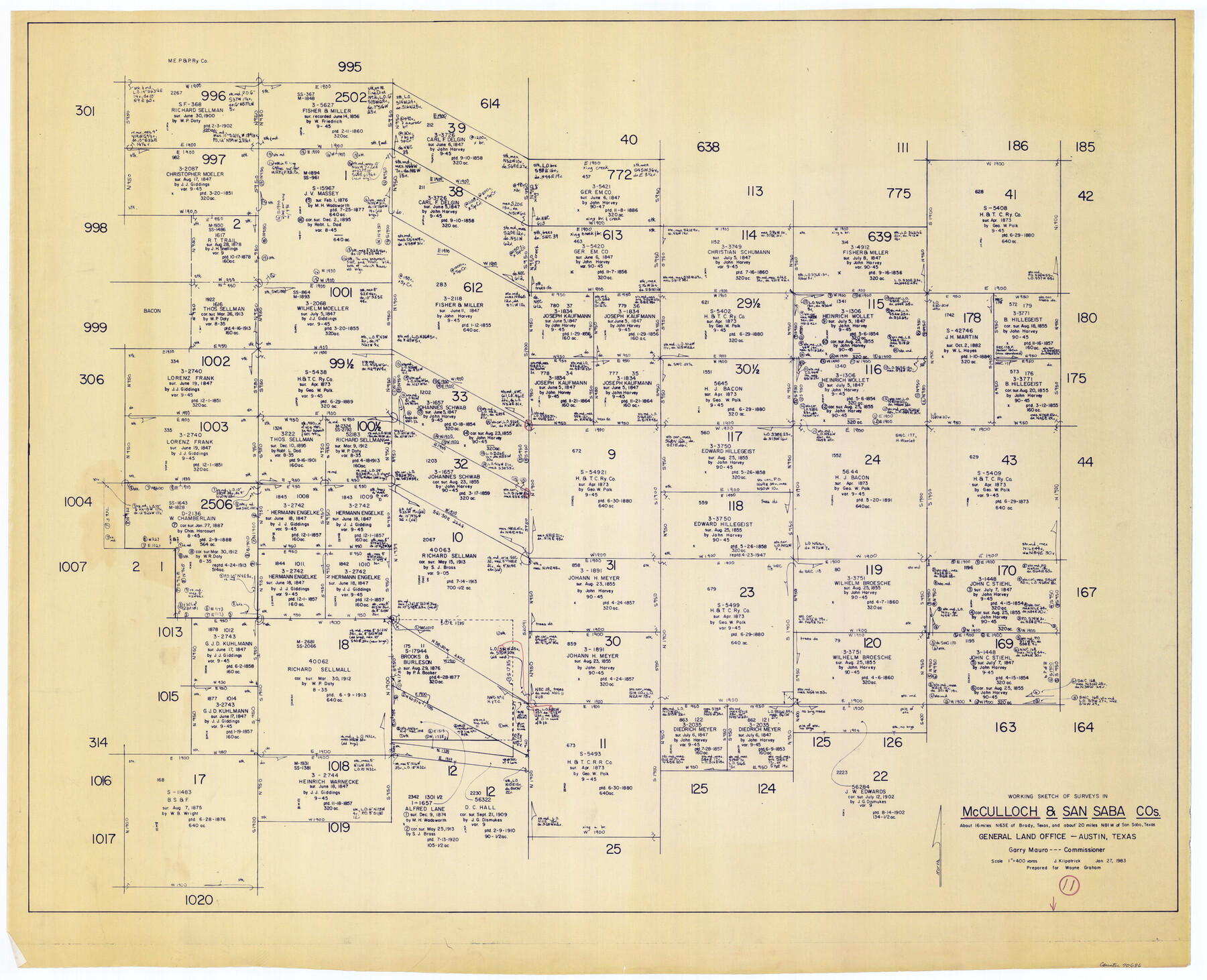
McCulloch County Working Sketch 11
-
Map/Doc
70686
-
Collection
General Map Collection
-
Object Dates
1/27/1983 (Creation Date)
-
People and Organizations
Joan Kilpatrick (Draftsman)
-
Counties
McCulloch San Saba
-
Subjects
Surveying Working Sketch
-
Height x Width
35.1 x 43.3 inches
89.2 x 110.0 cm
-
Scale
1" = 400 varas
Part of: General Map Collection
Marion County Rolled Sketch JB

Print $40.00
- Digital $50.00
Marion County Rolled Sketch JB
Size 51.9 x 23.1 inches
Map/Doc 9488
[Gulf Coast portion of] Map of the State of Texas
![72706, [Gulf Coast portion of] Map of the State of Texas, General Map Collection](https://historictexasmaps.com/wmedia_w700/maps/72706.tif.jpg)
Print $20.00
- Digital $50.00
[Gulf Coast portion of] Map of the State of Texas
1865
Size 27.2 x 18.2 inches
Map/Doc 72706
[Bastrop District]
![16941, [Bastrop District], General Map Collection](https://historictexasmaps.com/wmedia_w700/maps/16941-1.tif.jpg)
Print $40.00
- Digital $50.00
[Bastrop District]
1838
Size 67.3 x 44.2 inches
Map/Doc 16941
Irion County Working Sketch 11

Print $20.00
- Digital $50.00
Irion County Working Sketch 11
1959
Size 43.6 x 30.6 inches
Map/Doc 66420
Flight Mission No. CGI-3N, Frame 119, Cameron County

Print $20.00
- Digital $50.00
Flight Mission No. CGI-3N, Frame 119, Cameron County
1954
Size 18.5 x 22.2 inches
Map/Doc 84592
Eastland County Working Sketch 35

Print $20.00
- Digital $50.00
Eastland County Working Sketch 35
1962
Size 24.0 x 21.6 inches
Map/Doc 68816
Township 4 South Ranges 12 and 13 West, South Western District, Louisiana

Print $20.00
- Digital $50.00
Township 4 South Ranges 12 and 13 West, South Western District, Louisiana
1857
Size 18.6 x 24.2 inches
Map/Doc 65891
Flight Mission No. CGI-3N, Frame 163, Cameron County

Print $20.00
- Digital $50.00
Flight Mission No. CGI-3N, Frame 163, Cameron County
1954
Size 18.5 x 22.3 inches
Map/Doc 84627
Current Miscellaneous File 33

Print $6.00
- Digital $50.00
Current Miscellaneous File 33
1953
Size 10.8 x 8.2 inches
Map/Doc 73939
Grayson County Sketch File 18

Print $6.00
- Digital $50.00
Grayson County Sketch File 18
1859
Size 12.2 x 7.9 inches
Map/Doc 24487
Burnet County Boundary File 9

Print $12.00
- Digital $50.00
Burnet County Boundary File 9
Size 14.1 x 8.6 inches
Map/Doc 50943
El Paso County Boundary File 20

Print $9.00
- Digital $50.00
El Paso County Boundary File 20
Size 13.2 x 8.3 inches
Map/Doc 53210
You may also like
[Surveying Sketch of L. Smith, Sidney Shepherd, Kenneth Hyman, et al in Montgomery County]
![625, [Surveying Sketch of L. Smith, Sidney Shepherd, Kenneth Hyman, et al in Montgomery County], Maddox Collection](https://historictexasmaps.com/wmedia_w700/maps/00625.tif.jpg)
Print $2.00
- Digital $50.00
[Surveying Sketch of L. Smith, Sidney Shepherd, Kenneth Hyman, et al in Montgomery County]
Size 7.3 x 10.6 inches
Map/Doc 625
Edwards County Sketch File A13

Print $20.00
- Digital $50.00
Edwards County Sketch File A13
1901
Size 22.8 x 46.6 inches
Map/Doc 10444
Houston County Working Sketch 15

Print $20.00
- Digital $50.00
Houston County Working Sketch 15
1960
Size 26.3 x 20.0 inches
Map/Doc 66245
[Sketch of surveys in the vicinity of sections 171 and 172 along Pedernales]
![91882, [Sketch of surveys in the vicinity of sections 171 and 172 along Pedernales], Twichell Survey Records](https://historictexasmaps.com/wmedia_w700/maps/91882-1.tif.jpg)
Print $20.00
- Digital $50.00
[Sketch of surveys in the vicinity of sections 171 and 172 along Pedernales]
Size 17.2 x 12.9 inches
Map/Doc 91882
Potter County Working Sketch 12

Print $40.00
- Digital $50.00
Potter County Working Sketch 12
1972
Size 64.4 x 42.4 inches
Map/Doc 71672
Carta Historica y Arqueologica

Print $20.00
- Digital $50.00
Carta Historica y Arqueologica
Size 26.0 x 34.4 inches
Map/Doc 96806
City of Austin and Vicinity

Print $20.00
- Digital $50.00
City of Austin and Vicinity
1839
Size 20.4 x 19.6 inches
Map/Doc 3149
University Land, Block 48, Culberson County, Texas

Print $20.00
- Digital $50.00
University Land, Block 48, Culberson County, Texas
1938
Size 28.1 x 21.7 inches
Map/Doc 2411
Carson County

Print $20.00
- Digital $50.00
Carson County
1932
Size 42.0 x 38.5 inches
Map/Doc 73100
Hudspeth County Working Sketch 28

Print $20.00
- Digital $50.00
Hudspeth County Working Sketch 28
1972
Size 29.2 x 31.3 inches
Map/Doc 66310
Controlled Mosaic by Jack Amman Photogrammetric Engineers, Inc - Sheet 45

Print $20.00
- Digital $50.00
Controlled Mosaic by Jack Amman Photogrammetric Engineers, Inc - Sheet 45
1954
Size 20.0 x 24.0 inches
Map/Doc 83504
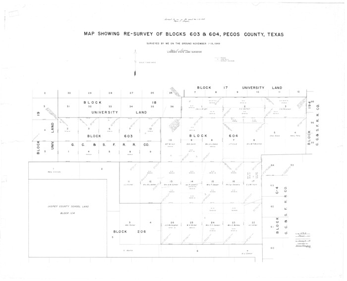
Pecos County Rolled Sketch 128A
Print $40.00
- Digital $50.00
Pecos County Rolled Sketch 128A
1949
Size 43.3 x 53.5 inches
Map/Doc 10730