Marion County Rolled Sketch 2
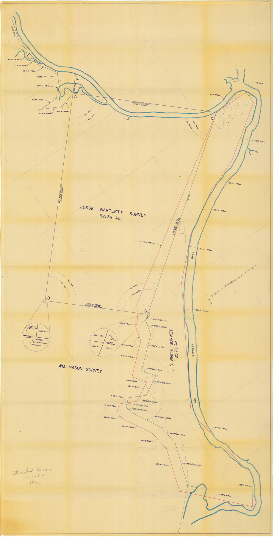
[Plat showing J.D. White and Jesse Bartlett surveys along Big Cypress Bayou regarding MA-46972]
-
Map/Doc
63912
-
Collection
General Map Collection
-
Object Dates
1954/10/1 (Creation Date)
-
Counties
Marion
-
Subjects
Surveying Rolled Sketch
-
Height x Width
89.3 x 45.7 inches
226.8 x 116.1 cm
-
Medium
van dyke/brownline/sepia
-
Scale
1" = 50 varas
-
Comments
See 46621 and 76446 for other sheets that make up this Rolled Sketch.
Related maps
Marion County Rolled Sketch 2

Print $20.00
- Digital $50.00
Marion County Rolled Sketch 2
1954
Size 34.8 x 45.9 inches
Map/Doc 46621
Marion County Rolled Sketch 2

Print $40.00
- Digital $50.00
Marion County Rolled Sketch 2
1954
Size 82.7 x 43.2 inches
Map/Doc 76446
Part of: General Map Collection

Uvalde County Working Sketch 64, revised

Print $20.00
- Digital $50.00
Uvalde County Working Sketch 64, revised
1998
Size 34.2 x 35.5 inches
Map/Doc 72135
Map of Reeves County

Print $20.00
- Digital $50.00
Map of Reeves County
1892
Size 47.2 x 35.4 inches
Map/Doc 78401
Sabine County Working Sketch 7

Print $20.00
- Digital $50.00
Sabine County Working Sketch 7
1922
Size 15.3 x 19.4 inches
Map/Doc 63678
Flight Mission No. DAH-9M, Frame 200, Orange County

Print $20.00
- Digital $50.00
Flight Mission No. DAH-9M, Frame 200, Orange County
1953
Size 18.6 x 22.4 inches
Map/Doc 86868
Marion County Rolled Sketch 10

Print $20.00
- Digital $50.00
Marion County Rolled Sketch 10
2023
Size 24.1 x 36.9 inches
Map/Doc 97192
Delta County Working Sketch 3

Print $20.00
- Digital $50.00
Delta County Working Sketch 3
1963
Size 24.9 x 24.4 inches
Map/Doc 68640
Portion of States Submerged Area in Matagorda Bay

Print $20.00
- Digital $50.00
Portion of States Submerged Area in Matagorda Bay
1922
Size 15.2 x 14.8 inches
Map/Doc 2953
Eastland County Working Sketch 14

Print $20.00
- Digital $50.00
Eastland County Working Sketch 14
1919
Size 18.2 x 17.1 inches
Map/Doc 68795
Blanco County Working Sketch 22

Print $20.00
- Digital $50.00
Blanco County Working Sketch 22
1962
Size 41.0 x 36.5 inches
Map/Doc 67382
Blanco County Working Sketch 4

Print $20.00
- Digital $50.00
Blanco County Working Sketch 4
1885
Size 20.1 x 19.4 inches
Map/Doc 67363
Lampasas County Sketch File 14

Print $6.00
- Digital $50.00
Lampasas County Sketch File 14
Size 16.2 x 10.5 inches
Map/Doc 29426
You may also like
Coke County Sketch File 17-18

Print $24.00
- Digital $50.00
Coke County Sketch File 17-18
1902
Size 16.6 x 14.2 inches
Map/Doc 11109
Harris County Rolled Sketch 88

Print $20.00
- Digital $50.00
Harris County Rolled Sketch 88
1934
Size 35.2 x 23.2 inches
Map/Doc 6120
Hale County Boundary File 7

Print $48.00
- Digital $50.00
Hale County Boundary File 7
Size 25.0 x 18.6 inches
Map/Doc 54075
Orange County Working Sketch Graphic Index - sheet B

Print $20.00
- Digital $50.00
Orange County Working Sketch Graphic Index - sheet B
1921
Size 25.2 x 30.2 inches
Map/Doc 88744
Texas Gulf Coast, from the Sabine River to the Rio Grande as Subdivided for Mineral Development; Aransas, Nueces, Kleberg, Kenedy, Willacy, and Cameron Counties

Print $40.00
- Digital $50.00
Texas Gulf Coast, from the Sabine River to the Rio Grande as Subdivided for Mineral Development; Aransas, Nueces, Kleberg, Kenedy, Willacy, and Cameron Counties
1976
Size 118.0 x 43.0 inches
Map/Doc 1940
Harris County Working Sketch 109

Print $20.00
- Digital $50.00
Harris County Working Sketch 109
1981
Size 21.4 x 27.2 inches
Map/Doc 66001
Sterling County Rolled Sketch 37

Print $20.00
- Digital $50.00
Sterling County Rolled Sketch 37
Size 13.7 x 16.6 inches
Map/Doc 7862
Laneer vs. Bivins, Potter County, Texas

Print $20.00
- Digital $50.00
Laneer vs. Bivins, Potter County, Texas
Size 21.1 x 18.8 inches
Map/Doc 93062
Live Oak County Working Sketch 2

Print $20.00
- Digital $50.00
Live Oak County Working Sketch 2
1891
Size 17.9 x 18.2 inches
Map/Doc 70587
Reagan County Rolled Sketch 8

Print $20.00
- Digital $50.00
Reagan County Rolled Sketch 8
Size 30.2 x 26.7 inches
Map/Doc 7436
Crockett County Rolled Sketch 26

Print $20.00
- Digital $50.00
Crockett County Rolled Sketch 26
Size 33.7 x 40.9 inches
Map/Doc 5585
Mills County Working Sketch 12

Print $20.00
- Digital $50.00
Mills County Working Sketch 12
1923
Size 22.1 x 26.3 inches
Map/Doc 71042