Jefferson County Rolled Sketch 12
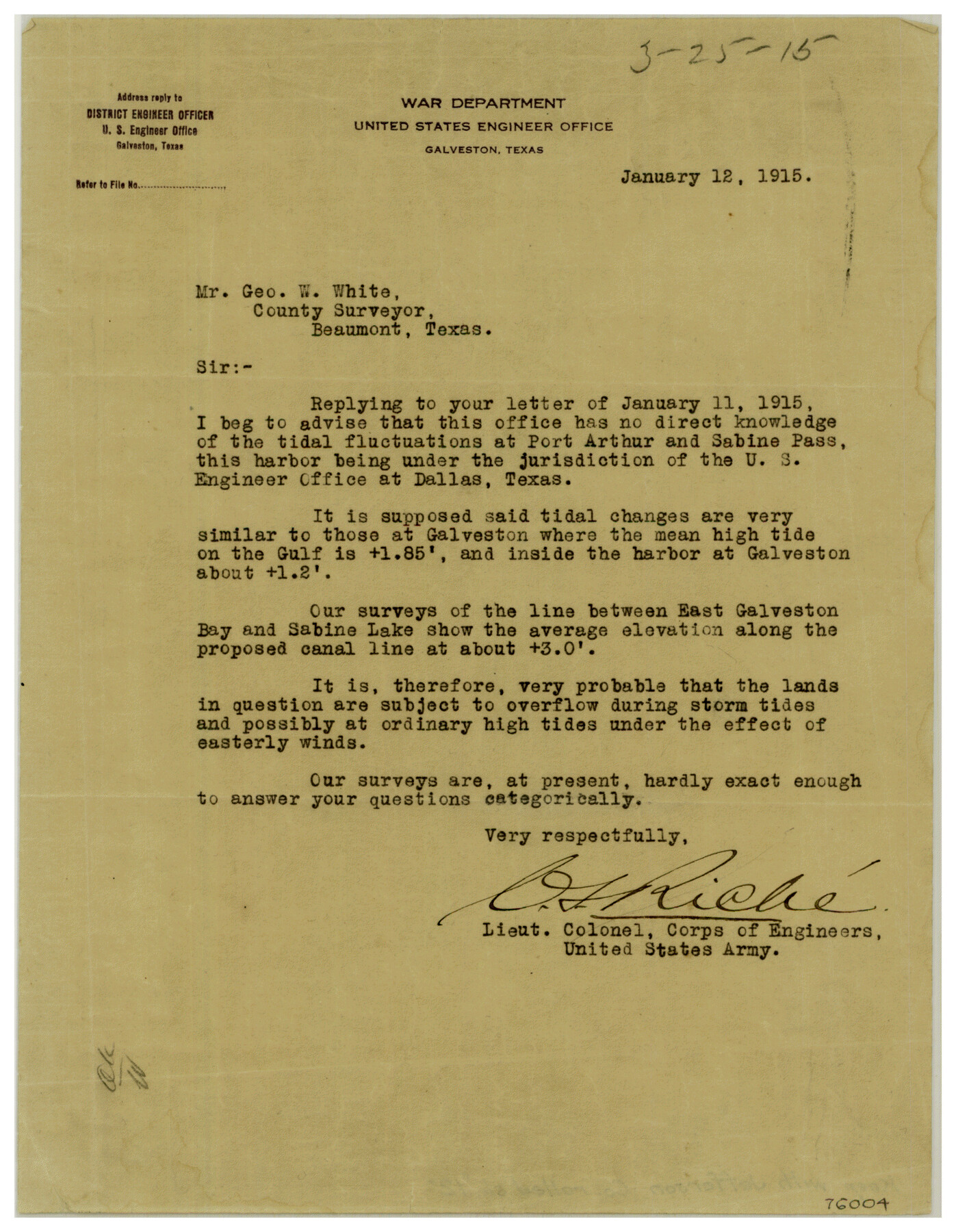
[Letter to Geo. W. White, County Surveyor from Lt. Col. Riche]
-
Map/Doc
76004
-
Collection
General Map Collection
-
Object Dates
1915/1/12 (Correspondence Date)
-
Counties
Jefferson
-
Subjects
Surveying Rolled Sketch
-
Height x Width
10.6 x 8.2 inches
26.9 x 20.8 cm
-
Medium
paper, print
-
Comments
See Jefferson County Rolled Sketch 12 (9279) for letter.
Related maps
Jefferson County Rolled Sketch 12

Print $2.00
- Digital $50.00
Jefferson County Rolled Sketch 12
Size 12.2 x 7.1 inches
Map/Doc 9279
Part of: General Map Collection
Medina County Rolled Sketch 22

Print $20.00
- Digital $50.00
Medina County Rolled Sketch 22
2007
Size 24.5 x 18.4 inches
Map/Doc 88849
Williamson County Sketch File 5

Print $13.00
- Digital $50.00
Williamson County Sketch File 5
1847
Size 8.2 x 11.2 inches
Map/Doc 40306
Gray County Sketch File 10

Print $14.00
- Digital $50.00
Gray County Sketch File 10
Size 9.7 x 6.3 inches
Map/Doc 24445

Montague County Rolled Sketch 6

Print $20.00
- Digital $50.00
Montague County Rolled Sketch 6
Size 21.8 x 30.4 inches
Map/Doc 6790
Map of Chicago, Rock Island & Texas Railway through Montague and Wise Counties, Texas

Print $20.00
- Digital $50.00
Map of Chicago, Rock Island & Texas Railway through Montague and Wise Counties, Texas
1893
Size 19.0 x 47.6 inches
Map/Doc 64469
Stonewall County

Print $20.00
- Digital $50.00
Stonewall County
1933
Size 47.6 x 39.5 inches
Map/Doc 73295
Southern Pacific Lines in Texas and Louisiana (G. H. & S. A. Ry.) Circuit Plan of Automatic Block Signals, Automatic Train Control and Flatonia Interlocking Plant No. 3

Print $40.00
- Digital $50.00
Southern Pacific Lines in Texas and Louisiana (G. H. & S. A. Ry.) Circuit Plan of Automatic Block Signals, Automatic Train Control and Flatonia Interlocking Plant No. 3
1927
Size 43.5 x 215.5 inches
Map/Doc 90044
Bexar County Working Sketch 22

Print $20.00
- Digital $50.00
Bexar County Working Sketch 22
1986
Size 16.3 x 16.1 inches
Map/Doc 67338
Randall County Rolled Sketch 8

Print $20.00
- Digital $50.00
Randall County Rolled Sketch 8
Size 16.1 x 29.8 inches
Map/Doc 7430
Upton County Sketch File 14CF

Print $8.00
- Digital $50.00
Upton County Sketch File 14CF
1926
Size 11.3 x 8.8 inches
Map/Doc 38860
Coryell County Working Sketch 3

Print $20.00
- Digital $50.00
Coryell County Working Sketch 3
1928
Size 23.6 x 22.5 inches
Map/Doc 68210
You may also like
[Northwest Part of GLO Crockett County Map]
![91569, [Northwest Part of GLO Crockett County Map], Twichell Survey Records](https://historictexasmaps.com/wmedia_w700/maps/91569-1.tif.jpg)
Print $20.00
- Digital $50.00
[Northwest Part of GLO Crockett County Map]
Size 14.0 x 19.1 inches
Map/Doc 91569
Flight Mission No. CUG-3P, Frame 45, Kleberg County

Print $20.00
- Digital $50.00
Flight Mission No. CUG-3P, Frame 45, Kleberg County
1956
Size 18.4 x 22.1 inches
Map/Doc 86250
[Corpus Christi Bay, Padre Island, Mustang Island, Laguna de la Madre, King and Kenedy's Pasture]
![73040, [Corpus Christi Bay, Padre Island, Mustang Island, Laguna de la Madre, King and Kenedy's Pasture], General Map Collection](https://historictexasmaps.com/wmedia_w700/maps/73040.tif.jpg)
Print $20.00
- Digital $50.00
[Corpus Christi Bay, Padre Island, Mustang Island, Laguna de la Madre, King and Kenedy's Pasture]
Size 18.2 x 27.0 inches
Map/Doc 73040
San Jacinto County Sketch File 13a

Print $6.00
San Jacinto County Sketch File 13a
Size 8.2 x 13.0 inches
Map/Doc 35725
Sutton County Rolled Sketch 41

Print $20.00
- Digital $50.00
Sutton County Rolled Sketch 41
1938
Size 34.5 x 23.3 inches
Map/Doc 7883

Zavala County Sketch File 46

Print $20.00
- Digital $50.00
Zavala County Sketch File 46
1937
Size 16.7 x 18.8 inches
Map/Doc 12734
North Part of Brewster Co.

Print $20.00
- Digital $50.00
North Part of Brewster Co.
1956
Size 40.0 x 37.9 inches
Map/Doc 77220
Culberson County Working Sketch 11

Print $20.00
- Digital $50.00
Culberson County Working Sketch 11
1920
Size 29.6 x 22.9 inches
Map/Doc 68463
Childress County Rolled Sketch 8B

Print $20.00
- Digital $50.00
Childress County Rolled Sketch 8B
Size 13.3 x 18.8 inches
Map/Doc 5444
Wichita County Working Sketch 15

Print $20.00
- Digital $50.00
Wichita County Working Sketch 15
1919
Size 29.9 x 38.5 inches
Map/Doc 72525
