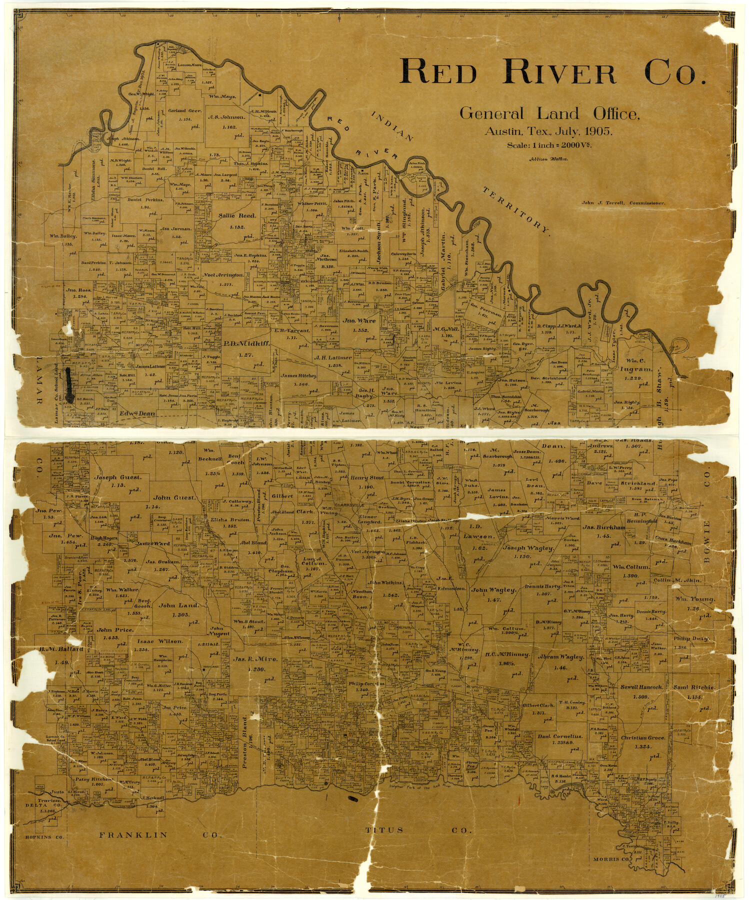
Red River Co.
-
Map/Doc
3982
-
Collection
General Map Collection
-
Object Dates
1905 (Creation Date)
-
People and Organizations
Texas General Land Office (Publisher)
John J. Terrell (GLO Commissioner)
Addison Walker (Draftsman)
Addison Walker (Compiler)
-
Counties
Red River
-
Subjects
County
-
Height x Width
45.3 x 37.7 inches
115.1 x 95.8 cm
-
Features
Halesborough
Gragg's Creek
Boggy Creek
Bland's Creek
Bruton Creek
Guest Creek
Clapham Creek
Kickapoo Creek
Avery
Cuthand Creek
Heel Tap Creek
Wayland
Jake's Creek
Big Mustang Creek
White Oak Creek
Shawnee Creek
East Fork of Caney Creek
Little Mustang Creek
Brushy Creek
Sulphur Fork of Red River
Grassy Lake
South Sulphur [Fork of Red River]
Garvinsville
Big Slough
South Fork of Pecan Bayou
Jonesborough
Red River
Albion
Atkinson Lake
Slingland Lake
Little Pine Creek
Bason's Mill Creek
Mound City
North Fork of Pecan Bayou
Pecan Bayou
White Oak Fork [of Pecan Bayou]
Kiamitia
Caney Creek
Little Creek
Detroit
Bagwell
Beaver Dam Creek
Wild Cat Creek
Turkey Creek
Ward's Creek
Clarksville
Mill Creek
Annona
Part of: General Map Collection
Map of Texas from the most recent authorities

Print $20.00
- Digital $50.00
Map of Texas from the most recent authorities
1845
Map/Doc 93945
El Paso County Sketch File 35 (4)

Print $38.00
- Digital $50.00
El Paso County Sketch File 35 (4)
1886
Size 14.3 x 9.0 inches
Map/Doc 22199
Flight Mission No. DCL-6C, Frame 19, Kenedy County

Print $20.00
- Digital $50.00
Flight Mission No. DCL-6C, Frame 19, Kenedy County
1943
Size 18.6 x 22.4 inches
Map/Doc 85876
Kimble County Working Sketch 30

Print $20.00
- Digital $50.00
Kimble County Working Sketch 30
1942
Size 24.5 x 21.6 inches
Map/Doc 70098
[Beaumont, Sour Lake and Western Ry. Right of Way and Alignment - Frisco]
![64131, [Beaumont, Sour Lake and Western Ry. Right of Way and Alignment - Frisco], General Map Collection](https://historictexasmaps.com/wmedia_w700/maps/64131.tif.jpg)
Print $20.00
- Digital $50.00
[Beaumont, Sour Lake and Western Ry. Right of Way and Alignment - Frisco]
1910
Size 20.3 x 46.2 inches
Map/Doc 64131
Flight Mission No. BRE-2P, Frame 108, Nueces County

Print $20.00
- Digital $50.00
Flight Mission No. BRE-2P, Frame 108, Nueces County
1956
Size 18.5 x 22.5 inches
Map/Doc 86793
Jack County Sketch File 14

Print $8.00
- Digital $50.00
Jack County Sketch File 14
1857
Size 10.0 x 5.7 inches
Map/Doc 27539
Duval County Rolled Sketch 48

Print $20.00
- Digital $50.00
Duval County Rolled Sketch 48
Size 21.8 x 18.5 inches
Map/Doc 5762
Presidio County Working Sketch 39

Print $20.00
- Digital $50.00
Presidio County Working Sketch 39
1948
Size 44.6 x 43.4 inches
Map/Doc 71716
Flight Mission No. CUG-3P, Frame 91, Kleberg County

Print $20.00
- Digital $50.00
Flight Mission No. CUG-3P, Frame 91, Kleberg County
1956
Size 18.4 x 22.2 inches
Map/Doc 86261
Flight Mission No. CLL-3N, Frame 45, Willacy County

Print $20.00
- Digital $50.00
Flight Mission No. CLL-3N, Frame 45, Willacy County
1954
Size 18.4 x 22.1 inches
Map/Doc 87103
Gillespie County

Print $40.00
- Digital $50.00
Gillespie County
1887
Size 38.9 x 49.8 inches
Map/Doc 4956
You may also like
Culberson County Sketch File EM

Print $7.00
- Digital $50.00
Culberson County Sketch File EM
Size 36.2 x 40.3 inches
Map/Doc 10359
Crane County Rolled Sketch 15

Print $40.00
- Digital $50.00
Crane County Rolled Sketch 15
1946
Size 27.2 x 49.5 inches
Map/Doc 8682
Tom Green County Working Sketch Graphic Index

Print $40.00
- Digital $50.00
Tom Green County Working Sketch Graphic Index
1942
Size 70.9 x 40.1 inches
Map/Doc 76715
Briscoe County Working Sketch 1

Print $20.00
- Digital $50.00
Briscoe County Working Sketch 1
Size 39.6 x 18.5 inches
Map/Doc 67804
Brazoria County, Texas

Print $20.00
- Digital $50.00
Brazoria County, Texas
1877
Size 24.7 x 21.7 inches
Map/Doc 425
Pecos County Working Sketch 99

Print $20.00
- Digital $50.00
Pecos County Working Sketch 99
1970
Size 43.4 x 31.2 inches
Map/Doc 71572
Travis County Rolled Sketch 3

Print $40.00
- Digital $50.00
Travis County Rolled Sketch 3
1902
Size 37.2 x 48.0 inches
Map/Doc 10009
Map of Texas from the most recent authorities

Print $20.00
- Digital $50.00
Map of Texas from the most recent authorities
1845
Size 14.2 x 18.0 inches
Map/Doc 96628
Reeves County

Print $20.00
- Digital $50.00
Reeves County
1915
Size 23.6 x 29.8 inches
Map/Doc 92896
[Surveys in the Victoria District along the Guadalupe and Coleto Rivers]
![21, [Surveys in the Victoria District along the Guadalupe and Coleto Rivers], General Map Collection](https://historictexasmaps.com/wmedia_w700/maps/21.tif.jpg)
Print $20.00
- Digital $50.00
[Surveys in the Victoria District along the Guadalupe and Coleto Rivers]
1840
Size 26.0 x 19.6 inches
Map/Doc 21
Upton County Working Sketch 17

Print $20.00
- Digital $50.00
Upton County Working Sketch 17
1941
Size 36.1 x 22.1 inches
Map/Doc 69513
Johnson County Working Sketch 31

Print $20.00
- Digital $50.00
Johnson County Working Sketch 31
2007
Size 21.2 x 22.0 inches
Map/Doc 87499