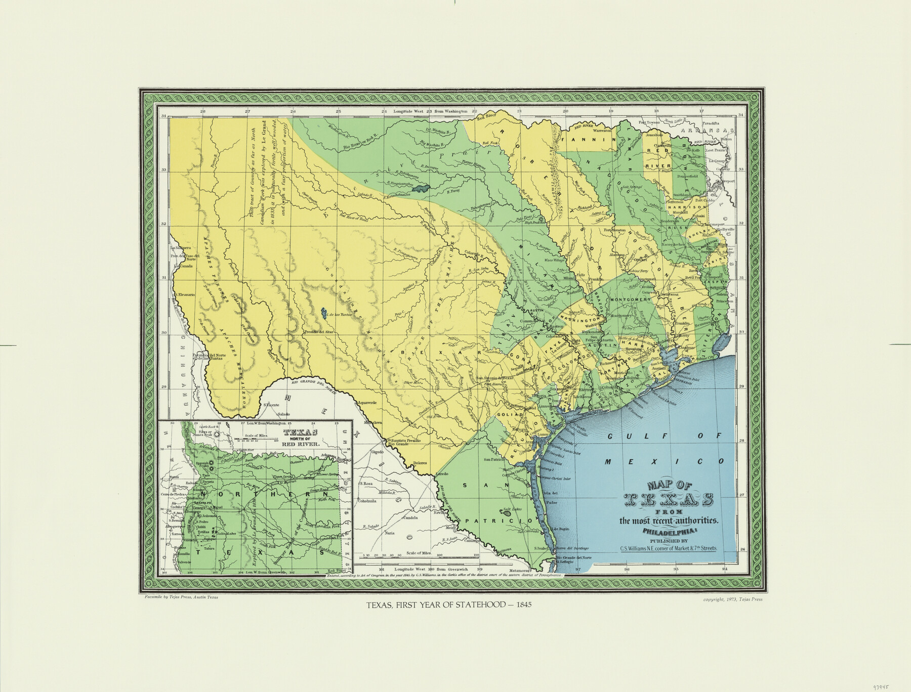
Map of Texas from the most recent authorities
Texas, First Year of Statehood - 1845
-
Map/Doc
93945
-
Collection
General Map Collection
-
Object Dates
1845 (Creation Date)
2015/9/16 (File Date)
1973 (Copy/Tracing Date)
-
People and Organizations
C. S. Williams (Publisher)
-
Subjects
State of Texas
-
Comments
Facsimile published by Tejas Press in 1973 featuring added color.
Part of: General Map Collection
Jack County Boundary File 1a

Print $16.00
- Digital $50.00
Jack County Boundary File 1a
Size 10.7 x 8.4 inches
Map/Doc 55376
Trinity County Working Sketch Graphic Index

Print $20.00
- Digital $50.00
Trinity County Working Sketch Graphic Index
1946
Size 41.3 x 41.6 inches
Map/Doc 76718
Washington County Sketch File 5

Print $4.00
- Digital $50.00
Washington County Sketch File 5
Size 8.0 x 7.0 inches
Map/Doc 39652
Mills County Sketch File 27

Print $8.00
- Digital $50.00
Mills County Sketch File 27
2000
Size 14.4 x 8.7 inches
Map/Doc 31680
Real County Rolled Sketch 18

Print $20.00
- Digital $50.00
Real County Rolled Sketch 18
Size 22.0 x 28.0 inches
Map/Doc 7464
San Augustine County Working Sketch 14

Print $20.00
- Digital $50.00
San Augustine County Working Sketch 14
1958
Size 22.7 x 26.1 inches
Map/Doc 63702
[Surveys in Power and Hewetson's Colony along the San Antonio and Guadalupe Rivers]
![23, [Surveys in Power and Hewetson's Colony along the San Antonio and Guadalupe Rivers], General Map Collection](https://historictexasmaps.com/wmedia_w700/maps/23.tif.jpg)
Print $20.00
- Digital $50.00
[Surveys in Power and Hewetson's Colony along the San Antonio and Guadalupe Rivers]
1837
Size 14.9 x 16.5 inches
Map/Doc 23
Mason County Working Sketch 11

Print $20.00
- Digital $50.00
Mason County Working Sketch 11
1951
Size 24.7 x 23.7 inches
Map/Doc 70847
Bastrop County Working Sketch 7

Print $20.00
- Digital $50.00
Bastrop County Working Sketch 7
1930
Size 32.7 x 29.7 inches
Map/Doc 67307
Fayette County

Print $40.00
- Digital $50.00
Fayette County
1978
Size 42.8 x 54.5 inches
Map/Doc 77278
Terry County Rolled Sketch 8

Print $20.00
- Digital $50.00
Terry County Rolled Sketch 8
Size 31.7 x 22.3 inches
Map/Doc 7982
Nueces River, Corpus Christi Sheet No. 1-A

Print $6.00
- Digital $50.00
Nueces River, Corpus Christi Sheet No. 1-A
1938
Size 21.9 x 33.2 inches
Map/Doc 65090
You may also like
Jack County Working Sketch Graphic Index

Print $20.00
- Digital $50.00
Jack County Working Sketch Graphic Index
1925
Size 45.4 x 37.3 inches
Map/Doc 76589
Tom Green County Rolled Sketch 14

Print $20.00
- Digital $50.00
Tom Green County Rolled Sketch 14
1953
Size 26.7 x 28.4 inches
Map/Doc 8000
Kendall County Working Sketch 13

Print $20.00
- Digital $50.00
Kendall County Working Sketch 13
1959
Size 25.5 x 30.5 inches
Map/Doc 66685
Map of Palo Pinto County, east of the Brazos River, Robertson - west of it, Milam Land District

Print $20.00
- Digital $50.00
Map of Palo Pinto County, east of the Brazos River, Robertson - west of it, Milam Land District
1859
Size 27.4 x 22.3 inches
Map/Doc 3935
Flight Mission No. CUG-3P, Frame 190, Kleberg County

Print $20.00
- Digital $50.00
Flight Mission No. CUG-3P, Frame 190, Kleberg County
1956
Size 18.6 x 22.4 inches
Map/Doc 86294
Dawson County Sketch File 12

Print $20.00
- Digital $50.00
Dawson County Sketch File 12
Size 21.9 x 20.7 inches
Map/Doc 11294

Wichita County Sketch File 3

Print $8.00
- Digital $50.00
Wichita County Sketch File 3
1856
Size 7.2 x 16.3 inches
Map/Doc 40033
Potter County Sketch File 13

Print $20.00
- Digital $50.00
Potter County Sketch File 13
Size 21.6 x 16.6 inches
Map/Doc 12199
Cooke County Working Sketch 11

Print $20.00
- Digital $50.00
Cooke County Working Sketch 11
1940
Size 42.6 x 28.2 inches
Map/Doc 68248
Map of Trinity County

Print $20.00
- Digital $50.00
Map of Trinity County
1862
Size 21.0 x 31.3 inches
Map/Doc 4096
Flight Mission No. DCL-6C, Frame 49, Kenedy County

Print $20.00
- Digital $50.00
Flight Mission No. DCL-6C, Frame 49, Kenedy County
1943
Size 18.6 x 22.5 inches
Map/Doc 85891