El Paso County Sketch File 35 (4)
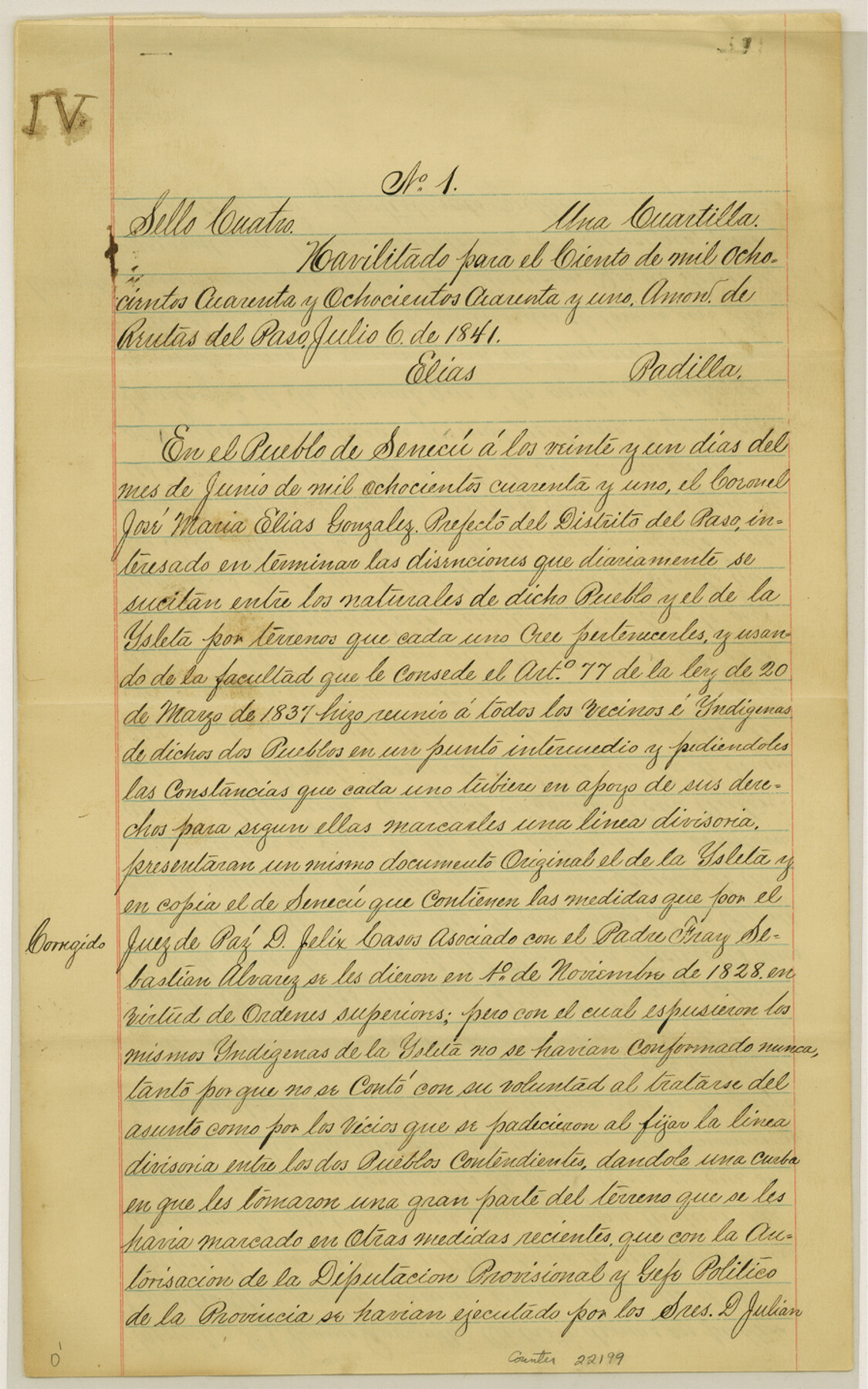
[Establishment of the division line between Pueblo de Seneca and the Town of Ysleta]
-
Map/Doc
22199
-
Collection
General Map Collection
-
Object Dates
3/18/1886 (Creation Date)
12/12/1984 (File Date)
-
Counties
El Paso
-
Subjects
Surveying Sketch File
-
Height x Width
14.3 x 9.0 inches
36.3 x 22.9 cm
-
Medium
paper, manuscript
-
Comments
See related: El Paso County Sketch Files 35 (22161), 35(1) (22166), 35(2) (22170), 35(3) (22179), 35(5) (22218), 35(6) (11460)
Formerly filed as Letter File 194001 ½ -
Features
Ysleta
Senecu
Mesa del Figua
Colorado Hill
Loma del Tigue
Loma del Negro
Socorro
El Paso
Related maps
El Paso County Sketch File 35 (6)

Print $20.00
- Digital $50.00
El Paso County Sketch File 35 (6)
1886
Size 20.3 x 36.9 inches
Map/Doc 11460
El Paso County Sketch File 35

Print $10.00
- Digital $50.00
El Paso County Sketch File 35
1886
Size 11.3 x 8.9 inches
Map/Doc 22161
El Paso County Sketch File 35 (1)

Print $8.00
- Digital $50.00
El Paso County Sketch File 35 (1)
Size 13.0 x 8.3 inches
Map/Doc 22166
El Paso County Sketch File 35 (2)

Print $18.00
- Digital $50.00
El Paso County Sketch File 35 (2)
1886
Size 12.9 x 8.3 inches
Map/Doc 22170
El Paso County Sketch File 35 (3)

Print $40.00
- Digital $50.00
El Paso County Sketch File 35 (3)
1886
Size 12.8 x 8.3 inches
Map/Doc 22179
El Paso County Sketch File 35 (5)

Print $6.00
- Digital $50.00
El Paso County Sketch File 35 (5)
1886
Size 14.6 x 8.9 inches
Map/Doc 22218
Part of: General Map Collection
San Augustine County Sketch File 21

Print $4.00
- Digital $50.00
San Augustine County Sketch File 21
1873
Size 12.8 x 7.9 inches
Map/Doc 35685
Jefferson County Rolled Sketch 61D

Print $20.00
- Digital $50.00
Jefferson County Rolled Sketch 61D
Size 27.2 x 40.5 inches
Map/Doc 6413
El Paso County Rolled Sketch 2A

Print $20.00
- Digital $50.00
El Paso County Rolled Sketch 2A
1889
Size 24.1 x 32.8 inches
Map/Doc 5821
Crockett County Sketch File 56

Print $20.00
- Digital $50.00
Crockett County Sketch File 56
Size 19.6 x 19.0 inches
Map/Doc 11224
Texas Intracoastal Waterway - Port O'Connor to San Antonio Bay, Including Pass Cavallo

Print $20.00
- Digital $50.00
Texas Intracoastal Waterway - Port O'Connor to San Antonio Bay, Including Pass Cavallo
1961
Size 26.5 x 38.7 inches
Map/Doc 73373
Harris County Rolled Sketch 71

Print $20.00
- Digital $50.00
Harris County Rolled Sketch 71
1944
Size 19.3 x 26.7 inches
Map/Doc 6111
Val Verde County Working Sketch 119

Print $40.00
- Digital $50.00
Val Verde County Working Sketch 119
2005
Size 30.5 x 50.0 inches
Map/Doc 83588
Bee County Sketch File 18

Print $6.00
- Digital $50.00
Bee County Sketch File 18
1880
Size 11.8 x 10.3 inches
Map/Doc 14303
Morris County Working Sketch 3

Print $20.00
- Digital $50.00
Morris County Working Sketch 3
1958
Size 27.6 x 38.2 inches
Map/Doc 71202
Nueces County Sketch File 3

Print $40.00
- Digital $50.00
Nueces County Sketch File 3
1847
Size 12.5 x 15.1 inches
Map/Doc 32503
Map of Galveston West Bay and Part of Galveston Island

Print $40.00
- Digital $50.00
Map of Galveston West Bay and Part of Galveston Island
1851
Size 31.2 x 52.6 inches
Map/Doc 69923
[F. W. & D. C. Ry. Co. Alignment and Right of Way Map, Clay County]
![64736, [F. W. & D. C. Ry. Co. Alignment and Right of Way Map, Clay County], General Map Collection](https://historictexasmaps.com/wmedia_w700/maps/64736-GC.tif.jpg)
Print $20.00
- Digital $50.00
[F. W. & D. C. Ry. Co. Alignment and Right of Way Map, Clay County]
1927
Size 18.6 x 11.7 inches
Map/Doc 64736
You may also like
Andrews County Working Sketch 34

Print $20.00
- Digital $50.00
Andrews County Working Sketch 34
1990
Size 29.9 x 31.0 inches
Map/Doc 67080
McMullen County Working Sketch 7

Print $20.00
- Digital $50.00
McMullen County Working Sketch 7
1926
Size 20.7 x 17.5 inches
Map/Doc 70708
Liberty County Working Sketch 10

Print $40.00
- Digital $50.00
Liberty County Working Sketch 10
1909
Size 38.9 x 48.3 inches
Map/Doc 70469
San Patricio County Rolled Sketch 46

Print $20.00
- Digital $50.00
San Patricio County Rolled Sketch 46
1983
Size 19.6 x 25.5 inches
Map/Doc 7730
Hudspeth County Rolled Sketch 45

Print $20.00
- Digital $50.00
Hudspeth County Rolled Sketch 45
1958
Size 20.5 x 35.6 inches
Map/Doc 6254
General Highway Map, Polk County, Texas

Print $20.00
General Highway Map, Polk County, Texas
1961
Size 18.1 x 24.5 inches
Map/Doc 79630
Glasscock County

Print $20.00
- Digital $50.00
Glasscock County
1933
Size 45.1 x 37.6 inches
Map/Doc 73158
Harris County Rolled Sketch 41(1)

Print $13.00
- Digital $50.00
Harris County Rolled Sketch 41(1)
Size 10.0 x 15.3 inches
Map/Doc 45789
Reeves County Working Sketch 33
Print $20.00
- Digital $50.00
Reeves County Working Sketch 33
1970
Size 39.9 x 45.7 inches
Map/Doc 63476
Guadalupe County Sketch File 7

Print $20.00
- Digital $50.00
Guadalupe County Sketch File 7
Size 15.6 x 19.5 inches
Map/Doc 11590
[Surveys in Austin's Colony along Buffalo Bayou and the San Jacinto River]
![207, [Surveys in Austin's Colony along Buffalo Bayou and the San Jacinto River], General Map Collection](https://historictexasmaps.com/wmedia_w700/maps/207.tif.jpg)
Print $20.00
- Digital $50.00
[Surveys in Austin's Colony along Buffalo Bayou and the San Jacinto River]
1824
Size 22.3 x 14.3 inches
Map/Doc 207
Jefferson County NRC Article 33.136 Location Key Sheet

Print $20.00
- Digital $50.00
Jefferson County NRC Article 33.136 Location Key Sheet
1970
Size 27.0 x 23.0 inches
Map/Doc 82995