El Paso County Sketch File 35 (1)
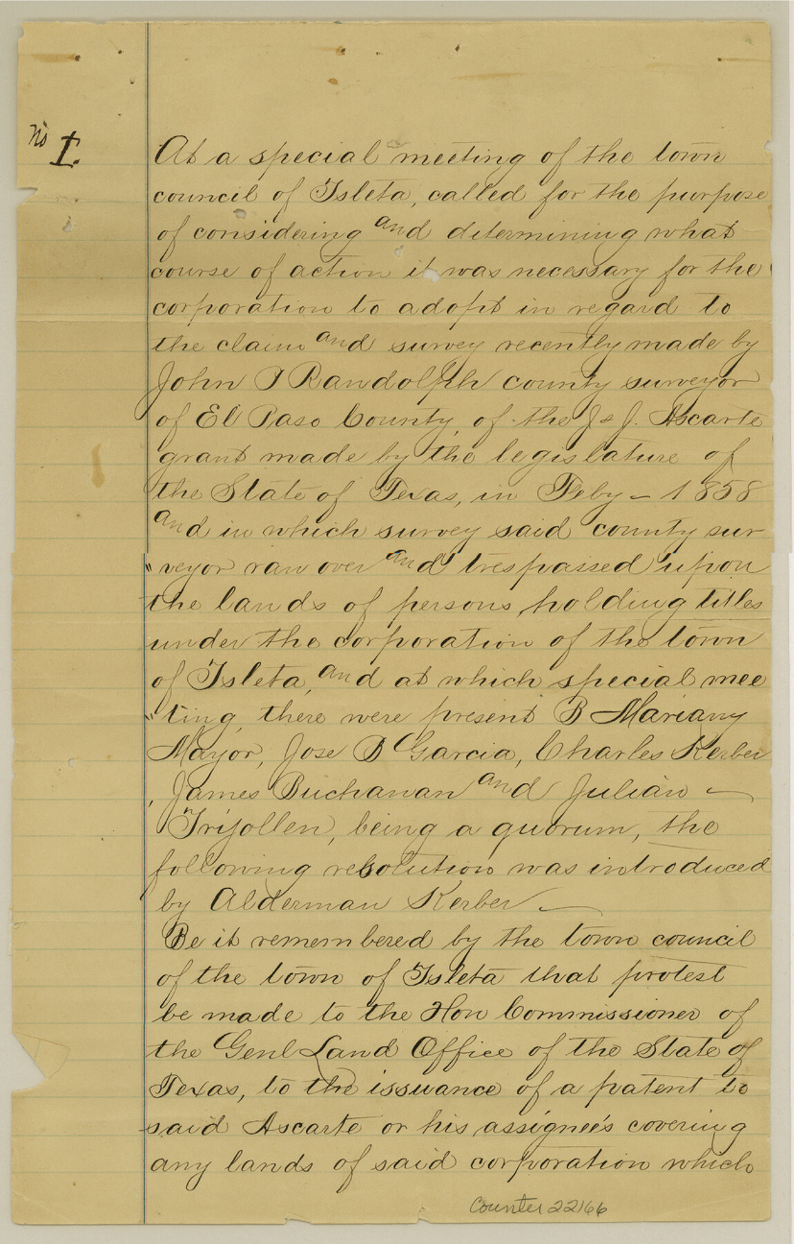
[Resolution of the Town Council of Ysleta]
-
Map/Doc
22166
-
Collection
General Map Collection
-
Object Dates
12/12/1984 (File Date)
2/1858 (Survey Date)
1873 (Survey Date)
1853 (Survey Date)
-
People and Organizations
John P. Randolph (Surveyor/Engineer)
J.W. Tays (Surveyor/Engineer)
-
Counties
El Paso
-
Subjects
Surveying Sketch File
-
Height x Width
13.0 x 8.3 inches
33.0 x 21.1 cm
-
Medium
paper, manuscript
-
Comments
See related: El Paso County Sketch Files 35 (22161), 35(2) (22170), 35(3) (22179), 35(4) (22199), 35(5) (22218), 35(6) (11460)
Formerly filed as Letter File 194001 ½ -
Features
Isleta [sic]
Related maps
El Paso County Sketch File 35 (6)

Print $20.00
- Digital $50.00
El Paso County Sketch File 35 (6)
1886
Size 20.3 x 36.9 inches
Map/Doc 11460
El Paso County Sketch File 35

Print $10.00
- Digital $50.00
El Paso County Sketch File 35
1886
Size 11.3 x 8.9 inches
Map/Doc 22161
El Paso County Sketch File 35 (2)

Print $18.00
- Digital $50.00
El Paso County Sketch File 35 (2)
1886
Size 12.9 x 8.3 inches
Map/Doc 22170
El Paso County Sketch File 35 (3)

Print $40.00
- Digital $50.00
El Paso County Sketch File 35 (3)
1886
Size 12.8 x 8.3 inches
Map/Doc 22179
El Paso County Sketch File 35 (4)

Print $38.00
- Digital $50.00
El Paso County Sketch File 35 (4)
1886
Size 14.3 x 9.0 inches
Map/Doc 22199
El Paso County Sketch File 35 (5)

Print $6.00
- Digital $50.00
El Paso County Sketch File 35 (5)
1886
Size 14.6 x 8.9 inches
Map/Doc 22218
Part of: General Map Collection
A How to Get From Here to There Map and Water Too of Metropolitan Houston

A How to Get From Here to There Map and Water Too of Metropolitan Houston
Size 36.6 x 25.5 inches
Map/Doc 94361
Martin County Rolled Sketch 4

Print $20.00
- Digital $50.00
Martin County Rolled Sketch 4
1908
Size 40.9 x 24.8 inches
Map/Doc 6665
Moore County Working Sketch 8

Print $20.00
- Digital $50.00
Moore County Working Sketch 8
1948
Size 23.2 x 31.8 inches
Map/Doc 71190
Shelby County Sketch File 34

Print $3.00
- Digital $50.00
Shelby County Sketch File 34
1847
Size 10.1 x 15.7 inches
Map/Doc 36674
Tarrant County Sketch File 29a

Print $4.00
- Digital $50.00
Tarrant County Sketch File 29a
1876
Size 8.2 x 12.8 inches
Map/Doc 37747
Map of the Trinity Artesian Reservoirs of the Black and Grand Prairies of Texas including the Eastern and Western Cross Timbers

Print $20.00
- Digital $50.00
Map of the Trinity Artesian Reservoirs of the Black and Grand Prairies of Texas including the Eastern and Western Cross Timbers
1900
Size 32.7 x 31.9 inches
Map/Doc 75920
Haskell County Rolled Sketch 8

Print $20.00
- Digital $50.00
Haskell County Rolled Sketch 8
1954
Size 43.4 x 47.7 inches
Map/Doc 9146
Outer Continental Shelf Leasing Maps (Louisiana Offshore Operations)

Print $20.00
- Digital $50.00
Outer Continental Shelf Leasing Maps (Louisiana Offshore Operations)
1954
Size 11.3 x 12.4 inches
Map/Doc 76117
Motley County Sketch File 6B (S)

Print $20.00
- Digital $50.00
Motley County Sketch File 6B (S)
Size 24.5 x 20.7 inches
Map/Doc 42139
Survey of 77 Blocks, State University Land

Survey of 77 Blocks, State University Land
1884
Size 13.5 x 8.5 inches
Map/Doc 81693
Harris County Rolled Sketch R & B

Print $40.00
- Digital $50.00
Harris County Rolled Sketch R & B
1901
Size 27.9 x 60.6 inches
Map/Doc 8344
Flight Mission No. CRK-3P, Frame 178, Refugio County

Print $20.00
- Digital $50.00
Flight Mission No. CRK-3P, Frame 178, Refugio County
1956
Size 18.4 x 22.2 inches
Map/Doc 86925
You may also like
Hardeman County Rolled Sketch 24

Print $20.00
- Digital $50.00
Hardeman County Rolled Sketch 24
1959
Size 26.8 x 32.2 inches
Map/Doc 6074
Stieler Map of 1879

Print $4.00
- Digital $50.00
Stieler Map of 1879
1879
Size 28.9 x 23.0 inches
Map/Doc 76057
[Resurvey of Block Number 01- W. H. Godair Surveys]
![92585, [Resurvey of Block Number 01- W. H. Godair Surveys], Twichell Survey Records](https://historictexasmaps.com/wmedia_w700/maps/92585-1.tif.jpg)
Print $20.00
- Digital $50.00
[Resurvey of Block Number 01- W. H. Godair Surveys]
1923
Size 33.9 x 14.9 inches
Map/Doc 92585
Harrison County Working Sketch 10

Print $20.00
- Digital $50.00
Harrison County Working Sketch 10
1957
Size 25.8 x 24.6 inches
Map/Doc 66030
[Sketch N, showing Blocks 5-7, 13, 48-51, and C1-7]
![91771, [Sketch N, showing Blocks 5-7, 13, 48-51, and C1-7], Twichell Survey Records](https://historictexasmaps.com/wmedia_w700/maps/91771-1.tif.jpg)
Print $20.00
- Digital $50.00
[Sketch N, showing Blocks 5-7, 13, 48-51, and C1-7]
Size 32.1 x 25.9 inches
Map/Doc 91771

[Sketch of area just south of Levi Pruitt survey]
![91854, [Sketch of area just south of Levi Pruitt survey], Twichell Survey Records](https://historictexasmaps.com/wmedia_w700/maps/91854-1.tif.jpg)
Print $20.00
- Digital $50.00
[Sketch of area just south of Levi Pruitt survey]
Size 24.9 x 18.6 inches
Map/Doc 91854
Fannin County Sketch File 11

Print $6.00
- Digital $50.00
Fannin County Sketch File 11
1860
Size 9.9 x 7.4 inches
Map/Doc 22457
Nueces County Sketch File 2

Print $24.00
- Digital $50.00
Nueces County Sketch File 2
1847
Size 7.6 x 12.5 inches
Map/Doc 32500
Brewster County Working Sketch 85

Print $20.00
- Digital $50.00
Brewster County Working Sketch 85
1973
Size 43.2 x 34.0 inches
Map/Doc 67685
Tom Green County Rolled Sketch 20

Print $20.00
- Digital $50.00
Tom Green County Rolled Sketch 20
Size 20.7 x 13.3 inches
Map/Doc 8003
Flight Mission No. DQN-2K, Frame 114, Calhoun County

Print $20.00
- Digital $50.00
Flight Mission No. DQN-2K, Frame 114, Calhoun County
1953
Size 18.5 x 22.2 inches
Map/Doc 84290