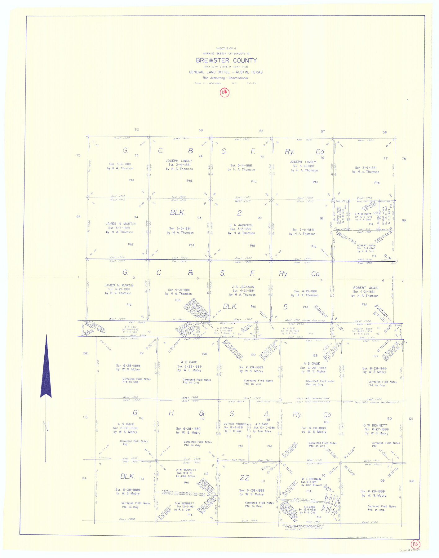
Brewster County Working Sketch 85
-
Map/Doc
67685
-
Collection
General Map Collection
-
Object Dates
5/7/1973 (Creation Date)
-
Counties
Brewster
-
Subjects
Surveying Working Sketch
-
Height x Width
43.2 x 34.0 inches
109.7 x 86.4 cm
-
Scale
1" = 400 varas
Part of: General Map Collection
Morris County Rolled Sketch 2A

Print $20.00
- Digital $50.00
Morris County Rolled Sketch 2A
Size 24.0 x 18.8 inches
Map/Doc 10238
Flight Mission No. DQN-2K, Frame 158, Calhoun County

Print $20.00
- Digital $50.00
Flight Mission No. DQN-2K, Frame 158, Calhoun County
1953
Size 18.4 x 22.3 inches
Map/Doc 84320
Donley County Sketch File B3

Print $20.00
- Digital $50.00
Donley County Sketch File B3
1918
Size 22.0 x 15.0 inches
Map/Doc 11373
Palo Pinto County Working Sketch 6

Print $20.00
- Digital $50.00
Palo Pinto County Working Sketch 6
1921
Map/Doc 71389
[New York, Texas & Mexican Railway]
![64148, [New York, Texas & Mexican Railway], General Map Collection](https://historictexasmaps.com/wmedia_w700/maps/64148.tif.jpg)
Print $20.00
- Digital $50.00
[New York, Texas & Mexican Railway]
Size 12.1 x 24.1 inches
Map/Doc 64148
Archer County Sketch File 11

Print $4.00
- Digital $50.00
Archer County Sketch File 11
Size 10.4 x 8.5 inches
Map/Doc 13644
Flight Mission No. CUG-2P, Frame 85, Kleberg County

Print $20.00
- Digital $50.00
Flight Mission No. CUG-2P, Frame 85, Kleberg County
1956
Size 18.5 x 22.2 inches
Map/Doc 86217
Hockley County Rolled Sketch 7

Print $40.00
- Digital $50.00
Hockley County Rolled Sketch 7
Size 41.4 x 56.6 inches
Map/Doc 9176
Brewster County Sketch File N-24

Print $40.00
- Digital $50.00
Brewster County Sketch File N-24
Size 23.9 x 16.4 inches
Map/Doc 10970
Reagan County Sketch File 15

Print $4.00
- Digital $50.00
Reagan County Sketch File 15
1931
Size 8.0 x 13.3 inches
Map/Doc 35000
Nueces County Working Sketch 11

Print $20.00
- Digital $50.00
Nueces County Working Sketch 11
1965
Size 20.2 x 44.1 inches
Map/Doc 71313
Calhoun County NRC Article 33.136 Location Key Sheet

Print $20.00
- Digital $50.00
Calhoun County NRC Article 33.136 Location Key Sheet
1973
Size 27.0 x 22.0 inches
Map/Doc 77010
You may also like
[Sketch highlighting Bob Reid and Fred Turner surveys]
![91693, [Sketch highlighting Bob Reid and Fred Turner surveys], Twichell Survey Records](https://historictexasmaps.com/wmedia_w700/maps/91693-1.tif.jpg)
Print $20.00
- Digital $50.00
[Sketch highlighting Bob Reid and Fred Turner surveys]
Size 12.5 x 17.8 inches
Map/Doc 91693
Winkler County Rolled Sketch 5

Print $40.00
- Digital $50.00
Winkler County Rolled Sketch 5
1927
Size 58.0 x 38.4 inches
Map/Doc 10148
Hardin County Rolled Sketch 3

Print $20.00
- Digital $50.00
Hardin County Rolled Sketch 3
1902
Size 20.1 x 17.0 inches
Map/Doc 6076
Val Verde County Working Sketch 61

Print $20.00
- Digital $50.00
Val Verde County Working Sketch 61
1958
Size 25.1 x 32.9 inches
Map/Doc 72196
[Sketch for Mineral Application 20124, North Fork of Red River]
![77087, [Sketch for Mineral Application 20124, North Fork of Red River], General Map Collection](https://historictexasmaps.com/skins/default/img/placeholder/w700.png)
Print $40.00
- Digital $50.00
[Sketch for Mineral Application 20124, North Fork of Red River]
Size 50.8 x 43.5 inches
Map/Doc 77087
Rusk County Sketch File 46

Print $4.00
Rusk County Sketch File 46
1846
Size 12.6 x 7.8 inches
Map/Doc 35595
Presidio County Working Sketch 18

Print $20.00
- Digital $50.00
Presidio County Working Sketch 18
1943
Size 26.0 x 25.4 inches
Map/Doc 71694
Map from Corpus Christi to Matagorda Bays, Texas [Inset: Survey of the channel of Copono Bay]
![72975, Map from Corpus Christi to Matagorda Bays, Texas [Inset: Survey of the channel of Copono Bay], General Map Collection](https://historictexasmaps.com/wmedia_w700/maps/72975.tif.jpg)
Print $20.00
- Digital $50.00
Map from Corpus Christi to Matagorda Bays, Texas [Inset: Survey of the channel of Copono Bay]
1846
Size 18.3 x 27.4 inches
Map/Doc 72975
Lamb County Sketch File 13

Print $42.00
- Digital $50.00
Lamb County Sketch File 13
1914
Size 9.1 x 8.6 inches
Map/Doc 29371
Callahan County Working Sketch Graphic Index

Print $20.00
- Digital $50.00
Callahan County Working Sketch Graphic Index
1969
Size 41.3 x 33.4 inches
Map/Doc 76485
Harris County Sketch File 71

Print $5.00
- Digital $50.00
Harris County Sketch File 71
1941
Size 14.4 x 9.0 inches
Map/Doc 25523
Map of Safety First Oil Company Holdings in Runnel County Texas

Print $20.00
- Digital $50.00
Map of Safety First Oil Company Holdings in Runnel County Texas
Size 17.6 x 17.4 inches
Map/Doc 91766