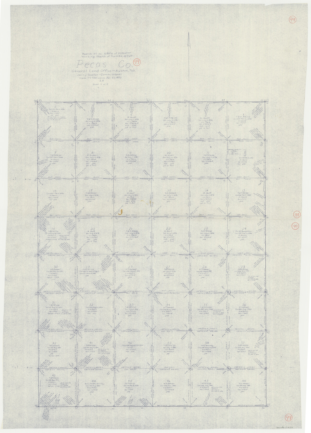
Pecos County Working Sketch 99
-
Map/Doc
71572
-
Collection
General Map Collection
-
Object Dates
4/23/1970 (Creation Date)
-
Counties
Pecos
-
Subjects
Surveying Working Sketch
-
Height x Width
43.4 x 31.2 inches
110.2 x 79.3 cm
-
Scale
1" = 500 varas
Part of: General Map Collection
Hemphill County Working Sketch 34

Print $40.00
- Digital $50.00
Hemphill County Working Sketch 34
1976
Size 33.9 x 64.2 inches
Map/Doc 66129
Lavaca County Working Sketch 8

Print $20.00
- Digital $50.00
Lavaca County Working Sketch 8
1947
Size 14.7 x 15.9 inches
Map/Doc 70361
Coleman County

Print $40.00
- Digital $50.00
Coleman County
1945
Size 54.9 x 37.1 inches
Map/Doc 1803
Baylor County Boundary File 11

Print $26.00
- Digital $50.00
Baylor County Boundary File 11
Size 11.1 x 8.7 inches
Map/Doc 50419
Sterling County

Print $20.00
- Digital $50.00
Sterling County
1971
Size 44.7 x 33.4 inches
Map/Doc 73294
Lampasas County Boundary File 3a

Print $8.00
- Digital $50.00
Lampasas County Boundary File 3a
Size 13.2 x 8.2 inches
Map/Doc 56106
San Patricio County Sketch File 29

Print $10.00
San Patricio County Sketch File 29
1936
Size 11.3 x 8.8 inches
Map/Doc 36111
[Map of the Houston and G. N. R.R. and lands adjacent, from Troupe to the Texas Pacific R.R.]
![64628, [Map of the Houston and G. N. R.R. and lands adjacent, from Troupe to the Texas Pacific R.R.], General Map Collection](https://historictexasmaps.com/wmedia_w700/maps/64628.tif.jpg)
Print $40.00
- Digital $50.00
[Map of the Houston and G. N. R.R. and lands adjacent, from Troupe to the Texas Pacific R.R.]
1873
Size 20.2 x 49.3 inches
Map/Doc 64628
Colorado River, Danevang Sheet

Print $6.00
- Digital $50.00
Colorado River, Danevang Sheet
1940
Size 24.6 x 35.2 inches
Map/Doc 65321
Upton County Rolled Sketch 25

Print $20.00
- Digital $50.00
Upton County Rolled Sketch 25
1941
Size 33.2 x 34.5 inches
Map/Doc 10044
Upshur County Sketch File 5

Print $4.00
- Digital $50.00
Upshur County Sketch File 5
1855
Size 8.3 x 12.9 inches
Map/Doc 38740
Karnes County Sketch File 1

Print $4.00
- Digital $50.00
Karnes County Sketch File 1
Size 8.8 x 10.7 inches
Map/Doc 28545
You may also like
[Blocks R31E-R33E, Townships 12E-14E]
![92041, [Blocks R31E-R33E, Townships 12E-14E], Twichell Survey Records](https://historictexasmaps.com/wmedia_w700/maps/92041-1.tif.jpg)
Print $20.00
- Digital $50.00
[Blocks R31E-R33E, Townships 12E-14E]
Size 22.9 x 21.4 inches
Map/Doc 92041
General Highway Map, Terrell County, Texas

Print $20.00
General Highway Map, Terrell County, Texas
1940
Size 24.9 x 18.4 inches
Map/Doc 79256
Flight Mission No. DQO-2K, Frame 133, Galveston County

Print $20.00
- Digital $50.00
Flight Mission No. DQO-2K, Frame 133, Galveston County
1952
Size 18.7 x 22.5 inches
Map/Doc 85030
El Paso County Sketch File 33

Print $2.00
- Digital $50.00
El Paso County Sketch File 33
1983
Size 9.0 x 14.5 inches
Map/Doc 22128
Hockley County Working Sketch 1

Print $40.00
- Digital $50.00
Hockley County Working Sketch 1
1946
Size 26.0 x 60.9 inches
Map/Doc 66191
Live Oak County Rolled Sketch 10

Print $20.00
- Digital $50.00
Live Oak County Rolled Sketch 10
1983
Size 38.4 x 43.9 inches
Map/Doc 9456
Aransas County Rolled Sketch 31A

Print $20.00
- Digital $50.00
Aransas County Rolled Sketch 31A
1950
Size 25.1 x 42.4 inches
Map/Doc 77499
Presidio County Rolled Sketch 100

Print $20.00
- Digital $50.00
Presidio County Rolled Sketch 100
1954
Size 30.4 x 30.2 inches
Map/Doc 7382
Central & Montgomery

Print $40.00
- Digital $50.00
Central & Montgomery
1941
Size 26.1 x 123.0 inches
Map/Doc 64523
San Antonio - Downtown - Riverwalk

San Antonio - Downtown - Riverwalk
Size 11.8 x 17.9 inches
Map/Doc 94289
Town of Lubbock, Texas and Additions

Print $20.00
Town of Lubbock, Texas and Additions
1935
Size 43.8 x 43.5 inches
Map/Doc 76271
Refugio County Sketch File 9

Print $4.00
- Digital $50.00
Refugio County Sketch File 9
1850
Size 5.5 x 7.6 inches
Map/Doc 35256