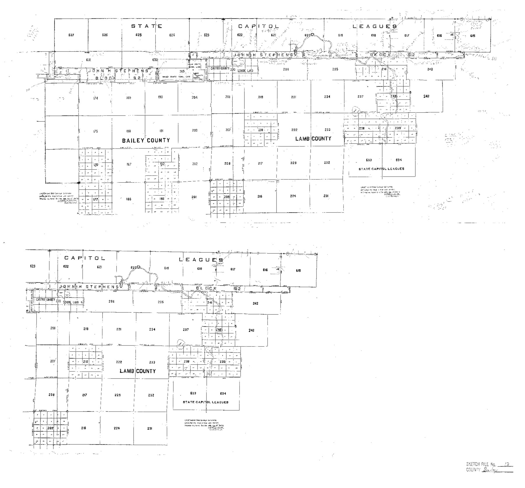
Bailey County Sketch File 13
[Sketch of surveys in Bailey and Lamb Counties]
-
Map/Doc
10888
-
Collection
General Map Collection
-
Object Dates
1912/12/29 (Creation Date)
-
People and Organizations
W.D. Twichell (Surveyor/Engineer)
-
Counties
Bailey Lamb
-
Subjects
Surveying Sketch File
-
Height x Width
19.2 x 20.6 inches
48.8 x 52.3 cm
-
Medium
blueprint/diazo
Part of: General Map Collection
Flight Mission No. CGI-1N, Frame 178, Cameron County

Print $20.00
- Digital $50.00
Flight Mission No. CGI-1N, Frame 178, Cameron County
1955
Size 18.6 x 22.3 inches
Map/Doc 84513
J. De Cordova's Map of the State of Texas Compiled from the records of the General Land Office of the State

Print $20.00
- Digital $50.00
J. De Cordova's Map of the State of Texas Compiled from the records of the General Land Office of the State
1849
Size 34.0 x 31.5 inches
Map/Doc 656
Hall County Boundary File 1

Print $26.00
- Digital $50.00
Hall County Boundary File 1
Size 8.8 x 4.0 inches
Map/Doc 54158
Freestone County Working Sketch 29

Print $20.00
- Digital $50.00
Freestone County Working Sketch 29
1994
Size 36.0 x 45.5 inches
Map/Doc 69271
Liberty County Working Sketch 41

Print $20.00
- Digital $50.00
Liberty County Working Sketch 41
1953
Size 21.4 x 20.8 inches
Map/Doc 70500
Galveston County NRC Article 33.136 Sketch 68

Print $34.00
- Digital $50.00
Galveston County NRC Article 33.136 Sketch 68
2008
Size 24.0 x 36.0 inches
Map/Doc 94840
Railroad Track Map, H&TCRRCo., Falls County, Texas

Print $4.00
- Digital $50.00
Railroad Track Map, H&TCRRCo., Falls County, Texas
1918
Size 11.8 x 18.6 inches
Map/Doc 62836
Starr County Sketch File 22

Print $20.00
- Digital $50.00
Starr County Sketch File 22
1922
Size 16.4 x 35.9 inches
Map/Doc 12331
Webb County Sketch File 13-2

Print $20.00
- Digital $50.00
Webb County Sketch File 13-2
1936
Size 16.4 x 20.3 inches
Map/Doc 12632
Irion County Rolled Sketch 12

Print $40.00
- Digital $50.00
Irion County Rolled Sketch 12
1945
Size 37.5 x 51.9 inches
Map/Doc 75943
Schleicher County

Print $40.00
- Digital $50.00
Schleicher County
1898
Size 35.9 x 53.7 inches
Map/Doc 63027
Baylor County Sketch File 22

Print $10.00
- Digital $50.00
Baylor County Sketch File 22
1913
Size 11.2 x 8.8 inches
Map/Doc 14199
You may also like
Hays County Working Sketch 8

Print $20.00
- Digital $50.00
Hays County Working Sketch 8
1942
Size 27.1 x 30.9 inches
Map/Doc 66082
Kinney County Sketch File 40

Print $6.00
Kinney County Sketch File 40
Size 14.0 x 8.5 inches
Map/Doc 97247
Bastrop County Working Sketch 16

Print $20.00
- Digital $50.00
Bastrop County Working Sketch 16
1998
Size 39.2 x 34.1 inches
Map/Doc 67316
Galveston County Sketch File 3

Print $8.00
- Digital $50.00
Galveston County Sketch File 3
1847
Size 13.3 x 8.2 inches
Map/Doc 23352
Flight Mission No. CRC-3R, Frame 208, Chambers County

Print $20.00
- Digital $50.00
Flight Mission No. CRC-3R, Frame 208, Chambers County
1956
Size 18.6 x 22.3 inches
Map/Doc 84863
Runnels County Rolled Sketch 26

Print $40.00
- Digital $50.00
Runnels County Rolled Sketch 26
1928
Size 55.5 x 25.4 inches
Map/Doc 10312
Nueces County Working Sketch Graphic Index

Print $20.00
- Digital $50.00
Nueces County Working Sketch Graphic Index
1913
Size 24.0 x 32.3 inches
Map/Doc 76655
Edwards County Rolled Sketch JFW1

Print $53.00
- Digital $50.00
Edwards County Rolled Sketch JFW1
1935
Size 10.3 x 15.5 inches
Map/Doc 44398
Flight Mission No. BRA-6M, Frame 89, Jefferson County

Print $20.00
- Digital $50.00
Flight Mission No. BRA-6M, Frame 89, Jefferson County
1953
Size 18.6 x 22.4 inches
Map/Doc 85432
Erath County Working Sketch 15

Print $20.00
- Digital $50.00
Erath County Working Sketch 15
1961
Size 19.8 x 15.4 inches
Map/Doc 69096

[Scripture Addition to the City of Denton]
![90586, [Scripture Addition to the City of Denton], Twichell Survey Records](https://historictexasmaps.com/wmedia_w700/maps/90586-1.tif.jpg)
Print $20.00
- Digital $50.00
[Scripture Addition to the City of Denton]
Size 35.4 x 31.4 inches
Map/Doc 90586