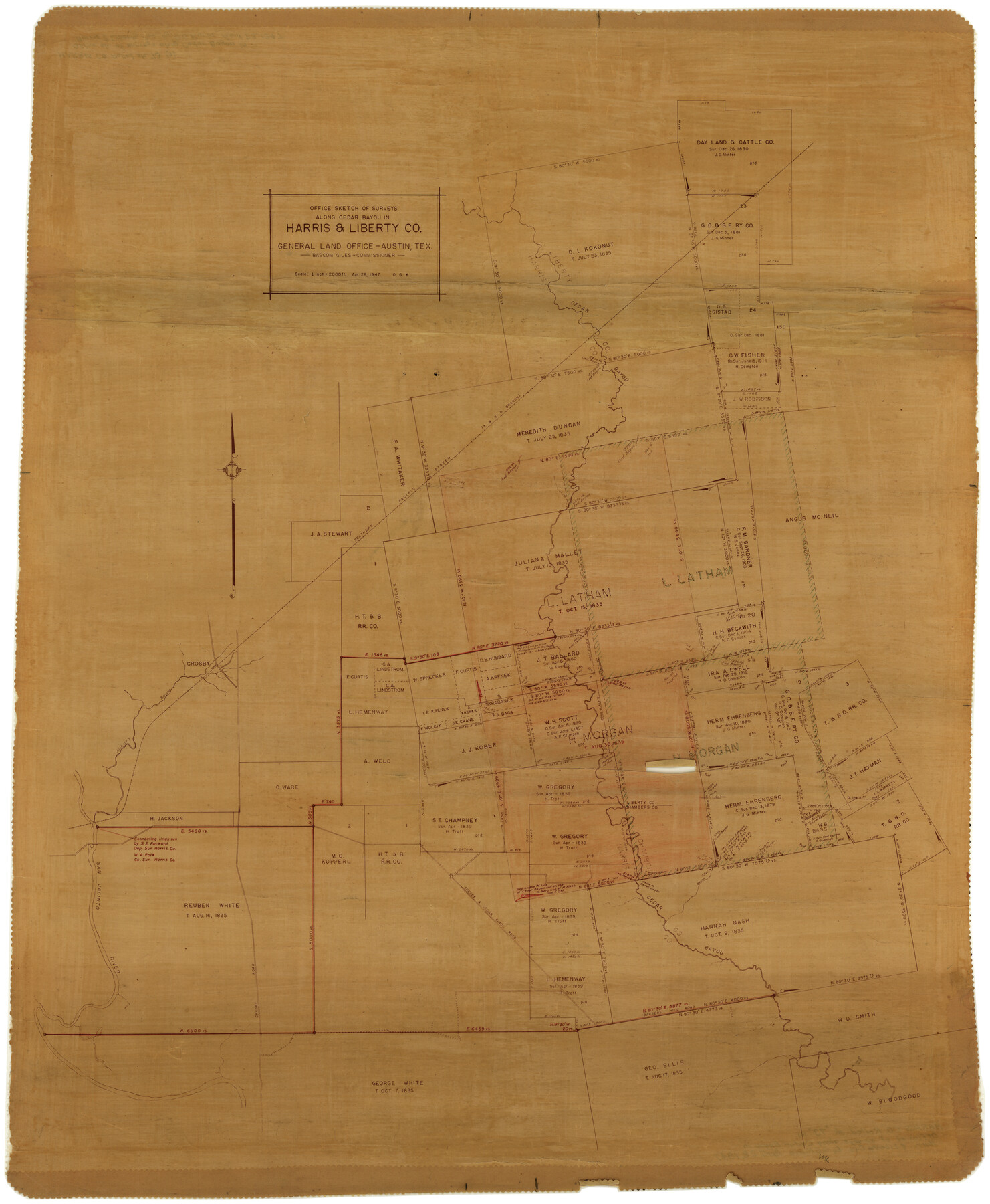
Harris County Rolled Sketch 73
Office sketch of surveys along Cedar Bayou in Harris & Liberty Co.
-
Map/Doc
9133
-
Collection
General Map Collection
-
Object Dates
4/28/1947 (Creation Date)
-
People and Organizations
Otto G. Kurio (Draftsman)
-
Counties
Harris
-
Subjects
Surveying Rolled Sketch
-
Height x Width
41.0 x 33.9 inches
104.1 x 86.1 cm
-
Medium
van dyke/brownline/sepia
-
Scale
1" = 2000 feet
Part of: General Map Collection
Edwards County Boundary File 27d

Print $10.00
- Digital $50.00
Edwards County Boundary File 27d
Size 12.8 x 8.5 inches
Map/Doc 52901
Dallas County Working Sketch 7

Print $20.00
- Digital $50.00
Dallas County Working Sketch 7
1952
Size 17.3 x 23.5 inches
Map/Doc 68573
Live Oak County Working Sketch 14

Print $20.00
- Digital $50.00
Live Oak County Working Sketch 14
1949
Size 27.9 x 42.1 inches
Map/Doc 70599
Ward County Sketch File 10

Print $6.00
- Digital $50.00
Ward County Sketch File 10
1936
Size 11.2 x 8.9 inches
Map/Doc 39635
Angelina County Working Sketch 57

Print $20.00
- Digital $50.00
Angelina County Working Sketch 57
Size 18.0 x 20.3 inches
Map/Doc 78285

Jasper County Sketch File 17

Print $20.00
- Digital $50.00
Jasper County Sketch File 17
1886
Size 27.5 x 35.4 inches
Map/Doc 10505
Map of Hill County

Print $20.00
- Digital $50.00
Map of Hill County
1862
Size 22.1 x 24.7 inches
Map/Doc 3671
Aransas County Sketch File 3

Print $4.00
- Digital $50.00
Aransas County Sketch File 3
Size 8.0 x 12.7 inches
Map/Doc 13104
United States - Gulf Coast Texas - Northern part of Laguna Madre

Print $20.00
- Digital $50.00
United States - Gulf Coast Texas - Northern part of Laguna Madre
1941
Size 18.4 x 24.2 inches
Map/Doc 72936
Austin County Sketch File EF

Print $40.00
- Digital $50.00
Austin County Sketch File EF
1895
Size 15.1 x 17.0 inches
Map/Doc 10879
Sutton County Sketch File 51

Print $6.00
- Digital $50.00
Sutton County Sketch File 51
1947
Size 11.3 x 8.9 inches
Map/Doc 37526
You may also like
A Visit to Texas: Being The Journal of a Traveler Through Those Parts Most Interesting to American Settlers. With Descriptions of Scenery, Habits, & c. &c.

Print $560.00
- Digital $50.00
A Visit to Texas: Being The Journal of a Traveler Through Those Parts Most Interesting to American Settlers. With Descriptions of Scenery, Habits, & c. &c.
1834
Size 8.0 x 5.2 inches
Map/Doc 93849
Crosby County Sketch File 18

Print $26.00
- Digital $50.00
Crosby County Sketch File 18
1905
Size 14.2 x 8.5 inches
Map/Doc 20071
Pecos County Sketch

Print $20.00
- Digital $50.00
Pecos County Sketch
Size 34.2 x 23.2 inches
Map/Doc 92915
Shackelford County Boundary File 3

Print $42.00
- Digital $50.00
Shackelford County Boundary File 3
Size 11.4 x 8.7 inches
Map/Doc 58649
Crockett County Sketch File 100

Print $4.00
- Digital $50.00
Crockett County Sketch File 100
2013
Size 14.0 x 8.5 inches
Map/Doc 93663
Terry County Boundary File 2

Print $10.00
- Digital $50.00
Terry County Boundary File 2
Size 9.1 x 8.8 inches
Map/Doc 59204
Hartley County Sketch File 6

Print $20.00
- Digital $50.00
Hartley County Sketch File 6
Size 30.5 x 25.6 inches
Map/Doc 11698
Harrison County Rolled Sketch 14

Print $20.00
- Digital $50.00
Harrison County Rolled Sketch 14
1968
Size 25.8 x 20.0 inches
Map/Doc 6157
Map of Brown County

Print $20.00
- Digital $50.00
Map of Brown County
1858
Size 25.7 x 25.3 inches
Map/Doc 3336
Harris County Working Sketch 93

Print $20.00
- Digital $50.00
Harris County Working Sketch 93
1977
Size 25.9 x 21.1 inches
Map/Doc 65985
Houston County Sketch File 9

Print $4.00
- Digital $50.00
Houston County Sketch File 9
1857
Size 12.7 x 8.1 inches
Map/Doc 26771
The Official Map of the City of El Paso, State of Texas

Print $20.00
The Official Map of the City of El Paso, State of Texas
1889
Size 41.9 x 46.2 inches
Map/Doc 89618