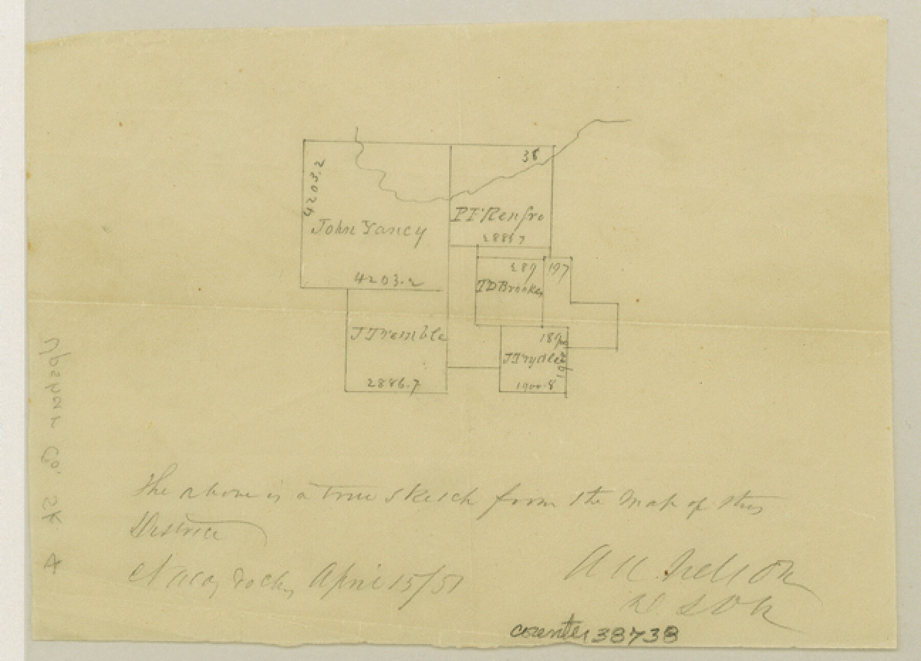
Upshur County Sketch File 4
[Sketch of surveys in the northwest corner of the county]
-
Map/Doc
38738
-
Collection
General Map Collection
-
Object Dates
4/15/1851 (Creation Date)
-
People and Organizations
A.A. Nelson (Surveyor/Engineer)
-
Counties
Upshur
-
Subjects
Surveying Sketch File
-
Height x Width
4.7 x 6.5 inches
11.9 x 16.5 cm
-
Medium
paper, manuscript
Part of: General Map Collection
Andrews County Working Sketch 14

Print $40.00
- Digital $50.00
Andrews County Working Sketch 14
1957
Size 61.6 x 37.1 inches
Map/Doc 67060
Jeff Davis County Working Sketch 39

Print $40.00
- Digital $50.00
Jeff Davis County Working Sketch 39
1981
Size 52.1 x 38.0 inches
Map/Doc 66534
Hunt County Sketch File 13

Print $2.00
- Digital $50.00
Hunt County Sketch File 13
1855
Size 12.4 x 8.1 inches
Map/Doc 27106
Webb County Working Sketch 86

Print $20.00
- Digital $50.00
Webb County Working Sketch 86
1981
Size 44.3 x 37.0 inches
Map/Doc 72453
Map of Tom Green County

Print $20.00
- Digital $50.00
Map of Tom Green County
1892
Size 44.0 x 45.1 inches
Map/Doc 63068
Schleicher County Sketch File 36

Print $20.00
- Digital $50.00
Schleicher County Sketch File 36
1951
Size 15.2 x 21.7 inches
Map/Doc 12309
Comal County Rolled Sketch 3

Print $20.00
- Digital $50.00
Comal County Rolled Sketch 3
1977
Size 19.0 x 17.3 inches
Map/Doc 5538
Calhoun County NRC Article 33.136 Sketch 1

Print $42.00
- Digital $50.00
Calhoun County NRC Article 33.136 Sketch 1
2000
Size 16.8 x 21.7 inches
Map/Doc 61556
Menard County Rolled Sketch 10

Print $20.00
- Digital $50.00
Menard County Rolled Sketch 10
1955
Size 46.7 x 37.7 inches
Map/Doc 9511
Flight Mission No. CRC-2R, Frame 189, Chambers County

Print $20.00
- Digital $50.00
Flight Mission No. CRC-2R, Frame 189, Chambers County
1956
Size 18.6 x 22.4 inches
Map/Doc 84767
Galveston County NRC Article 33.136 Sketch 45

Print $21.00
- Digital $50.00
Galveston County NRC Article 33.136 Sketch 45
2007
Size 18.7 x 23.4 inches
Map/Doc 87365
Map of Shackelford County, North of the Clearfork of the Brazos River Young - South of il Milam - Land District

Print $20.00
- Digital $50.00
Map of Shackelford County, North of the Clearfork of the Brazos River Young - South of il Milam - Land District
1859
Size 24.8 x 19.9 inches
Map/Doc 4027
You may also like
[A. Dubois Survey and vicinity]
![91524, [A. Dubois Survey and vicinity], Twichell Survey Records](https://historictexasmaps.com/wmedia_w700/maps/91524-1.tif.jpg)
Print $3.00
- Digital $50.00
[A. Dubois Survey and vicinity]
Size 11.4 x 14.6 inches
Map/Doc 91524
[Sketch of Part of B. S. & F. Block 9]
![93088, [Sketch of Part of B. S. & F. Block 9], Twichell Survey Records](https://historictexasmaps.com/wmedia_w700/maps/93088-1.tif.jpg)
Print $2.00
- Digital $50.00
[Sketch of Part of B. S. & F. Block 9]
Size 8.0 x 7.9 inches
Map/Doc 93088
Colorado River, Grape Creek Sheet/Proposed Dam Site

Print $4.00
- Digital $50.00
Colorado River, Grape Creek Sheet/Proposed Dam Site
1937
Size 20.1 x 23.8 inches
Map/Doc 65304
Maps & Lists Showing Prison Lands (Oil & Gas) Leased as of June 1955

Digital $50.00
Maps & Lists Showing Prison Lands (Oil & Gas) Leased as of June 1955
1934
Size 30.2 x 35.2 inches
Map/Doc 62877
Rusk County Working Sketch 24

Print $20.00
- Digital $50.00
Rusk County Working Sketch 24
1949
Size 20.2 x 24.7 inches
Map/Doc 63660
Polk County Sketch File 1

Print $4.00
- Digital $50.00
Polk County Sketch File 1
Size 13.0 x 7.9 inches
Map/Doc 34116
Map of Harris County Showing Abandoned Surveys

Print $40.00
- Digital $50.00
Map of Harris County Showing Abandoned Surveys
1938
Size 42.5 x 67.1 inches
Map/Doc 2053
Young County Working Sketch 9

Print $20.00
- Digital $50.00
Young County Working Sketch 9
1921
Size 25.9 x 36.6 inches
Map/Doc 62032
Flight Mission No. CGI-1N, Frame 173, Cameron County

Print $20.00
- Digital $50.00
Flight Mission No. CGI-1N, Frame 173, Cameron County
1955
Size 18.5 x 22.1 inches
Map/Doc 84508
Map Showing a Resurvey of Part of Blk. I, H. &. G. N. Ry. Co. Pecos County, Texas, following field notes copied from Jacob Kuechler's field book of his original survey made in October and November 1876

Print $20.00
- Digital $50.00
Map Showing a Resurvey of Part of Blk. I, H. &. G. N. Ry. Co. Pecos County, Texas, following field notes copied from Jacob Kuechler's field book of his original survey made in October and November 1876
1930
Size 19.2 x 14.4 inches
Map/Doc 91549
Flight Mission No. BRE-1P, Frame 6, Nueces County

Print $20.00
- Digital $50.00
Flight Mission No. BRE-1P, Frame 6, Nueces County
1956
Size 18.2 x 22.1 inches
Map/Doc 86614
Atascosa County Sketch File 3a

Print $6.00
- Digital $50.00
Atascosa County Sketch File 3a
1856
Size 7.1 x 8.8 inches
Map/Doc 13736