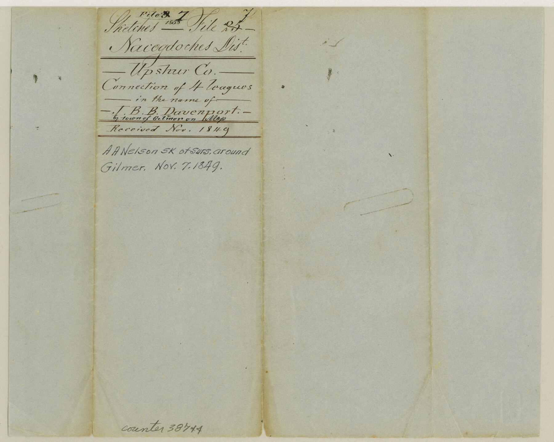
Upshur County Sketch File 7
[Sketch of surveys around Gilmer showing connection of the Davenport four league survey with three one league surveys]
-
Map/Doc
38744
-
Collection
General Map Collection
-
Object Dates
11/7/1849 (Creation Date)
11/1849 (File Date)
-
People and Organizations
A.A. Nelson (Surveyor/Engineer)
-
Counties
Upshur
-
Subjects
Surveying Sketch File
-
Height x Width
8.2 x 10.2 inches
20.8 x 25.9 cm
Part of: General Map Collection
Falls County Sketch File 2

Print $4.00
- Digital $50.00
Falls County Sketch File 2
1854
Size 13.1 x 8.3 inches
Map/Doc 22332
Harris County Rolled Sketch 97

Print $20.00
- Digital $50.00
Harris County Rolled Sketch 97
Size 18.8 x 23.6 inches
Map/Doc 6135
Bosque County Sketch File 12

Print $4.00
- Digital $50.00
Bosque County Sketch File 12
1863
Size 12.7 x 8.2 inches
Map/Doc 14761
Galveston County Working Sketch 11

Print $20.00
- Digital $50.00
Galveston County Working Sketch 11
1967
Size 17.6 x 16.4 inches
Map/Doc 69348
Montague County Working Sketch 27

Print $20.00
- Digital $50.00
Montague County Working Sketch 27
1956
Size 35.8 x 24.9 inches
Map/Doc 71093
Railroad Track Map, H&TCRRCo., Falls County, Texas

Print $4.00
- Digital $50.00
Railroad Track Map, H&TCRRCo., Falls County, Texas
1918
Size 11.7 x 18.5 inches
Map/Doc 62861
Cottle County Working Sketch 24

Print $20.00
- Digital $50.00
Cottle County Working Sketch 24
2014
Size 10.6 x 18.3 inches
Map/Doc 93707
Hamilton County Rolled Sketch 11

Print $20.00
- Digital $50.00
Hamilton County Rolled Sketch 11
Size 20.1 x 14.1 inches
Map/Doc 6060
Flight Mission No. CGI-4N, Frame 179, Cameron County

Print $20.00
- Digital $50.00
Flight Mission No. CGI-4N, Frame 179, Cameron County
1955
Size 18.5 x 22.2 inches
Map/Doc 84682
Sabine and Neches Rivers

Print $20.00
- Digital $50.00
Sabine and Neches Rivers
1976
Size 19.8 x 44.9 inches
Map/Doc 69819
Midland County Sketch File 19

Print $74.00
- Digital $50.00
Midland County Sketch File 19
1952
Size 11.1 x 8.7 inches
Map/Doc 31587
United States - Gulf Coast - Galveston to Rio Grande

Print $20.00
- Digital $50.00
United States - Gulf Coast - Galveston to Rio Grande
1919
Size 26.7 x 18.2 inches
Map/Doc 72744
You may also like
Colton's "New Medium" Map of the State of Texas, the Indian Territory, etc. from the latest & most authentic sources

Print $20.00
- Digital $50.00
Colton's "New Medium" Map of the State of Texas, the Indian Territory, etc. from the latest & most authentic sources
1884
Size 25.4 x 29.5 inches
Map/Doc 96524
General Highway Map, Comal County, Texas

Print $20.00
General Highway Map, Comal County, Texas
1961
Size 18.2 x 25.0 inches
Map/Doc 79417
Flight Mission No. CUG-2P, Frame 79, Kleberg County

Print $20.00
- Digital $50.00
Flight Mission No. CUG-2P, Frame 79, Kleberg County
1956
Size 18.4 x 22.1 inches
Map/Doc 86211
Culberson County Sketch File EM and RJ

Print $24.00
- Digital $50.00
Culberson County Sketch File EM and RJ
Size 13.3 x 8.8 inches
Map/Doc 20157
Brazos Santiago, Texas

Print $20.00
- Digital $50.00
Brazos Santiago, Texas
1900
Size 18.3 x 26.9 inches
Map/Doc 73031
Clay County Sketch File 31

Print $4.00
- Digital $50.00
Clay County Sketch File 31
Size 10.2 x 8.0 inches
Map/Doc 18456
[Block O1, Godair]
![90564, [Block O1, Godair], Twichell Survey Records](https://historictexasmaps.com/wmedia_w700/maps/90564-1.tif.jpg)
Print $20.00
- Digital $50.00
[Block O1, Godair]
Size 21.7 x 14.1 inches
Map/Doc 90564
[Sketch showing unsurveyed land in West Texas as of 1902]
![89937, [Sketch showing unsurveyed land in West Texas as of 1902], Twichell Survey Records](https://historictexasmaps.com/wmedia_w700/maps/89937-1.tif.jpg)
Print $20.00
- Digital $50.00
[Sketch showing unsurveyed land in West Texas as of 1902]
Size 42.0 x 34.0 inches
Map/Doc 89937
Flight Mission No. BRA-16M, Frame 106, Jefferson County

Print $20.00
- Digital $50.00
Flight Mission No. BRA-16M, Frame 106, Jefferson County
1953
Size 18.6 x 22.3 inches
Map/Doc 85718
Flight Mission No. CGI-3N, Frame 120, Cameron County

Print $20.00
- Digital $50.00
Flight Mission No. CGI-3N, Frame 120, Cameron County
1954
Size 18.8 x 22.3 inches
Map/Doc 84593
The Chief Justice County of Harrisburg. January 30, 1837

Print $20.00
The Chief Justice County of Harrisburg. January 30, 1837
2020
Size 17.5 x 21.7 inches
Map/Doc 96049
Webb County Sketch File B3

Print $40.00
- Digital $50.00
Webb County Sketch File B3
1892
Size 8.9 x 4.2 inches
Map/Doc 39658