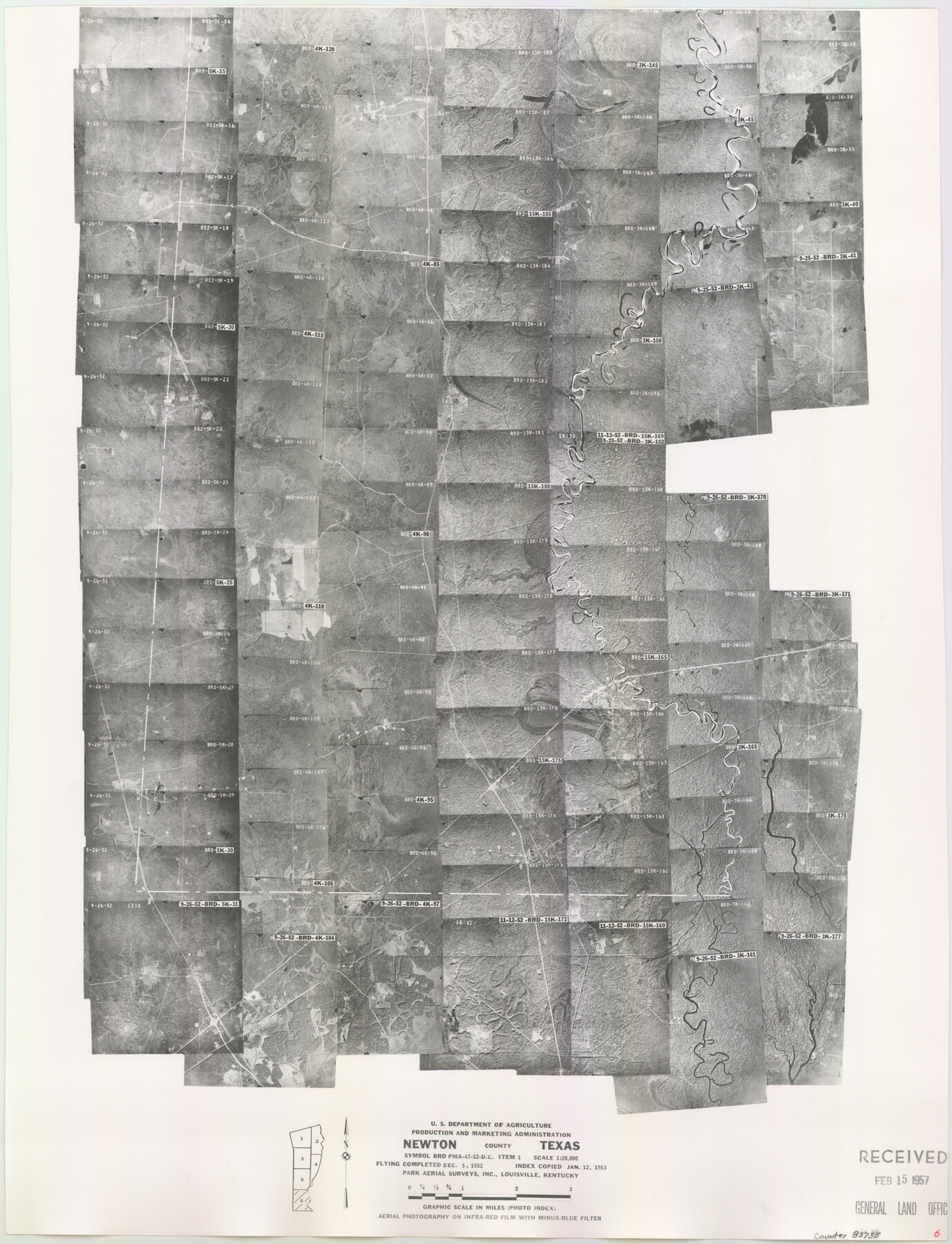
Newton County Aerial Photograph Index Sheet 6
Newton County Aerial Photograph Index 6
-
Map/Doc
83735
-
Collection
General Map Collection
-
Object Dates
1953/1/12 (Creation Date)
-
People and Organizations
U. S. Department of Agriculture (Publisher)
-
Counties
Newton
-
Subjects
Aerial Photograph
-
Height x Width
24.0 x 18.4 inches
61.0 x 46.7 cm
-
Comments
Flying completed December 5, 1952 by Park Aerial Surveys, Inc. of Louisville, Kentucky.
Received in office February 15, 1957.
Part of: General Map Collection
Hamilton County Rolled Sketch 11

Print $20.00
- Digital $50.00
Hamilton County Rolled Sketch 11
Size 20.1 x 14.1 inches
Map/Doc 6060
Duval County Rolled Sketch 45

Print $20.00
- Digital $50.00
Duval County Rolled Sketch 45
1982
Size 36.3 x 24.5 inches
Map/Doc 5760
Brewster County Rolled Sketch 101

Print $20.00
- Digital $50.00
Brewster County Rolled Sketch 101
1944
Size 34.6 x 42.4 inches
Map/Doc 8924
Pecos County Rolled Sketch JAS-1

Print $40.00
- Digital $50.00
Pecos County Rolled Sketch JAS-1
1936
Size 41.8 x 63.8 inches
Map/Doc 76146
Map of Galveston, Turtle & East Bays & portions of the Gulf of Mexico in Chambers & Galveston Counties, Texas showing subdivision for mineral development

Print $40.00
- Digital $50.00
Map of Galveston, Turtle & East Bays & portions of the Gulf of Mexico in Chambers & Galveston Counties, Texas showing subdivision for mineral development
1949
Size 48.9 x 54.8 inches
Map/Doc 2977
Texas Intracoastal Waterway - Laguna Madre - Rincon de San Jose to Chubby Island

Print $20.00
- Digital $50.00
Texas Intracoastal Waterway - Laguna Madre - Rincon de San Jose to Chubby Island
1961
Size 38.0 x 26.7 inches
Map/Doc 73514
Crockett County Sketch File 10

Print $20.00
- Digital $50.00
Crockett County Sketch File 10
Size 14.0 x 12.7 inches
Map/Doc 75924
Coryell County Sketch File 17

Print $4.00
- Digital $50.00
Coryell County Sketch File 17
1854
Size 6.7 x 8.4 inches
Map/Doc 19375
Shelby County

Print $40.00
- Digital $50.00
Shelby County
1897
Size 43.9 x 49.3 inches
Map/Doc 16814
Kinney County Working Sketch 32

Print $20.00
- Digital $50.00
Kinney County Working Sketch 32
1961
Size 32.6 x 42.5 inches
Map/Doc 70214
Crosby County Sketch File 3

Print $36.00
- Digital $50.00
Crosby County Sketch File 3
1885
Size 12.8 x 8.7 inches
Map/Doc 19992
Sutton County Working Sketch Graphic Index, Sheet 2 (Sketches 25 to Most Recent)

Print $40.00
- Digital $50.00
Sutton County Working Sketch Graphic Index, Sheet 2 (Sketches 25 to Most Recent)
1941
Size 41.2 x 55.2 inches
Map/Doc 76706
You may also like
Pecos County Working Sketch 30

Print $20.00
- Digital $50.00
Pecos County Working Sketch 30
1936
Size 27.9 x 27.4 inches
Map/Doc 71502
Yoakum County Working Sketch 1

Print $20.00
- Digital $50.00
Yoakum County Working Sketch 1
1949
Size 18.5 x 19.1 inches
Map/Doc 62023
General Highway Map, Collin County, Texas

Print $20.00
General Highway Map, Collin County, Texas
1939
Size 18.6 x 25.0 inches
Map/Doc 79052
Colorado County Sketch File 35

Print $13.00
- Digital $50.00
Colorado County Sketch File 35
2005
Size 44.0 x 28.0 inches
Map/Doc 83564
Ward County Rolled Sketch 21

Print $20.00
- Digital $50.00
Ward County Rolled Sketch 21
1951
Size 21.1 x 43.3 inches
Map/Doc 8163
Atascosa County Rolled Sketch 26

Print $20.00
- Digital $50.00
Atascosa County Rolled Sketch 26
2013
Size 24.6 x 36.6 inches
Map/Doc 95409
Sutton County Sketch File 49

Print $6.00
- Digital $50.00
Sutton County Sketch File 49
Size 13.6 x 8.9 inches
Map/Doc 37523

Montgomery County Working Sketch 8a

Print $20.00
- Digital $50.00
Montgomery County Working Sketch 8a
1932
Size 17.8 x 20.4 inches
Map/Doc 71114
San Patricio County Rolled Sketch 22

Print $20.00
- Digital $50.00
San Patricio County Rolled Sketch 22
1882
Size 19.3 x 23.9 inches
Map/Doc 7581
Garden City, Tom Green County, Texas, Section 5, Range 4-S Block 33

Print $3.00
- Digital $50.00
Garden City, Tom Green County, Texas, Section 5, Range 4-S Block 33
1886
Size 10.0 x 16.6 inches
Map/Doc 92130
Flight Mission No. DQO-1K, Frame 117, Galveston County

Print $20.00
- Digital $50.00
Flight Mission No. DQO-1K, Frame 117, Galveston County
1952
Size 18.9 x 22.5 inches
Map/Doc 84995