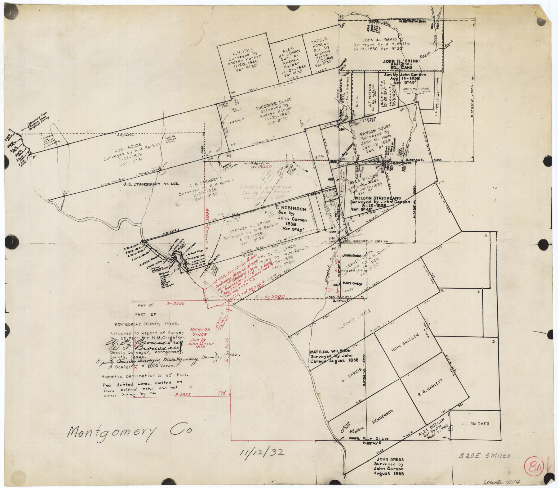
Montgomery County Working Sketch 8a
-
Map/Doc
71114
-
Collection
General Map Collection
-
Object Dates
11/12/1932 (Creation Date)
-
People and Organizations
W.F. Broussard (Surveyor/Engineer)
-
Counties
Montgomery
-
Subjects
Surveying Working Sketch
-
Height x Width
17.8 x 20.4 inches
45.2 x 51.8 cm
-
Scale
1" = 1000 varas
-
Comments
Reverse side has Angelina County Working Sketch 57 (78285).
Part of: General Map Collection
Topographical Map of the Rio Grande, Sheet No. 20

Print $20.00
- Digital $50.00
Topographical Map of the Rio Grande, Sheet No. 20
1912
Map/Doc 89544
Hale County Working Sketch 2

Print $20.00
- Digital $50.00
Hale County Working Sketch 2
1916
Size 13.5 x 13.1 inches
Map/Doc 63322
Floyd County Sketch File 32

Print $8.00
- Digital $50.00
Floyd County Sketch File 32
1952
Size 14.3 x 8.9 inches
Map/Doc 22792
Controlled Mosaic by Jack Amman Photogrammetric Engineers, Inc - Sheet 24

Print $20.00
- Digital $50.00
Controlled Mosaic by Jack Amman Photogrammetric Engineers, Inc - Sheet 24
1954
Size 20.0 x 24.0 inches
Map/Doc 83475
Harris County Rolled Sketch WHW2

Print $20.00
- Digital $50.00
Harris County Rolled Sketch WHW2
Size 15.5 x 14.4 inches
Map/Doc 6148
Medina County Working Sketch 4

Print $40.00
- Digital $50.00
Medina County Working Sketch 4
1945
Size 52.6 x 35.5 inches
Map/Doc 70919
Bexar County Sketch File 52

Print $28.00
- Digital $50.00
Bexar County Sketch File 52
1935
Size 13.5 x 16.8 inches
Map/Doc 14534
Donley County Sketch File B5

Print $20.00
- Digital $50.00
Donley County Sketch File B5
1918
Size 22.5 x 18.4 inches
Map/Doc 11375
Bandera County Working Sketch 49

Print $20.00
- Digital $50.00
Bandera County Working Sketch 49
1983
Size 28.2 x 43.3 inches
Map/Doc 67645
Flight Mission No. DAG-17K, Frame 77, Matagorda County

Print $20.00
- Digital $50.00
Flight Mission No. DAG-17K, Frame 77, Matagorda County
1952
Size 16.7 x 16.3 inches
Map/Doc 86336
Montague County Working Sketch 17

Print $20.00
- Digital $50.00
Montague County Working Sketch 17
1947
Size 22.1 x 30.0 inches
Map/Doc 71083
Haskell County Sketch File 11

Print $6.00
- Digital $50.00
Haskell County Sketch File 11
1886
Size 16.0 x 10.7 inches
Map/Doc 26140
You may also like
Dallas County Working Sketch 5

Print $20.00
- Digital $50.00
Dallas County Working Sketch 5
1941
Size 18.7 x 16.4 inches
Map/Doc 68571
Cochran County Boundary File 6

Print $10.00
- Digital $50.00
Cochran County Boundary File 6
Size 10.4 x 4.3 inches
Map/Doc 51562
Limestone County Rolled Sketch 4

Print $20.00
- Digital $50.00
Limestone County Rolled Sketch 4
1921
Size 35.1 x 35.1 inches
Map/Doc 9573
Val Verde County Working Sketch 77

Print $20.00
- Digital $50.00
Val Verde County Working Sketch 77
1972
Size 45.9 x 38.5 inches
Map/Doc 72212
Crosby County Rolled Sketch 1

Print $20.00
- Digital $50.00
Crosby County Rolled Sketch 1
1950
Size 25.3 x 21.1 inches
Map/Doc 5640
[Cotton Belt, St. Louis Southwestern Railway of Texas, Alignment through Smith County]
![64378, [Cotton Belt, St. Louis Southwestern Railway of Texas, Alignment through Smith County], General Map Collection](https://historictexasmaps.com/wmedia_w700/maps/64378.tif.jpg)
Print $20.00
- Digital $50.00
[Cotton Belt, St. Louis Southwestern Railway of Texas, Alignment through Smith County]
1903
Size 22.3 x 30.1 inches
Map/Doc 64378
Lake Corpus Christi and a city map of Mathis, Texas [Recto]
![94170, Lake Corpus Christi and a city map of Mathis, Texas [Recto], General Map Collection](https://historictexasmaps.com/wmedia_w700/maps/94170.tif.jpg)
Lake Corpus Christi and a city map of Mathis, Texas [Recto]
1984
Size 29.2 x 22.8 inches
Map/Doc 94170

Flight Mission No. DQN-2K, Frame 118, Calhoun County

Print $20.00
- Digital $50.00
Flight Mission No. DQN-2K, Frame 118, Calhoun County
1953
Size 18.5 x 22.2 inches
Map/Doc 84294
Uvalde County Rolled Sketch 18

Print $20.00
- Digital $50.00
Uvalde County Rolled Sketch 18
Size 33.2 x 24.8 inches
Map/Doc 8102
Hamilton County Sketch File 10 1/2

Print $44.00
- Digital $50.00
Hamilton County Sketch File 10 1/2
1876
Size 9.2 x 8.3 inches
Map/Doc 24931
W. Alvin Lloyd's Southern Rail-Road Map

Print $20.00
- Digital $50.00
W. Alvin Lloyd's Southern Rail-Road Map
1863
Size 18.4 x 23.7 inches
Map/Doc 97496