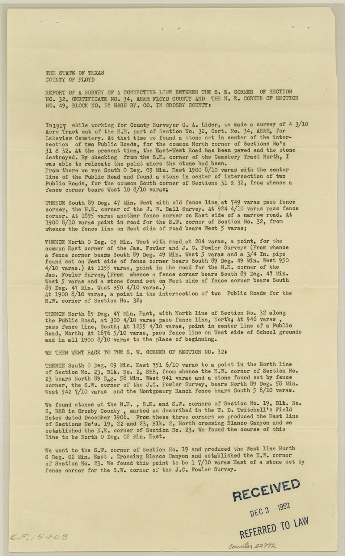
Floyd County Sketch File 32
[Report of a survey of a connecting line between the southeast corner of section 32, certificate 34, A. B. &. M. and the northeast corner of section 49, Block 28, H. & G. N. RR. Co.]
-
Map/Doc
22792
-
Collection
General Map Collection
-
Object Dates
1952/11/24 (Creation Date)
1952/12/3 (File Date)
1927 (Survey Date)
1945 (Survey Date)
-
People and Organizations
W.D. Newell (Surveyor/Engineer)
George A. Lider (Surveyor/Engineer)
W.D. Twichell (Surveyor/Engineer)
George Mayes (Surveyor/Engineer)
-
Counties
Floyd Crosby
-
Subjects
Surveying Sketch File
-
Height x Width
14.3 x 8.9 inches
36.3 x 22.6 cm
-
Medium
paper, print
-
Features
Lakeview Cemetery
Public Road
Montgomery Ranch
Blanco Canyon
Part of: General Map Collection
Calhoun County NRC Article 33.136 Sketch 15

Print $46.00
Calhoun County NRC Article 33.136 Sketch 15
2025
Map/Doc 97428
Webb County Sketch File 6-1

Print $6.00
- Digital $50.00
Webb County Sketch File 6-1
1877
Size 9.8 x 12.7 inches
Map/Doc 39737
San Augustine County Rolled Sketch 1

Print $20.00
- Digital $50.00
San Augustine County Rolled Sketch 1
1946
Size 19.1 x 30.4 inches
Map/Doc 7553
Edwards County Boundary File 27c

Print $29.00
- Digital $50.00
Edwards County Boundary File 27c
Size 12.8 x 8.1 inches
Map/Doc 52896
Flight Mission No. DCL-7C, Frame 137, Kenedy County

Print $20.00
- Digital $50.00
Flight Mission No. DCL-7C, Frame 137, Kenedy County
1943
Size 15.4 x 15.3 inches
Map/Doc 86094
Terrell County Working Sketch 63

Print $20.00
- Digital $50.00
Terrell County Working Sketch 63
1970
Size 37.8 x 35.9 inches
Map/Doc 69584
Harris County Working Sketch 46

Print $20.00
- Digital $50.00
Harris County Working Sketch 46
1942
Size 19.8 x 17.7 inches
Map/Doc 65938

Jack County Sketch File 16

Print $4.00
- Digital $50.00
Jack County Sketch File 16
1877
Size 7.9 x 12.8 inches
Map/Doc 27549
Terrell County Working Sketch 51

Print $40.00
- Digital $50.00
Terrell County Working Sketch 51
1958
Size 63.7 x 43.6 inches
Map/Doc 62144
Gray County Sketch File 3

Print $6.00
- Digital $50.00
Gray County Sketch File 3
1885
Size 12.9 x 8.3 inches
Map/Doc 24415
Shelby County Rolled Sketch 2

Print $20.00
- Digital $50.00
Shelby County Rolled Sketch 2
Size 20.3 x 30.7 inches
Map/Doc 7775
You may also like
Terrell County Rolled Sketch 51A

Print $20.00
- Digital $50.00
Terrell County Rolled Sketch 51A
1957
Size 29.1 x 20.6 inches
Map/Doc 7968
Floyd County Boundary File 3

Print $4.00
- Digital $50.00
Floyd County Boundary File 3
Size 14.4 x 8.9 inches
Map/Doc 53492
Sketch showing county lines of Lynn, Garza, Borden, Scurry

Print $40.00
- Digital $50.00
Sketch showing county lines of Lynn, Garza, Borden, Scurry
1961
Size 23.9 x 79.9 inches
Map/Doc 1719
Flight Mission No. BRA-7M, Frame 187, Jefferson County

Print $20.00
- Digital $50.00
Flight Mission No. BRA-7M, Frame 187, Jefferson County
1953
Size 18.5 x 22.2 inches
Map/Doc 85555
Calcasieu Pass to Sabine Pass
Print $20.00
- Digital $50.00
Calcasieu Pass to Sabine Pass
1946
Size 45.0 x 35.7 inches
Map/Doc 69807
Liberty County Working Sketch 31

Print $20.00
- Digital $50.00
Liberty County Working Sketch 31
1942
Size 23.1 x 42.9 inches
Map/Doc 70490
Hudspeth County Working Sketch 32a

Print $40.00
- Digital $50.00
Hudspeth County Working Sketch 32a
1975
Size 57.4 x 39.3 inches
Map/Doc 66317
San Patricio County Rolled Sketch 54

Print $20.00
- Digital $50.00
San Patricio County Rolled Sketch 54
1995
Size 25.3 x 36.5 inches
Map/Doc 7740
Typus Orbis Terrarum

Print $20.00
- Digital $50.00
Typus Orbis Terrarum
1575
Size 15.2 x 20.8 inches
Map/Doc 96579
Greer County Sketch File 12

Print $20.00
- Digital $50.00
Greer County Sketch File 12
Size 23.6 x 20.1 inches
Map/Doc 11585
Cooke County Working Sketch 21

Print $20.00
- Digital $50.00
Cooke County Working Sketch 21
1959
Size 35.3 x 30.3 inches
Map/Doc 68258
Hutchinson County Rolled Sketch 37A

Print $40.00
- Digital $50.00
Hutchinson County Rolled Sketch 37A
1950
Size 26.0 x 51.1 inches
Map/Doc 9247