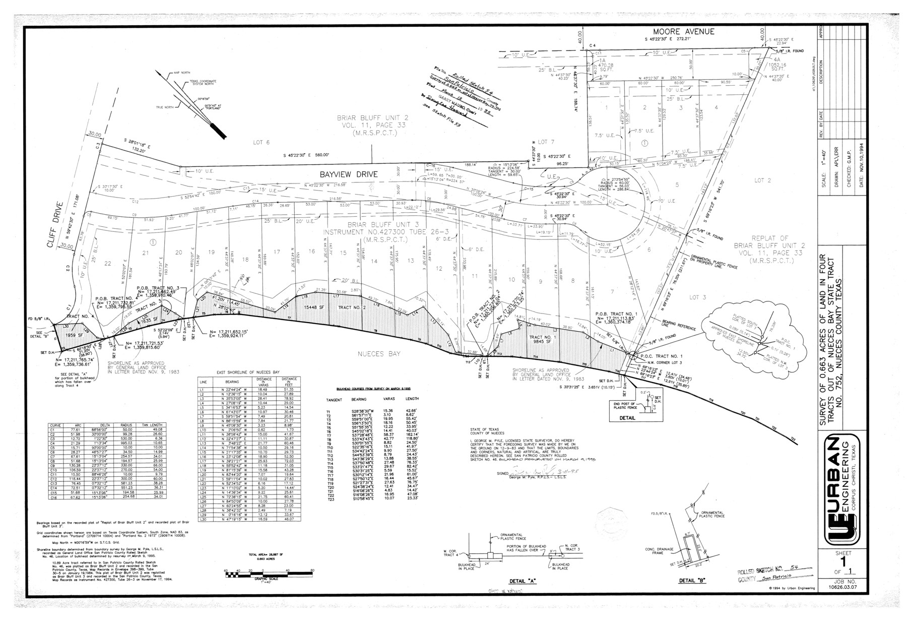
San Patricio County Rolled Sketch 54
Survey of 0.663 acres of land in four tracts out of Nueces Bay State Tract no. 752, Nueces County, Texas
-
Map/Doc
7740
-
Collection
General Map Collection
-
Object Dates
1995/3/9 (Survey Date)
1995/3/13 (File Date)
1995/3/11 (Creation Date)
-
People and Organizations
George M. Pyle (Surveyor/Engineer)
-
Counties
San Patricio Nueces
-
Subjects
Surveying Rolled Sketch
-
Height x Width
25.3 x 36.5 inches
64.3 x 92.7 cm
-
Medium
mylar, print
-
Comments
See San Patricio County Sketch File 53 (36388) for field notes and see San Patricio County Rolled Sketch 46 (7730) for related sketch.
Related maps
San Patricio County Sketch File 53

Print $12.00
- Digital $50.00
San Patricio County Sketch File 53
1995
Size 11.3 x 8.8 inches
Map/Doc 36388
San Patricio County Rolled Sketch 46

Print $20.00
- Digital $50.00
San Patricio County Rolled Sketch 46
1983
Size 19.6 x 25.5 inches
Map/Doc 7730
Part of: General Map Collection
Lipscomb County Boundary File 8

Print $4.00
- Digital $50.00
Lipscomb County Boundary File 8
Size 11.1 x 8.6 inches
Map/Doc 56333
Childress County Sketch File 7

Print $20.00
- Digital $50.00
Childress County Sketch File 7
Size 14.9 x 17.6 inches
Map/Doc 11079
Trinity County Working Sketch Graphic Index

Print $20.00
- Digital $50.00
Trinity County Working Sketch Graphic Index
1946
Size 41.3 x 41.6 inches
Map/Doc 76718
Map of Kerr County

Print $40.00
- Digital $50.00
Map of Kerr County
1895
Size 39.7 x 48.9 inches
Map/Doc 5002
Midland County Working Sketch 6

Print $20.00
- Digital $50.00
Midland County Working Sketch 6
1950
Size 41.2 x 30.9 inches
Map/Doc 70986
Connected Map of Austin's Colony

Print $40.00
- Digital $50.00
Connected Map of Austin's Colony
1837
Size 93.2 x 43.7 inches
Map/Doc 93377
Coke County Rolled Sketch 19

Print $20.00
- Digital $50.00
Coke County Rolled Sketch 19
1954
Size 18.5 x 25.8 inches
Map/Doc 5519
[Northeast portion of Grayson County]
![78364, [Northeast portion of Grayson County], General Map Collection](https://historictexasmaps.com/wmedia_w700/maps/78364.tif.jpg)
Print $20.00
- Digital $50.00
[Northeast portion of Grayson County]
Size 12.0 x 14.0 inches
Map/Doc 78364

Atascosa County

Print $20.00
- Digital $50.00
Atascosa County
1862
Size 29.8 x 25.2 inches
Map/Doc 3248
Williamson County

Print $40.00
- Digital $50.00
Williamson County
1946
Size 38.7 x 56.8 inches
Map/Doc 95676
Pecos County Rolled Sketch 70

Print $40.00
- Digital $50.00
Pecos County Rolled Sketch 70
1929
Size 49.3 x 21.6 inches
Map/Doc 9708
You may also like
Presidio County Rolled Sketch 83B

Print $20.00
- Digital $50.00
Presidio County Rolled Sketch 83B
Size 16.6 x 23.0 inches
Map/Doc 2061
Flight Mission No. BRE-1P, Frame 44, Nueces County

Print $20.00
- Digital $50.00
Flight Mission No. BRE-1P, Frame 44, Nueces County
1956
Size 18.3 x 22.1 inches
Map/Doc 86633
General Highway Map, Hemphill County, Texas

Print $20.00
General Highway Map, Hemphill County, Texas
1961
Size 18.3 x 24.6 inches
Map/Doc 79515
Flight Mission No. CGI-1N, Frame 177, Cameron County

Print $20.00
- Digital $50.00
Flight Mission No. CGI-1N, Frame 177, Cameron County
1955
Size 18.5 x 17.6 inches
Map/Doc 84512
Brewster County Sketch File N-3

Print $6.00
- Digital $50.00
Brewster County Sketch File N-3
1882
Size 8.6 x 7.6 inches
Map/Doc 15589
Cass County Rolled Sketch 6

Print $40.00
- Digital $50.00
Cass County Rolled Sketch 6
1957
Size 40.0 x 61.9 inches
Map/Doc 8586
Webb County Working Sketch 59

Print $20.00
- Digital $50.00
Webb County Working Sketch 59
1960
Size 25.0 x 32.2 inches
Map/Doc 72425
[Surveys in the Jefferson District on the Sabine River]
![325, [Surveys in the Jefferson District on the Sabine River], General Map Collection](https://historictexasmaps.com/wmedia_w700/maps/325.tif.jpg)
Print $2.00
- Digital $50.00
[Surveys in the Jefferson District on the Sabine River]
1841
Size 8.7 x 7.8 inches
Map/Doc 325
Township No. 5 South Range No. 9 West of the Indian Meridian

Print $20.00
- Digital $50.00
Township No. 5 South Range No. 9 West of the Indian Meridian
1874
Size 19.2 x 24.4 inches
Map/Doc 75167
A Map of the British Empire in North America

Print $20.00
- Digital $50.00
A Map of the British Empire in North America
1774
Size 22.1 x 15.1 inches
Map/Doc 93733
Topographical Map of the Rio Grande from Roma to the Gulf of Mexico, Index Map, Sheet No. 1

Print $20.00
- Digital $50.00
Topographical Map of the Rio Grande from Roma to the Gulf of Mexico, Index Map, Sheet No. 1
1912
Map/Doc 89523