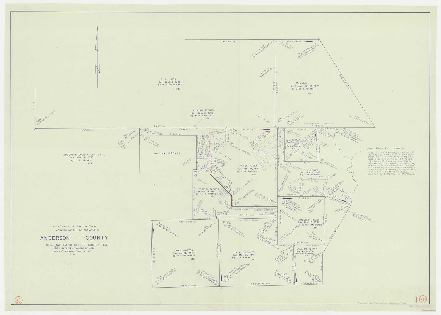
Anderson County Working Sketch 30
-
Map/Doc
67030
-
Collection
General Map Collection
-
Object Dates
3/13/1963 (Creation Date)
-
People and Organizations
Jerry Sadler (GLO Commissioner)
Roy Buckholts (Draftsman)
-
Counties
Anderson
-
Subjects
Surveying Working Sketch
-
Height x Width
29.8 x 41.6 inches
75.7 x 105.7 cm
-
Scale
1" = 300 varas
-
Comments
Surveys located about 12 miles North 80 degrees East of Palestine, Texas.
Part of: General Map Collection
San Patricio County Sketch File 9

Print $2.00
- Digital $50.00
San Patricio County Sketch File 9
1846
Size 8.3 x 8.7 inches
Map/Doc 36039
Burnet County Sketch File 13

Print $4.00
- Digital $50.00
Burnet County Sketch File 13
1848
Size 12.8 x 8.2 inches
Map/Doc 16696
Irion County Rolled Sketch 7

Print $20.00
- Digital $50.00
Irion County Rolled Sketch 7
Size 43.9 x 33.8 inches
Map/Doc 9250
Armstrong County

Print $20.00
- Digital $50.00
Armstrong County
1933
Size 39.3 x 39.4 inches
Map/Doc 77203
Flight Mission No. BRE-1P, Frame 56, Nueces County

Print $20.00
- Digital $50.00
Flight Mission No. BRE-1P, Frame 56, Nueces County
1956
Size 18.5 x 22.4 inches
Map/Doc 86645
Terrell County Sketch File 12

Print $4.00
- Digital $50.00
Terrell County Sketch File 12
1903
Size 5.7 x 8.5 inches
Map/Doc 37922
Bastrop County, From McDade to Austin, Texas, Houston & Texas Central Railroad

Print $20.00
- Digital $50.00
Bastrop County, From McDade to Austin, Texas, Houston & Texas Central Railroad
1939
Size 26.6 x 15.5 inches
Map/Doc 64364
Moore County Sketch File 2

Print $36.00
- Digital $50.00
Moore County Sketch File 2
Size 14.2 x 8.6 inches
Map/Doc 31929
Harris County Sketch File 80b

Print $20.00
- Digital $50.00
Harris County Sketch File 80b
Size 31.5 x 17.2 inches
Map/Doc 11668
Bell County, Milam District

Print $20.00
- Digital $50.00
Bell County, Milam District
1877
Size 23.5 x 28.6 inches
Map/Doc 3293
Flight Mission No. DQN-1K, Frame 139, Calhoun County

Print $20.00
- Digital $50.00
Flight Mission No. DQN-1K, Frame 139, Calhoun County
1953
Size 18.4 x 22.3 inches
Map/Doc 84202
No. 2 Chart of Corpus Christi Pass, Texas

Print $20.00
- Digital $50.00
No. 2 Chart of Corpus Christi Pass, Texas
1878
Size 18.3 x 27.4 inches
Map/Doc 73015
You may also like
The Military History of Texas Map!

The Military History of Texas Map!
1996
Size 24.2 x 35.1 inches
Map/Doc 96827
Flight Mission No. BQR-4K, Frame 66, Brazoria County

Print $20.00
- Digital $50.00
Flight Mission No. BQR-4K, Frame 66, Brazoria County
1952
Size 18.8 x 22.5 inches
Map/Doc 83999
Jim Hogg County Sketch File 3

Print $6.00
- Digital $50.00
Jim Hogg County Sketch File 3
1926
Size 11.0 x 8.6 inches
Map/Doc 28401
Travis County Sketch File 35

Print $2.00
- Digital $50.00
Travis County Sketch File 35
Size 10.8 x 8.3 inches
Map/Doc 38354
Plan of the City of Austin

Print $40.00
- Digital $50.00
Plan of the City of Austin
1840
Size 56.2 x 42.0 inches
Map/Doc 4837
Right of Way and Track Map International & Gt Northern Ry. operated by the International & Gt. Northern Ry. Co., San Antonio Division

Print $40.00
- Digital $50.00
Right of Way and Track Map International & Gt Northern Ry. operated by the International & Gt. Northern Ry. Co., San Antonio Division
1917
Size 25.6 x 58.1 inches
Map/Doc 64587
Burma, Thailand, Indochina and Malayan Federation

Print $3.00
- Digital $50.00
Burma, Thailand, Indochina and Malayan Federation
Size 10.7 x 14.6 inches
Map/Doc 92376
Calhoun County Sketch File 14

Print $20.00
- Digital $50.00
Calhoun County Sketch File 14
1852
Size 22.6 x 16.2 inches
Map/Doc 35980
Newton County Working Sketch 7

Print $20.00
- Digital $50.00
Newton County Working Sketch 7
1936
Size 32.3 x 37.0 inches
Map/Doc 71253
The Mexican Municipality of Colorado. Petition, December 30. 1835

Print $20.00
The Mexican Municipality of Colorado. Petition, December 30. 1835
2020
Size 15.4 x 21.6 inches
Map/Doc 96018
Seagraves Cemetery, Gaines County, Texas

Print $20.00
- Digital $50.00
Seagraves Cemetery, Gaines County, Texas
Size 23.2 x 19.2 inches
Map/Doc 92685
[Atchison, Topeka & Santa Fe from Paisano to south of Plata]
![64711, [Atchison, Topeka & Santa Fe from Paisano to south of Plata], General Map Collection](https://historictexasmaps.com/wmedia_w700/maps/64711-1.tif.jpg)
Print $40.00
- Digital $50.00
[Atchison, Topeka & Santa Fe from Paisano to south of Plata]
Size 34.8 x 123.1 inches
Map/Doc 64711