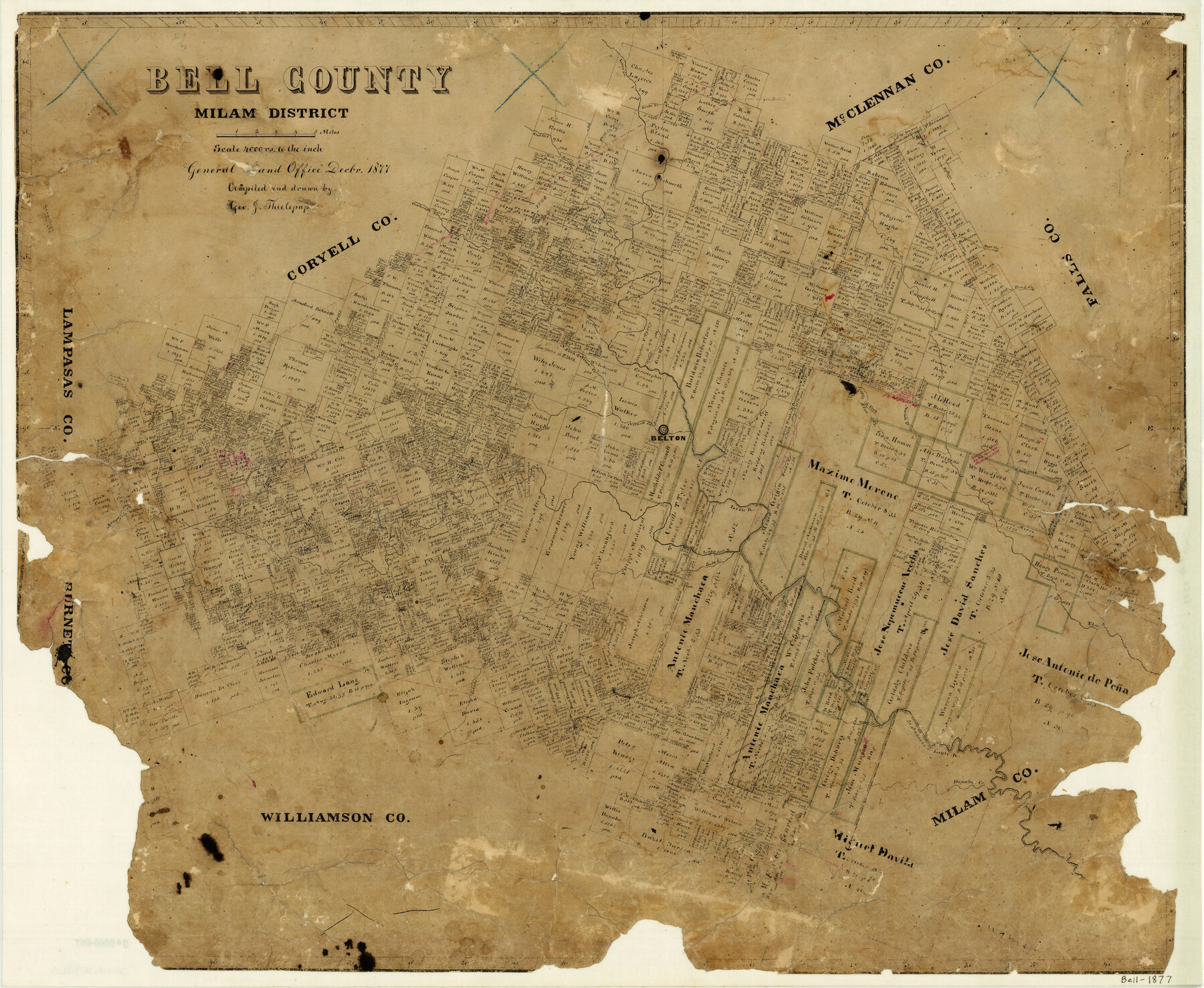
Bell County, Milam District
-
Map/Doc
3293
-
Collection
General Map Collection
-
Object Dates
12/1877 (Creation Date)
-
People and Organizations
George J. Thielepape (Draftsman)
-
Counties
Bell
-
Subjects
County
-
Height x Width
23.5 x 28.6 inches
59.7 x 72.6 cm
-
Features
Trimmier Creek
Darr Creek
Elm Springs Creek
Freeman Creek
Cedar Creek
Cooks Creek
Flint Creek
Donaho Creek
Bear Creek
St. Andreas River
Little River
Salado River
Lampasas River
Leon River
Reese Creek
Leon Creek
Friar Creek
Mitchell Creek
South Fork of Little Elm Creek
Bird Creek
Belton
Noland Creek
North Fork of Noland Creek
Cowhouse Creek
Elm Creek
Pond Creek
Deer Creek
Stampede Creek
Horse Creek
Owl Creek
Part of: General Map Collection
Brazoria County NRC Article 33.136 Sketch 7

Print $21.00
- Digital $50.00
Brazoria County NRC Article 33.136 Sketch 7
2004
Size 23.7 x 33.3 inches
Map/Doc 82907
Loving County

Print $20.00
- Digital $50.00
Loving County
1932
Size 36.0 x 46.7 inches
Map/Doc 95575
Dallas County Working Sketch 7

Print $20.00
- Digital $50.00
Dallas County Working Sketch 7
1952
Size 17.3 x 23.5 inches
Map/Doc 68573
Dawson County Sketch File B

Print $10.00
- Digital $50.00
Dawson County Sketch File B
1917
Size 11.5 x 8.8 inches
Map/Doc 20465
Armstrong County Rolled Sketch 4

Print $40.00
- Digital $50.00
Armstrong County Rolled Sketch 4
1876
Size 37.8 x 70.8 inches
Map/Doc 8426
Val Verde County Rolled Sketch 27

Print $20.00
- Digital $50.00
Val Verde County Rolled Sketch 27
Size 26.0 x 37.9 inches
Map/Doc 8109
Plat of a survey on Padre Island in Willacy County surveyed for South Padre Development Corporation by Claunch and Associates

Print $40.00
- Digital $50.00
Plat of a survey on Padre Island in Willacy County surveyed for South Padre Development Corporation by Claunch and Associates
1973
Size 73.7 x 42.8 inches
Map/Doc 61426
Texas City Channel, Texas, Channel and Turning Basin Dredging - Sheet 5

Print $20.00
- Digital $50.00
Texas City Channel, Texas, Channel and Turning Basin Dredging - Sheet 5
1958
Size 28.2 x 40.9 inches
Map/Doc 61835
Val Verde County Working Sketch 107

Print $20.00
- Digital $50.00
Val Verde County Working Sketch 107
Size 32.8 x 43.5 inches
Map/Doc 72242
Lipscomb County Rolled Sketch 1

Print $40.00
- Digital $50.00
Lipscomb County Rolled Sketch 1
Size 65.0 x 15.8 inches
Map/Doc 9449
Harris County Historic Topographic 19

Print $20.00
- Digital $50.00
Harris County Historic Topographic 19
1915
Size 29.3 x 22.6 inches
Map/Doc 65830
Knox County Rolled Sketch 10

Print $40.00
- Digital $50.00
Knox County Rolled Sketch 10
Size 56.6 x 35.6 inches
Map/Doc 10718
You may also like
Crane County Sketch File 1

Print $20.00
- Digital $50.00
Crane County Sketch File 1
Size 44.8 x 14.6 inches
Map/Doc 10343
Sketch of surveys in Harrison & Marion Cos. showing Caddo Lake & Subdivisions

Print $5.00
- Digital $50.00
Sketch of surveys in Harrison & Marion Cos. showing Caddo Lake & Subdivisions
1955
Size 32.6 x 32.5 inches
Map/Doc 2895
Tom Green County Rolled Sketch 2

Print $20.00
- Digital $50.00
Tom Green County Rolled Sketch 2
Size 17.2 x 26.8 inches
Map/Doc 7992
Bell County Working Sketch 17

Print $20.00
- Digital $50.00
Bell County Working Sketch 17
1983
Size 46.8 x 25.0 inches
Map/Doc 67357
Brewster County Rolled Sketch 104

Print $40.00
- Digital $50.00
Brewster County Rolled Sketch 104
1938
Size 68.3 x 45.3 inches
Map/Doc 8511
Palo Pinto County, Texas

Print $20.00
- Digital $50.00
Palo Pinto County, Texas
1879
Size 17.8 x 19.0 inches
Map/Doc 529
Tom Green County Sketch File 2

Print $4.00
- Digital $50.00
Tom Green County Sketch File 2
Size 9.6 x 7.6 inches
Map/Doc 38161
Jefferson County Sketch File 44

Print $20.00
- Digital $50.00
Jefferson County Sketch File 44
1917
Size 22.8 x 32.9 inches
Map/Doc 11878
Fort Bend County Working Sketch 28

Print $20.00
- Digital $50.00
Fort Bend County Working Sketch 28
1982
Size 15.8 x 20.1 inches
Map/Doc 69234
Houston & Texas Central Railway Through Bastrop County

Print $20.00
- Digital $50.00
Houston & Texas Central Railway Through Bastrop County
1916
Size 21.3 x 41.6 inches
Map/Doc 64419
U.S. Coast and Geodetic First Order Triangulation Stations Geographic Positions Plotted by W.D. Twichell

Digital $50.00
U.S. Coast and Geodetic First Order Triangulation Stations Geographic Positions Plotted by W.D. Twichell
Size 18.0 x 22.7 inches
Map/Doc 92044
Kerr County Rolled Sketch 25

Print $20.00
- Digital $50.00
Kerr County Rolled Sketch 25
Size 24.7 x 31.0 inches
Map/Doc 6505