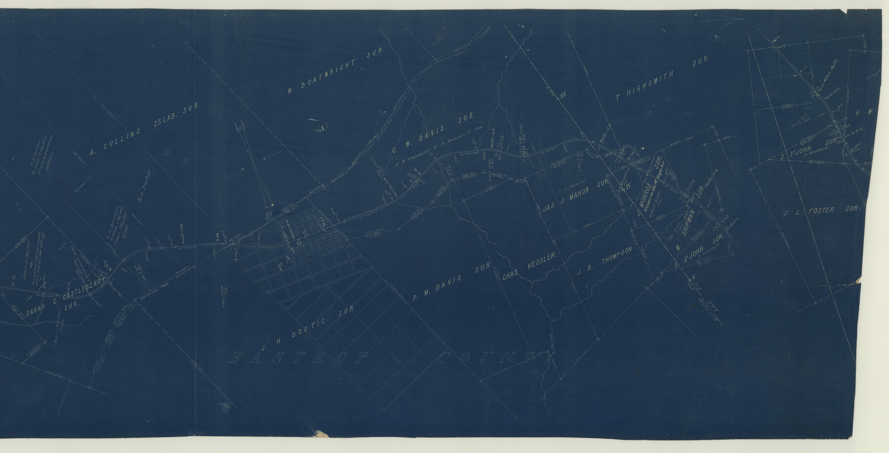
Houston & Texas Central Railway Through Bastrop County
Z-2-108
-
Map/Doc
64419
-
Collection
General Map Collection
-
Object Dates
1916 (Creation Date)
-
Counties
Bastrop Lee
-
Subjects
Railroads
-
Height x Width
21.3 x 41.6 inches
54.1 x 105.7 cm
-
Medium
blueprint/diazo
-
Scale
1"=1000 ft.
-
Comments
Segment 1; see counter no. 64419 for segment 2 and counter no. 64420 for label on reverse side of map.
-
Features
H&TC
San Antonio Road
Paige
Pin Oak Creek
Part of: General Map Collection
Texas-Oklahoma Clara Quadrangle

Print $20.00
- Digital $50.00
Texas-Oklahoma Clara Quadrangle
1918
Size 20.4 x 16.9 inches
Map/Doc 75104

Anderson County Sketch File 16a

Print $4.00
- Digital $50.00
Anderson County Sketch File 16a
1853
Size 12.3 x 8.3 inches
Map/Doc 12786
Flight Mission No. BRA-7M, Frame 35, Jefferson County

Print $20.00
- Digital $50.00
Flight Mission No. BRA-7M, Frame 35, Jefferson County
1953
Size 18.7 x 22.4 inches
Map/Doc 85486
Brooks County Rolled Sketch 25

Print $20.00
- Digital $50.00
Brooks County Rolled Sketch 25
1945
Size 21.6 x 26.4 inches
Map/Doc 5345
Flight Mission No. DQN-3K, Frame 10, Calhoun County

Print $20.00
- Digital $50.00
Flight Mission No. DQN-3K, Frame 10, Calhoun County
1953
Size 18.5 x 22.2 inches
Map/Doc 84342
Flight Mission No. BRA-3M, Frame 119, Jefferson County

Print $20.00
- Digital $50.00
Flight Mission No. BRA-3M, Frame 119, Jefferson County
1953
Size 18.5 x 22.2 inches
Map/Doc 85393
Mason County Working Sketch 13

Print $20.00
- Digital $50.00
Mason County Working Sketch 13
1954
Size 20.0 x 29.9 inches
Map/Doc 70849
Matagorda County Working Sketch 31

Print $20.00
- Digital $50.00
Matagorda County Working Sketch 31
1982
Size 17.2 x 46.9 inches
Map/Doc 70889
PSL Field Notes for Blocks G, L, P, and Q in Cochran and Yoakum Counties and Blocks U, V, W, Y, and Z in Cochran County

PSL Field Notes for Blocks G, L, P, and Q in Cochran and Yoakum Counties and Blocks U, V, W, Y, and Z in Cochran County
Map/Doc 81645
Brazoria County NRC Article 33.136 Sketch 9

Print $24.00
- Digital $50.00
Brazoria County NRC Article 33.136 Sketch 9
2007
Size 24.2 x 34.1 inches
Map/Doc 87929
Current Miscellaneous File 83

Print $2.00
- Digital $50.00
Current Miscellaneous File 83
1936
Size 8.3 x 10.6 inches
Map/Doc 74226
You may also like
[M. B. & B. Blocks A, B and C and various County School Land Leagues]
![90282, [M. B. & B. Blocks A, B and C and various County School Land Leagues], Twichell Survey Records](https://historictexasmaps.com/wmedia_w700/maps/90282-1.tif.jpg)
Print $20.00
- Digital $50.00
[M. B. & B. Blocks A, B and C and various County School Land Leagues]
Size 15.8 x 19.0 inches
Map/Doc 90282
Supplemental Plat of a portion of T. 5S., R. 13W., Indian Mer., Oklahoma

Print $4.00
- Digital $50.00
Supplemental Plat of a portion of T. 5S., R. 13W., Indian Mer., Oklahoma
1922
Size 18.3 x 24.4 inches
Map/Doc 75154
Map of Washburn, Armstrong County, Texas junction of Pan-Handle (Southern Kansas) and Fort Worth & Denver City R'ys

Print $20.00
- Digital $50.00
Map of Washburn, Armstrong County, Texas junction of Pan-Handle (Southern Kansas) and Fort Worth & Denver City R'ys
1888
Map/Doc 97426
Galveston County Sketch File 53

Print $119.00
- Digital $50.00
Galveston County Sketch File 53
1964
Size 14.3 x 8.8 inches
Map/Doc 23527
Kinney County Working Sketch 53

Print $20.00
- Digital $50.00
Kinney County Working Sketch 53
1981
Size 23.7 x 23.0 inches
Map/Doc 70235
Flight Mission No. BQR-9K, Frame 16, Brazoria County

Print $20.00
- Digital $50.00
Flight Mission No. BQR-9K, Frame 16, Brazoria County
1952
Size 18.8 x 22.5 inches
Map/Doc 84045
Karnes County Rolled Sketch 3

Print $20.00
- Digital $50.00
Karnes County Rolled Sketch 3
1959
Size 27.9 x 41.6 inches
Map/Doc 6454
Roberts County Working Sketch 8

Print $20.00
- Digital $50.00
Roberts County Working Sketch 8
1963
Size 21.9 x 26.0 inches
Map/Doc 63534
Liberty County Working Sketch 67

Print $20.00
- Digital $50.00
Liberty County Working Sketch 67
1971
Size 35.3 x 44.5 inches
Map/Doc 70527
Freestone County Working Sketch 4

Print $20.00
- Digital $50.00
Freestone County Working Sketch 4
1921
Size 29.6 x 22.7 inches
Map/Doc 69246
Archer County Sketch File 29

Print $80.00
- Digital $50.00
Archer County Sketch File 29
1888
Size 21.8 x 16.5 inches
Map/Doc 10836
Gulf of Mexico

Print $20.00
- Digital $50.00
Gulf of Mexico
1905
Size 18.3 x 26.8 inches
Map/Doc 72654