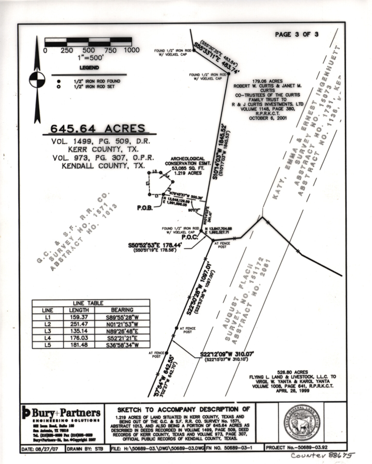
Kerr County State Real Property Sketch 2
A Sketch to Accompany Description of 1.219 Acres of Land Situated in the Gulf, Colorado and Santa Fe Railroad Company Survey No. 1571, A - 1013
-
Map/Doc
88675
-
Collection
General Map Collection
-
Object Dates
2007/8/27 (Creation Date)
-
People and Organizations
Bury + Partners-SA (Publisher)
Bury + Partners-SA (Printer)
STB (Draftsman)
-
Counties
Kerr
-
Subjects
State Real Property
-
Height x Width
10.7 x 8.6 inches
27.2 x 21.8 cm
-
Comments
Surveys located about 19 miles South 38 degrees East of Kerrville, Texas.
Part of: General Map Collection
Briscoe County Sketch File 2a

Print $4.00
- Digital $50.00
Briscoe County Sketch File 2a
Size 6.2 x 7.1 inches
Map/Doc 16415
Morris County Rolled Sketch 1

Print $20.00
- Digital $50.00
Morris County Rolled Sketch 1
1942
Size 23.7 x 24.9 inches
Map/Doc 6835
Brooks County Sketch File 9

Print $2.00
- Digital $50.00
Brooks County Sketch File 9
1988
Size 14.4 x 8.8 inches
Map/Doc 16571
Eastland County Working Sketch 48

Print $20.00
- Digital $50.00
Eastland County Working Sketch 48
1981
Size 35.1 x 25.5 inches
Map/Doc 68829

Nueces County Sketch File 18

Print $4.00
- Digital $50.00
Nueces County Sketch File 18
1874
Size 10.2 x 7.2 inches
Map/Doc 32549
Pecos County Working Sketch 48

Print $20.00
- Digital $50.00
Pecos County Working Sketch 48
1947
Size 35.0 x 27.7 inches
Map/Doc 71520
Hamilton County Sketch File 20

Print $26.00
- Digital $50.00
Hamilton County Sketch File 20
1935
Size 14.4 x 9.1 inches
Map/Doc 24942
Reagan County Rolled Sketch 21

Print $20.00
- Digital $50.00
Reagan County Rolled Sketch 21
1950
Size 32.5 x 42.2 inches
Map/Doc 9815
Lampasas County Sketch File 22

Print $2.00
- Digital $50.00
Lampasas County Sketch File 22
2007
Size 14.0 x 8.5 inches
Map/Doc 93653
Right of Way and Track Map - Houston & Texas Central R.R. operated by the T. and N. O. R.R. Co. - Main Line

Print $40.00
- Digital $50.00
Right of Way and Track Map - Houston & Texas Central R.R. operated by the T. and N. O. R.R. Co. - Main Line
1918
Size 26.0 x 58.1 inches
Map/Doc 82856
Hudspeth County Working Sketch 36

Print $40.00
- Digital $50.00
Hudspeth County Working Sketch 36
1977
Size 63.1 x 37.2 inches
Map/Doc 66321
You may also like
Flight Mission No. CUG-3P, Frame 131, Kleberg County

Print $20.00
- Digital $50.00
Flight Mission No. CUG-3P, Frame 131, Kleberg County
1956
Size 18.7 x 22.4 inches
Map/Doc 86266
Ward County Working Sketch 6

Print $20.00
- Digital $50.00
Ward County Working Sketch 6
1945
Size 23.4 x 24.5 inches
Map/Doc 72312
Flight Mission No. DQO-8K, Frame 50, Galveston County

Print $20.00
- Digital $50.00
Flight Mission No. DQO-8K, Frame 50, Galveston County
1952
Size 18.7 x 22.4 inches
Map/Doc 85157
[B. S. & F. Blk. M10, D. & S. E. RR. Co. Secs. 138 thru 149]
![90133, [B. S. & F. Blk. M10, D. & S. E. RR. Co. Secs. 138 thru 149], Twichell Survey Records](https://historictexasmaps.com/wmedia_w700/maps/90133-1.tif.jpg)
Print $20.00
- Digital $50.00
[B. S. & F. Blk. M10, D. & S. E. RR. Co. Secs. 138 thru 149]
Size 26.4 x 15.5 inches
Map/Doc 90133
Mills County Boundary File 3

Print $30.00
- Digital $50.00
Mills County Boundary File 3
Size 11.0 x 8.6 inches
Map/Doc 57281
[Surveys in the Bexar District along Hondo and Seco Creeks]
![314, [Surveys in the Bexar District along Hondo and Seco Creeks], General Map Collection](https://historictexasmaps.com/wmedia_w700/maps/314.tif.jpg)
Print $3.00
- Digital $50.00
[Surveys in the Bexar District along Hondo and Seco Creeks]
1847
Size 9.3 x 9.9 inches
Map/Doc 314
Martin County Working Sketch 13

Print $40.00
- Digital $50.00
Martin County Working Sketch 13
1971
Size 50.8 x 37.5 inches
Map/Doc 70831
Texas Coordinate File 4

Print $44.00
- Digital $50.00
Texas Coordinate File 4
Size 11.4 x 9.1 inches
Map/Doc 75308
Galveston County NRC Article 33.136 Sketch 93

Digital $50.00
Galveston County NRC Article 33.136 Sketch 93
2020
Map/Doc 97257
[SW Corner of Lynn County]
![92903, [SW Corner of Lynn County], Twichell Survey Records](https://historictexasmaps.com/wmedia_w700/maps/92903-1.tif.jpg)
Print $20.00
- Digital $50.00
[SW Corner of Lynn County]
1954
Size 32.2 x 31.1 inches
Map/Doc 92903
Alexander's Subdivision Tract 2, League 64 Midland County School Land, Cochran County, Texas

Print $20.00
- Digital $50.00
Alexander's Subdivision Tract 2, League 64 Midland County School Land, Cochran County, Texas
1937
Size 19.1 x 22.7 inches
Map/Doc 92518
Flight Mission No. CUG-3P, Frame 45, Kleberg County

Print $20.00
- Digital $50.00
Flight Mission No. CUG-3P, Frame 45, Kleberg County
1956
Size 18.4 x 22.1 inches
Map/Doc 86250