El Paso County Sketch File 28
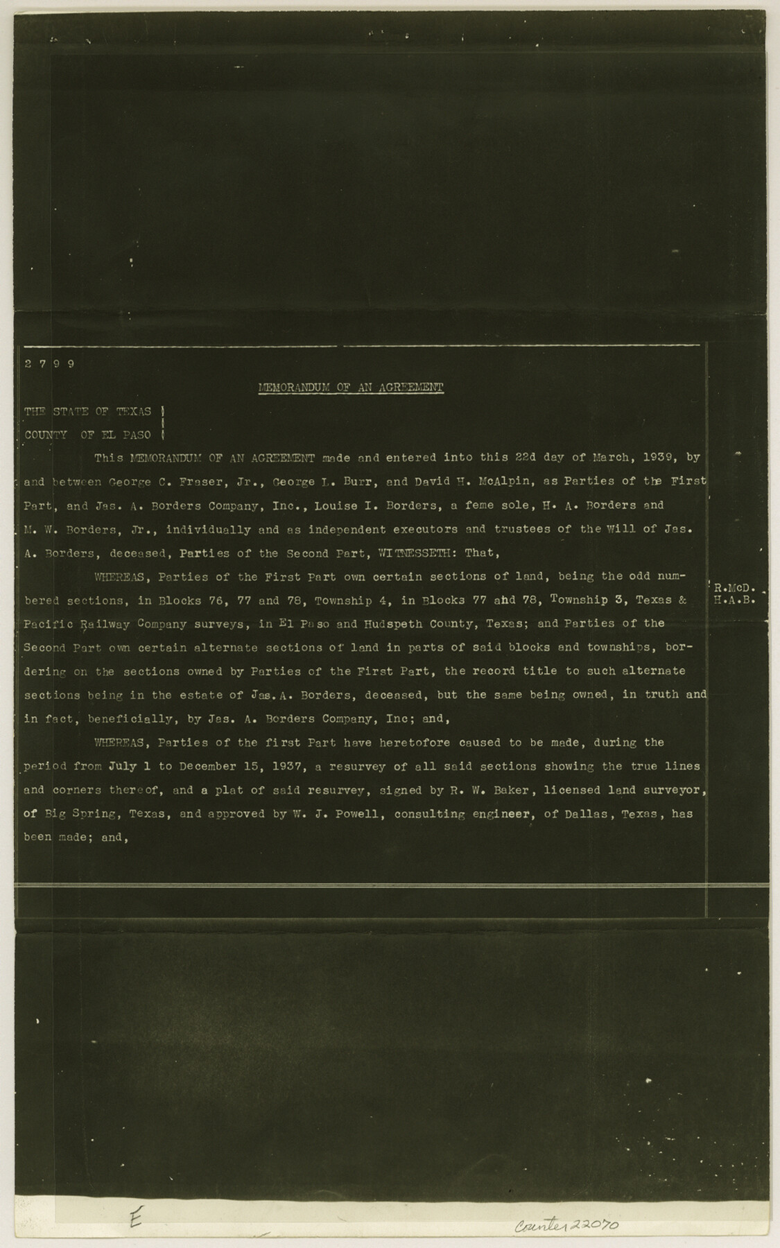
[Memorandum of agreement between Geo. C. Fraser, et al and Jas. A. Borders, et al regarding Blocks 76, 77 and 78, Township 4 and Blocks 77 and 78, Township 3, T. & P. RR. Co.]
-
Map/Doc
22070
-
Collection
General Map Collection
-
Object Dates
1939/3/22 (Creation Date)
1952/7/22 (File Date)
1937/12/15 (Survey Date)
-
People and Organizations
R.W. Baker (Surveyor/Engineer)
-
Counties
El Paso Hudspeth
-
Subjects
Surveying Sketch File
-
Height x Width
15.2 x 9.5 inches
38.6 x 24.1 cm
-
Medium
photostat, negative
Part of: General Map Collection
Harrison County Sketch File 21

Print $20.00
- Digital $50.00
Harrison County Sketch File 21
1892
Size 20.2 x 25.7 inches
Map/Doc 11694
Williamson County Sketch File 13a

Print $4.00
- Digital $50.00
Williamson County Sketch File 13a
1871
Size 8.1 x 13.6 inches
Map/Doc 40330
Fort Bend County Working Sketch 23

Print $20.00
- Digital $50.00
Fort Bend County Working Sketch 23
1978
Size 37.2 x 29.8 inches
Map/Doc 69229
Crane County Working Sketch 28

Print $40.00
- Digital $50.00
Crane County Working Sketch 28
1972
Size 49.4 x 49.1 inches
Map/Doc 68305
Flight Mission No. BRE-1P, Frame 150, Nueces County

Print $20.00
- Digital $50.00
Flight Mission No. BRE-1P, Frame 150, Nueces County
1956
Size 18.6 x 22.1 inches
Map/Doc 86710
Johnson County Working Sketch 14

Print $20.00
- Digital $50.00
Johnson County Working Sketch 14
1974
Size 37.3 x 31.7 inches
Map/Doc 66627
Harris County Rolled Sketch P57

Print $20.00
- Digital $50.00
Harris County Rolled Sketch P57
1929
Size 29.6 x 37.5 inches
Map/Doc 9118
Throckmorton County Rolled Sketch 5A

Print $20.00
- Digital $50.00
Throckmorton County Rolled Sketch 5A
2001
Size 25.2 x 36.0 inches
Map/Doc 76406
Bell County Working Sketch 2

Print $20.00
- Digital $50.00
Bell County Working Sketch 2
1938
Size 25.8 x 28.8 inches
Map/Doc 67342
Dallam County Sketch File 3

Print $4.00
- Digital $50.00
Dallam County Sketch File 3
Size 14.6 x 9.0 inches
Map/Doc 20337
San Saba County Rolled Sketch 2

Print $20.00
- Digital $50.00
San Saba County Rolled Sketch 2
Size 38.9 x 20.7 inches
Map/Doc 7743
Flight Mission No. DQO-8K, Frame 39, Galveston County

Print $20.00
- Digital $50.00
Flight Mission No. DQO-8K, Frame 39, Galveston County
1952
Size 18.7 x 22.4 inches
Map/Doc 85146
You may also like
Jefferson County Rolled Sketch 41

Print $20.00
- Digital $50.00
Jefferson County Rolled Sketch 41
1897
Size 25.1 x 17.8 inches
Map/Doc 6399
Jefferson County Rolled Sketch 27

Print $20.00
- Digital $50.00
Jefferson County Rolled Sketch 27
1948
Size 24.2 x 46.6 inches
Map/Doc 9292

Roberts County Working Sketch 34

Print $20.00
- Digital $50.00
Roberts County Working Sketch 34
1978
Size 26.6 x 22.5 inches
Map/Doc 63560

Map of the District of San Patricio and Nueces

Print $40.00
- Digital $50.00
Map of the District of San Patricio and Nueces
Size 93.8 x 38.4 inches
Map/Doc 93366
Culberson County Sketch File 2a

Print $20.00
- Digital $50.00
Culberson County Sketch File 2a
1849
Size 20.0 x 14.7 inches
Map/Doc 4852
Flight Mission No. DAG-24K, Frame 155, Matagorda County

Print $20.00
- Digital $50.00
Flight Mission No. DAG-24K, Frame 155, Matagorda County
1953
Size 15.9 x 15.8 inches
Map/Doc 86569
Erath County Working Sketch 28

Print $20.00
- Digital $50.00
Erath County Working Sketch 28
1970
Size 31.8 x 31.6 inches
Map/Doc 69109

Madison County Working Sketch 7

Print $20.00
- Digital $50.00
Madison County Working Sketch 7
1982
Size 12.7 x 17.4 inches
Map/Doc 70769
Crosby County

Print $20.00
- Digital $50.00
Crosby County
1927
Size 41.1 x 36.7 inches
Map/Doc 73123