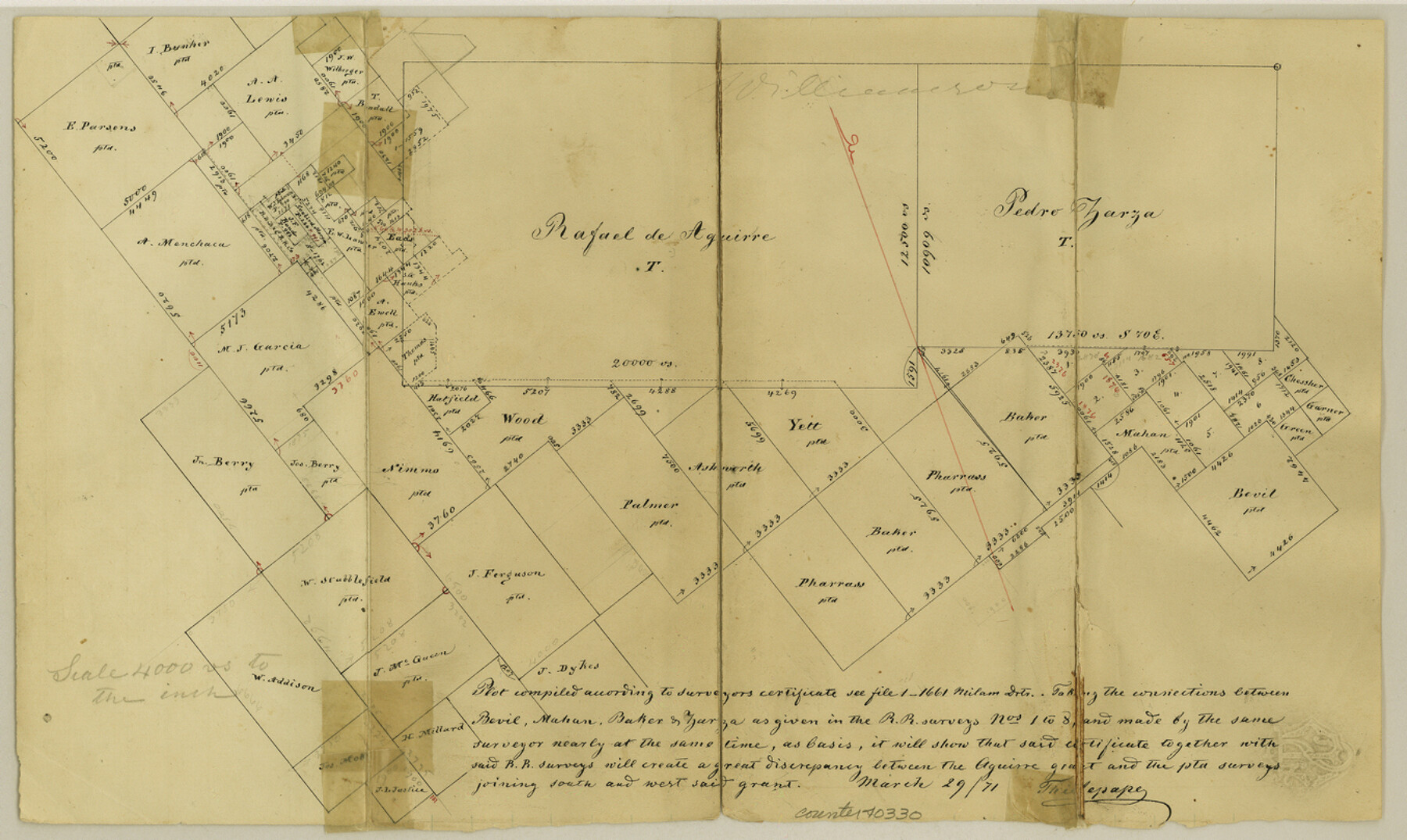
Williamson County Sketch File 13a
[Office sketch around the Rafael de Aguirre grant northeast from Georgetown]
-
Map/Doc
40330
-
Collection
General Map Collection
-
Object Dates
3/29/1871 (Creation Date)
-
People and Organizations
Thielepape (Surveyor/Engineer)
-
Counties
Williamson
-
Subjects
Surveying Sketch File
-
Height x Width
8.1 x 13.6 inches
20.6 x 34.5 cm
-
Medium
paper, manuscript
Part of: General Map Collection
G. C. & S. F., Main Line, Texas, Right of Way map, Rio Vista to Crowley

Print $40.00
- Digital $50.00
G. C. & S. F., Main Line, Texas, Right of Way map, Rio Vista to Crowley
1916
Size 40.2 x 92.0 inches
Map/Doc 64654
Gillespie County Sketch File 4a

Print $40.00
- Digital $50.00
Gillespie County Sketch File 4a
Size 15.8 x 12.8 inches
Map/Doc 24137
Neches River, Blackburn Bridge Dam Site

Print $2.00
- Digital $50.00
Neches River, Blackburn Bridge Dam Site
1938
Size 15.4 x 17.6 inches
Map/Doc 65082
Terrell County Sketch File 41

Print $8.00
- Digital $50.00
Terrell County Sketch File 41
Size 11.3 x 8.8 inches
Map/Doc 38008
Wheeler County Working Sketch 17

Print $20.00
- Digital $50.00
Wheeler County Working Sketch 17
1982
Size 33.5 x 27.7 inches
Map/Doc 72506
Young County Rolled Sketch 13

Print $20.00
- Digital $50.00
Young County Rolled Sketch 13
1966
Size 24.8 x 16.9 inches
Map/Doc 8301
Rio Grande, Raymondville Sheet

Print $20.00
- Digital $50.00
Rio Grande, Raymondville Sheet
1925
Size 43.7 x 17.8 inches
Map/Doc 65127

Dickens County Sketch File E

Print $8.00
- Digital $50.00
Dickens County Sketch File E
Size 11.3 x 8.7 inches
Map/Doc 20843
A Map of the Cotton Kingdom and its Dependencies in America

Print $20.00
- Digital $50.00
A Map of the Cotton Kingdom and its Dependencies in America
1861
Size 12.2 x 18.6 inches
Map/Doc 96573
Frio County Working Sketch 27

Print $20.00
- Digital $50.00
Frio County Working Sketch 27
Size 25.3 x 36.8 inches
Map/Doc 78193
Flight Mission No. DAH-17M, Frame 26, Orange County

Print $20.00
- Digital $50.00
Flight Mission No. DAH-17M, Frame 26, Orange County
1953
Size 18.3 x 22.3 inches
Map/Doc 86889
You may also like
[H. & T. C. RR. Company Block 47, Sections 46, 47, 48, and 49]
![91220, [H. & T. C. RR. Company Block 47, Sections 46, 47, 48, and 49], Twichell Survey Records](https://historictexasmaps.com/wmedia_w700/maps/91220-1.tif.jpg)
Print $3.00
- Digital $50.00
[H. & T. C. RR. Company Block 47, Sections 46, 47, 48, and 49]
Size 9.4 x 11.4 inches
Map/Doc 91220
Hood County Working Sketch 16

Print $40.00
- Digital $50.00
Hood County Working Sketch 16
1987
Size 45.2 x 71.4 inches
Map/Doc 66210
Liberty County Sketch File 19

Print $6.00
- Digital $50.00
Liberty County Sketch File 19
1859
Size 13.6 x 9.4 inches
Map/Doc 29923
Gonzales County

Print $20.00
- Digital $50.00
Gonzales County
1880
Size 26.3 x 24.0 inches
Map/Doc 4550
General Highway Map, Fort Bend County, Texas

Print $20.00
General Highway Map, Fort Bend County, Texas
1961
Size 18.1 x 24.5 inches
Map/Doc 79469
La Salle County Sketch File 19

Print $32.00
- Digital $50.00
La Salle County Sketch File 19
1885
Size 14.2 x 8.7 inches
Map/Doc 29509

Lipscomb County Working Sketch 4

Print $40.00
- Digital $50.00
Lipscomb County Working Sketch 4
1974
Size 51.7 x 43.8 inches
Map/Doc 70580
Brazos River Conservation and Reclamation District Official Boundary Line Survey

Print $20.00
- Digital $50.00
Brazos River Conservation and Reclamation District Official Boundary Line Survey
Size 36.6 x 24.6 inches
Map/Doc 90128
Cottle County Working Sketch 17

Print $20.00
- Digital $50.00
Cottle County Working Sketch 17
1975
Size 32.5 x 34.1 inches
Map/Doc 68327
Zapata County Sketch File 6

Print $22.00
- Digital $50.00
Zapata County Sketch File 6
1913
Size 22.1 x 32.7 inches
Map/Doc 12720
English Field Notes of the Spanish Archives - Book S

English Field Notes of the Spanish Archives - Book S
1835
Map/Doc 96543