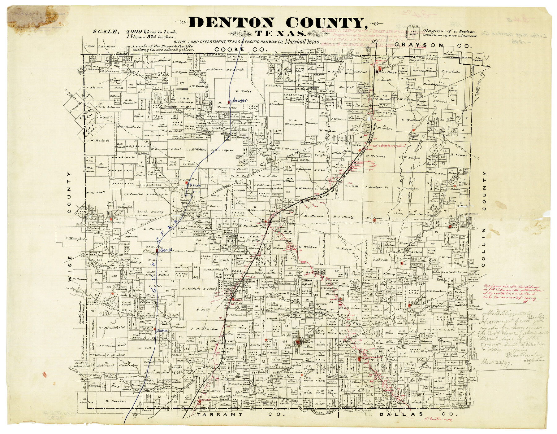
Denton County Texas
Denton County Sketch File 34a
-
Map/Doc
4530
-
Collection
General Map Collection
-
Object Dates
1896 (Creation Date)
-
People and Organizations
Texas and Pacific Railway Company, Marshall (Publisher)
W.H. Abrams (Surveyor/Engineer)
-
Counties
Denton
-
Subjects
County
-
Height x Width
18.4 x 31.6 inches
46.7 x 80.3 cm
-
Comments
Received in office November 20, 1896.
To view the letter filed with this sketch, click the "Download PDF" link above.
Part of: General Map Collection
Atascosa County Working Sketch 4

Print $20.00
- Digital $50.00
Atascosa County Working Sketch 4
1913
Size 16.8 x 15.0 inches
Map/Doc 67199
Newton County Sketch File 13

Print $22.00
- Digital $50.00
Newton County Sketch File 13
Size 8.1 x 12.7 inches
Map/Doc 32386

Calhoun County NRC Article 33.136 Sketch 7

Print $63.00
- Digital $50.00
Calhoun County NRC Article 33.136 Sketch 7
2016
Size 17.1 x 21.8 inches
Map/Doc 94867
Real County Sketch File 5

Print $20.00
- Digital $50.00
Real County Sketch File 5
Size 16.9 x 20.9 inches
Map/Doc 12228
Chambers County Working Sketch 18

Print $20.00
- Digital $50.00
Chambers County Working Sketch 18
1965
Size 39.8 x 29.2 inches
Map/Doc 68001
Duval County Rolled Sketch 51

Print $20.00
- Digital $50.00
Duval County Rolled Sketch 51
Size 19.1 x 16.9 inches
Map/Doc 5765
Wise County Rolled Sketch 8

Print $20.00
- Digital $50.00
Wise County Rolled Sketch 8
Size 24.0 x 36.0 inches
Map/Doc 93554
Williamson County Sketch File 3

Print $24.00
- Digital $50.00
Williamson County Sketch File 3
1853
Size 13.0 x 8.2 inches
Map/Doc 40301
DeWitt County Working Sketch 3

Print $20.00
- Digital $50.00
DeWitt County Working Sketch 3
1957
Size 35.5 x 44.6 inches
Map/Doc 68593
Knox County Rolled Sketch 15

Print $40.00
- Digital $50.00
Knox County Rolled Sketch 15
1892
Size 21.9 x 54.8 inches
Map/Doc 10667
Flight Mission No. CUG-3P, Frame 22, Kleberg County

Print $20.00
- Digital $50.00
Flight Mission No. CUG-3P, Frame 22, Kleberg County
1956
Size 18.5 x 22.1 inches
Map/Doc 86232
You may also like
Swisher County

Print $20.00
- Digital $50.00
Swisher County
1941
Size 44.7 x 38.5 inches
Map/Doc 95648
Crosby County Sketch File 16

Print $20.00
- Digital $50.00
Crosby County Sketch File 16
1904
Size 31.7 x 9.6 inches
Map/Doc 11251
Right of Way and Track Map, Galveston, Harrisburg & San Antonio Ry. operated by the T. & N. O. R.R. Co., Victoria Division, Rosenberg to Beeville

Print $40.00
- Digital $50.00
Right of Way and Track Map, Galveston, Harrisburg & San Antonio Ry. operated by the T. & N. O. R.R. Co., Victoria Division, Rosenberg to Beeville
1918
Size 24.4 x 57.9 inches
Map/Doc 76158
Presidio County Rolled Sketch 105B

Print $20.00
- Digital $50.00
Presidio County Rolled Sketch 105B
Size 46.5 x 36.5 inches
Map/Doc 9789
Gregg County Working Sketch 14

Print $20.00
- Digital $50.00
Gregg County Working Sketch 14
1941
Size 29.7 x 39.5 inches
Map/Doc 63281
Stephens County Working Sketch 3

Print $3.00
- Digital $50.00
Stephens County Working Sketch 3
1919
Size 11.3 x 9.9 inches
Map/Doc 63946
[Sketch of Norwood's Homestead]
![89646, [Sketch of Norwood's Homestead], Twichell Survey Records](https://historictexasmaps.com/wmedia_w700/maps/89646-1.tif.jpg)
Print $40.00
- Digital $50.00
[Sketch of Norwood's Homestead]
Size 31.8 x 49.7 inches
Map/Doc 89646
Flight Mission No. DAG-24K, Frame 150, Matagorda County

Print $20.00
- Digital $50.00
Flight Mission No. DAG-24K, Frame 150, Matagorda County
1953
Size 18.5 x 22.2 inches
Map/Doc 86564
General Highway Map, Dallam County, Hartley County, Texas

Print $20.00
General Highway Map, Dallam County, Hartley County, Texas
1940
Size 18.3 x 25.1 inches
Map/Doc 79065
Brazoria County Sketch File 54

Print $8.00
- Digital $50.00
Brazoria County Sketch File 54
1838
Size 13.4 x 8.2 inches
Map/Doc 15323
Map showing the resurvey of Block M24 T. C. R.R. Co. in Hutchinson County, Texas

Print $20.00
- Digital $50.00
Map showing the resurvey of Block M24 T. C. R.R. Co. in Hutchinson County, Texas
Size 28.8 x 30.8 inches
Map/Doc 76178
Howard County Working Sketch 10

Print $20.00
- Digital $50.00
Howard County Working Sketch 10
1962
Size 24.4 x 26.1 inches
Map/Doc 66278