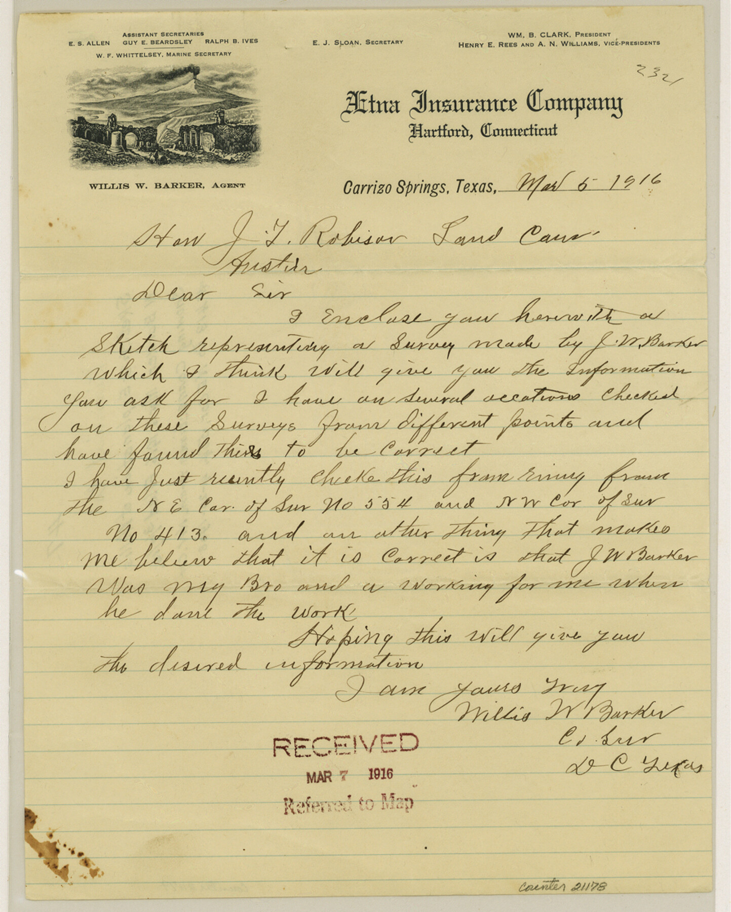
Dimmit County Sketch File 47
[Sketch and explanations showing connections from northwest corner of 413 to northeast corner of 554]
-
Map/Doc
21178
-
Collection
General Map Collection
-
Object Dates
1908/4/20 (Creation Date)
1916/3/7 (File Date)
-
People and Organizations
J.W. Barker (Surveyor/Engineer)
-
Counties
Dimmit
-
Subjects
Surveying Sketch File
-
Height x Width
11.2 x 9.0 inches
28.4 x 22.9 cm
-
Medium
multi-page, multi-format
-
Features
[Road to] Carrizo Springs
Encinal Public Road
Part of: General Map Collection
Texas 1972 Official Highway Travel Map

Digital $50.00
Texas 1972 Official Highway Travel Map
Size 28.2 x 36.4 inches
Map/Doc 94314
Calhoun County Rolled Sketch 33

Print $73.00
- Digital $50.00
Calhoun County Rolled Sketch 33
1979
Size 10.0 x 15.2 inches
Map/Doc 43687
Presidio County Sketch File 58

Print $40.00
- Digital $50.00
Presidio County Sketch File 58
1933
Size 14.7 x 14.4 inches
Map/Doc 34635
Sulphur River, Talco Sheet

Print $20.00
- Digital $50.00
Sulphur River, Talco Sheet
1917
Size 12.5 x 25.5 inches
Map/Doc 78336
Castro County Sketch File 17

Print $20.00
- Digital $50.00
Castro County Sketch File 17
1981
Size 14.8 x 25.7 inches
Map/Doc 11063
Orange County Sketch File 39

Print $20.00
- Digital $50.00
Orange County Sketch File 39
1964
Size 24.2 x 27.9 inches
Map/Doc 12127
Flight Mission No. DQO-3K, Frame 31, Galveston County

Print $20.00
- Digital $50.00
Flight Mission No. DQO-3K, Frame 31, Galveston County
1952
Size 18.9 x 22.5 inches
Map/Doc 85072
[Surveys in the Bexar District along the Guadalupe River and Cibolo Creek]
![3169, [Surveys in the Bexar District along the Guadalupe River and Cibolo Creek], General Map Collection](https://historictexasmaps.com/wmedia_w700/maps/3169.tif.jpg)
Print $20.00
- Digital $50.00
[Surveys in the Bexar District along the Guadalupe River and Cibolo Creek]
1846
Size 9.6 x 18.3 inches
Map/Doc 3169
La Salle County Sketch File 29a

Print $22.00
- Digital $50.00
La Salle County Sketch File 29a
1886
Size 8.9 x 12.5 inches
Map/Doc 29563
Brooks County Working Sketch 18

Print $20.00
- Digital $50.00
Brooks County Working Sketch 18
1981
Size 20.6 x 32.4 inches
Map/Doc 67802
Medina County Working Sketch 15

Print $20.00
- Digital $50.00
Medina County Working Sketch 15
1974
Size 26.2 x 18.7 inches
Map/Doc 70930
Fayette County Working Sketch 1

Print $20.00
- Digital $50.00
Fayette County Working Sketch 1
1949
Size 25.4 x 18.0 inches
Map/Doc 69165
You may also like
The Republic County of Bastrop. May 24, 1838

Print $20.00
The Republic County of Bastrop. May 24, 1838
2020
Size 17.8 x 21.7 inches
Map/Doc 96090
Lubbock County Boundary File 4

Print $4.00
- Digital $50.00
Lubbock County Boundary File 4
Size 11.2 x 8.8 inches
Map/Doc 56491
General Highway Map, Hemphill County, Texas

Print $20.00
General Highway Map, Hemphill County, Texas
1961
Size 18.3 x 24.6 inches
Map/Doc 79515
Township No. 1 North Range No. 25 West of the Indian Meridian

Print $20.00
- Digital $50.00
Township No. 1 North Range No. 25 West of the Indian Meridian
1874
Size 19.4 x 24.7 inches
Map/Doc 75172
Liberty County Sketch File 54

Print $54.00
- Digital $50.00
Liberty County Sketch File 54
1889
Size 14.3 x 8.7 inches
Map/Doc 30022
Coryell County Working Sketch 1

Print $20.00
- Digital $50.00
Coryell County Working Sketch 1
1906
Size 14.7 x 12.9 inches
Map/Doc 68208
Map of Rotan Fisher County, Texas

Print $20.00
- Digital $50.00
Map of Rotan Fisher County, Texas
1926
Size 32.2 x 36.5 inches
Map/Doc 93231
Upton County Sketch File 42

Print $3.00
- Digital $50.00
Upton County Sketch File 42
1986
Size 10.9 x 17.0 inches
Map/Doc 38919
Rockwall County Boundary File 9

Print $8.00
- Digital $50.00
Rockwall County Boundary File 9
Size 15.9 x 9.0 inches
Map/Doc 58433
Howard County Boundary File 4b

Print $24.00
- Digital $50.00
Howard County Boundary File 4b
Size 11.3 x 8.9 inches
Map/Doc 55168

Yoakum County Rolled Sketch 6

Print $20.00
- Digital $50.00
Yoakum County Rolled Sketch 6
Size 18.7 x 34.6 inches
Map/Doc 8291