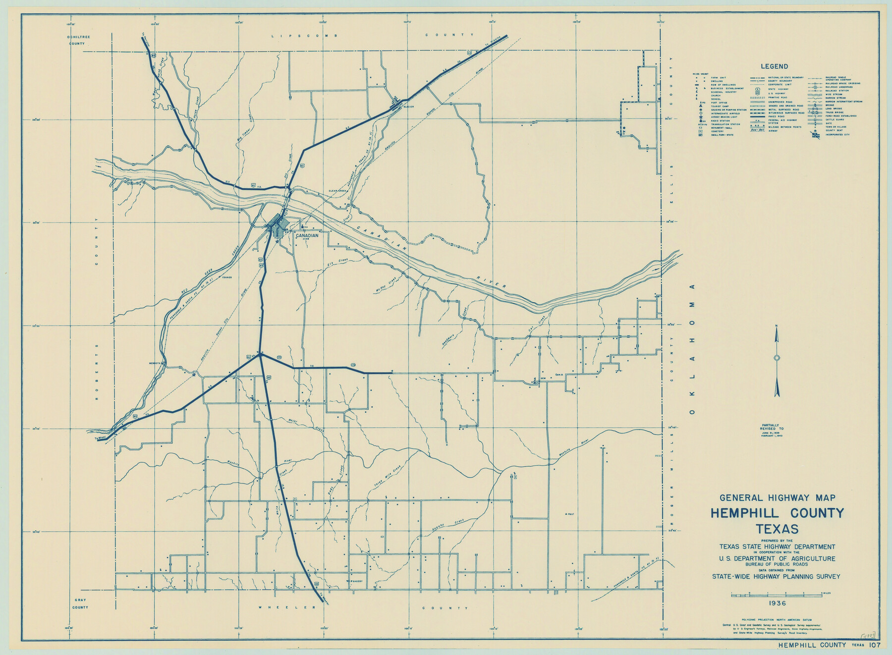
General Highway Map, Hemphill County, Texas
-
Map/Doc
79124
-
Collection
Texas State Library and Archives
-
Object Dates
1940 (Creation Date)
-
People and Organizations
Texas State Highway Department (Publisher)
-
Counties
Hemphill
-
Subjects
County
-
Height x Width
18.2 x 24.8 inches
46.2 x 63.0 cm
-
Comments
Prints available courtesy of the Texas State Library and Archives.
More info can be found here: TSLAC Map 04889
Part of: Texas State Library and Archives


Oil and Gas Fields in the State of Texas

Print $40.00
Oil and Gas Fields in the State of Texas
1927
Size 58.0 x 38.0 inches
Map/Doc 76304
Principal Highways of the Southwest with particular reference to New Mexico, Oklahoma, Texas, Arkansas and Louisiana

Print $20.00
Principal Highways of the Southwest with particular reference to New Mexico, Oklahoma, Texas, Arkansas and Louisiana
1933
Size 24.3 x 18.4 inches
Map/Doc 76302
Topographisch-geognostische Karte von Texas

Print $20.00
Topographisch-geognostische Karte von Texas
1849
Size 23.8 x 21.1 inches
Map/Doc 76241
General Highway Map. Detail of Cities and Towns in Williamson County, Texas [Round Rock, Taylor, Georgetown]
![79714, General Highway Map. Detail of Cities and Towns in Williamson County, Texas [Round Rock, Taylor, Georgetown], Texas State Library and Archives](https://historictexasmaps.com/wmedia_w700/maps/79714.tif.jpg)
Print $20.00
General Highway Map. Detail of Cities and Towns in Williamson County, Texas [Round Rock, Taylor, Georgetown]
1961
Size 18.2 x 24.8 inches
Map/Doc 79714
General Highway Map, Ward County, Texas

Print $20.00
General Highway Map, Ward County, Texas
1940
Size 18.5 x 25.1 inches
Map/Doc 79271
Plan of the City of Austin

Print $20.00
Plan of the City of Austin
1853
Size 13.9 x 11.5 inches
Map/Doc 76207
General Highway Map, Glasscock County, Texas

Print $20.00
General Highway Map, Glasscock County, Texas
1961
Size 18.2 x 24.8 inches
Map/Doc 79480
Karte von Indian Point od Indianola / Karte der Stadt Neu Braunfels / Karte der Stadt Friedrichsburg / Hafen von Indian Point oder Indianola (Carlshafen) [Four map insets]
![79297, Karte von Indian Point od Indianola / Karte der Stadt Neu Braunfels / Karte der Stadt Friedrichsburg / Hafen von Indian Point oder Indianola (Carlshafen) [Four map insets], Texas State Library and Archives](https://historictexasmaps.com/wmedia_w700/maps/79297.tif.jpg)
Print $20.00
Karte von Indian Point od Indianola / Karte der Stadt Neu Braunfels / Karte der Stadt Friedrichsburg / Hafen von Indian Point oder Indianola (Carlshafen) [Four map insets]
1850
Size 13.3 x 19.4 inches
Map/Doc 79297
General Highway Map, Coke County, Texas

Print $20.00
General Highway Map, Coke County, Texas
1961
Size 18.2 x 24.7 inches
Map/Doc 79411
General Highway Map, Anderson County, Texas

Print $20.00
General Highway Map, Anderson County, Texas
1936
Size 18.4 x 24.9 inches
Map/Doc 79001
You may also like
Chambers County Sketch File 35a

Print $31.00
- Digital $50.00
Chambers County Sketch File 35a
1935
Size 15.4 x 9.1 inches
Map/Doc 17632
Hudspeth County Rolled Sketch 51

Print $20.00
- Digital $50.00
Hudspeth County Rolled Sketch 51
1974
Size 19.2 x 25.7 inches
Map/Doc 6256
Trinity County Sketch File 15

Print $6.00
- Digital $50.00
Trinity County Sketch File 15
Size 14.5 x 10.4 inches
Map/Doc 38542
Irion County Working Sketch 15

Print $40.00
- Digital $50.00
Irion County Working Sketch 15
1973
Size 58.2 x 31.4 inches
Map/Doc 66424
Childress County Sketch File 18a

Print $4.00
- Digital $50.00
Childress County Sketch File 18a
1935
Size 11.3 x 7.1 inches
Map/Doc 18364
[Leagues 7, 8, 9, and 10]
![92218, [Leagues 7, 8, 9, and 10], Twichell Survey Records](https://historictexasmaps.com/wmedia_w700/maps/92218-1.tif.jpg)
Print $20.00
- Digital $50.00
[Leagues 7, 8, 9, and 10]
1943
Size 20.0 x 13.4 inches
Map/Doc 92218
Chambers County Sketch File A

Print $20.00
- Digital $50.00
Chambers County Sketch File A
1900
Size 21.3 x 21.5 inches
Map/Doc 11071
Comal County Sketch File 17

Print $2.00
- Digital $50.00
Comal County Sketch File 17
Size 8.7 x 8.9 inches
Map/Doc 19036
Trinity County Boundary File 102

Print $14.00
- Digital $50.00
Trinity County Boundary File 102
Size 9.2 x 4.6 inches
Map/Doc 59480
[Texas Boundary Line]
![92082, [Texas Boundary Line], Twichell Survey Records](https://historictexasmaps.com/wmedia_w700/maps/92082-1.tif.jpg)
Print $20.00
- Digital $50.00
[Texas Boundary Line]
Size 21.6 x 12.2 inches
Map/Doc 92082
America siue India Nova ad magnae Gerardi Mercatoris aui Vniversalis imitationem in compendium redacta

Print $20.00
- Digital $50.00
America siue India Nova ad magnae Gerardi Mercatoris aui Vniversalis imitationem in compendium redacta
1595
Size 18.3 x 21.6 inches
Map/Doc 93807
Jeff Davis County Rolled Sketch 29

Print $20.00
- Digital $50.00
Jeff Davis County Rolled Sketch 29
Size 40.4 x 27.2 inches
Map/Doc 6377