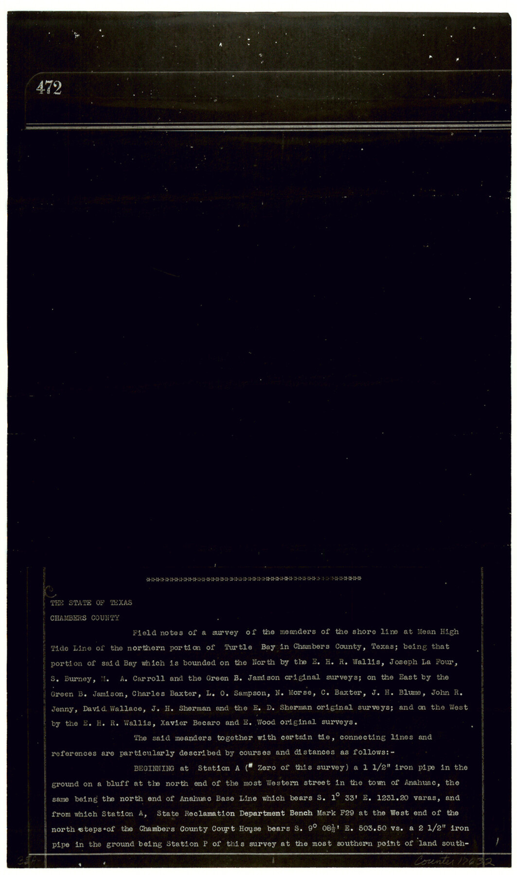
Chambers County Sketch File 35a
[Copy of field notes of the meanders of the shoreline of Turtle Bay and field notes of submerged area tracts in Turtle Bay]
-
Map/Doc
17632
-
Collection
General Map Collection
-
Object Dates
1964/3/12 (File Date)
1935 (Creation Date)
-
People and Organizations
W.O. Work (Surveyor/Engineer)
-
Counties
Chambers
-
Subjects
Surveying Sketch File
-
Height x Width
15.4 x 9.1 inches
39.1 x 23.1 cm
-
Medium
photostat, negative
-
Features
Turtle Bay
Trinity River
Turtle Bayou
Big Hog Bayou
Turtle Pass
Galveston Bay
Part of: General Map Collection
Nueces County Sketch File 25

Print $14.00
- Digital $50.00
Nueces County Sketch File 25
1876
Size 8.7 x 6.3 inches
Map/Doc 32572
Wichita County Working Sketch 12a

Print $20.00
- Digital $50.00
Wichita County Working Sketch 12a
1920
Size 20.2 x 14.1 inches
Map/Doc 72521
Rusk County Rolled Sketch 3

Print $20.00
- Digital $50.00
Rusk County Rolled Sketch 3
Size 21.8 x 38.2 inches
Map/Doc 7542
Flight Mission No. BRE-1P, Frame 45, Nueces County

Print $20.00
- Digital $50.00
Flight Mission No. BRE-1P, Frame 45, Nueces County
1956
Size 16.5 x 16.1 inches
Map/Doc 86634
Kaufman County Boundary File 3

Print $14.00
- Digital $50.00
Kaufman County Boundary File 3
Size 12.7 x 8.2 inches
Map/Doc 55922
Hudspeth County Rolled Sketch 41

Print $40.00
- Digital $50.00
Hudspeth County Rolled Sketch 41
1947
Size 12.6 x 83.1 inches
Map/Doc 76043
Outer Continental Shelf Leasing Maps (Louisiana Offshore Operations)

Print $20.00
- Digital $50.00
Outer Continental Shelf Leasing Maps (Louisiana Offshore Operations)
1959
Size 13.7 x 17.4 inches
Map/Doc 76116
Wichita County Boundary File 2

Print $30.00
- Digital $50.00
Wichita County Boundary File 2
Size 9.1 x 4.7 inches
Map/Doc 59900
Jones County Working Sketch 2

Print $20.00
- Digital $50.00
Jones County Working Sketch 2
1928
Size 19.9 x 22.2 inches
Map/Doc 66640
Intracoastal Waterway - Laguna Madre - Rincon de San Jose to Chubby Island, Texas

Print $20.00
- Digital $50.00
Intracoastal Waterway - Laguna Madre - Rincon de San Jose to Chubby Island, Texas
1975
Size 15.6 x 37.0 inches
Map/Doc 73517
Andrews County Rolled Sketch 41

Print $20.00
- Digital $50.00
Andrews County Rolled Sketch 41
Size 18.0 x 24.0 inches
Map/Doc 77181
Reagan County Working Sketch 5

Print $20.00
- Digital $50.00
Reagan County Working Sketch 5
1924
Size 19.2 x 19.5 inches
Map/Doc 71845
You may also like
Van Zandt County Sketch File 30

Print $4.00
- Digital $50.00
Van Zandt County Sketch File 30
1859
Size 12.2 x 8.0 inches
Map/Doc 39461
Fisher County Sketch File 23

Print $12.00
- Digital $50.00
Fisher County Sketch File 23
1875
Size 10.8 x 8.2 inches
Map/Doc 22660
Val Verde County Sketch File 17

Print $12.00
- Digital $50.00
Val Verde County Sketch File 17
Size 12.9 x 8.1 inches
Map/Doc 39219
[Old Coastal Chart of Texas Coast showing passes with depth readings]
![4662, [Old Coastal Chart of Texas Coast showing passes with depth readings], General Map Collection](https://historictexasmaps.com/wmedia_w700/maps/4662-1.tif.jpg)
Print $40.00
- Digital $50.00
[Old Coastal Chart of Texas Coast showing passes with depth readings]
Size 25.4 x 48.6 inches
Map/Doc 4662
Gonzales County

Print $20.00
- Digital $50.00
Gonzales County
1853
Size 23.4 x 22.4 inches
Map/Doc 3591
La Salle County Sketch File 45

Print $40.00
- Digital $50.00
La Salle County Sketch File 45
1939
Size 16.9 x 14.2 inches
Map/Doc 29601
Bee County Working Sketch 23

Print $20.00
- Digital $50.00
Bee County Working Sketch 23
1985
Size 32.6 x 31.1 inches
Map/Doc 67273
Parker County Boundary File 3a

Print $34.00
- Digital $50.00
Parker County Boundary File 3a
Size 11.2 x 8.8 inches
Map/Doc 57840
Gregg County Boundary File 6a

Print $46.00
- Digital $50.00
Gregg County Boundary File 6a
Size 12.7 x 8.2 inches
Map/Doc 54004
Nueces County Rolled Sketch 34

Print $20.00
- Digital $50.00
Nueces County Rolled Sketch 34
1951
Size 47.9 x 37.5 inches
Map/Doc 9601
Hutchinson County

Print $20.00
- Digital $50.00
Hutchinson County
1922
Size 44.4 x 36.5 inches
Map/Doc 73188
