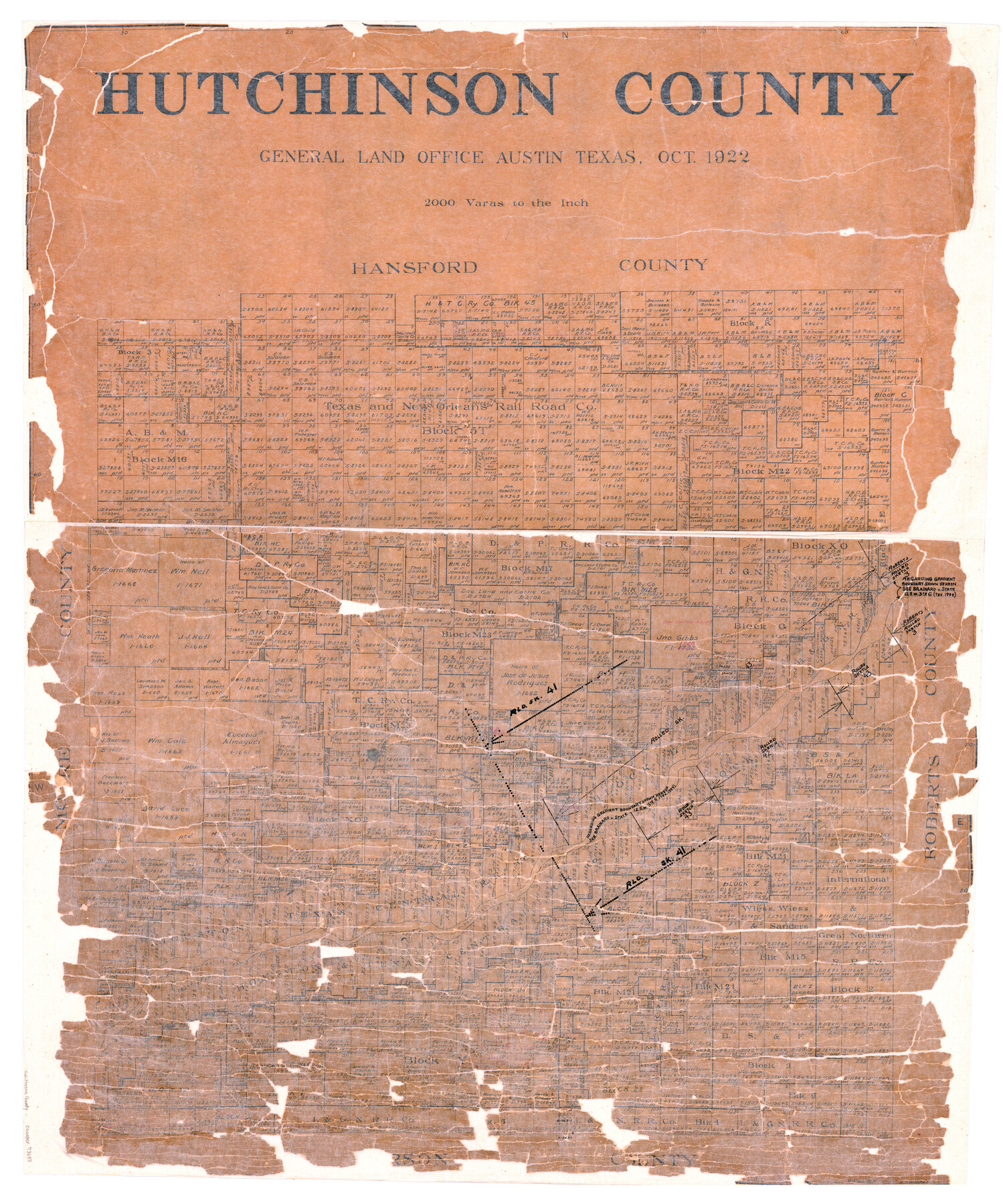
Hutchinson County
-
Map/Doc
73188
-
Collection
General Map Collection
-
Object Dates
1922 (Creation Date)
-
People and Organizations
Texas General Land Office (Publisher)
H.F. McDonald (Draftsman)
-
Counties
Hutchinson
-
Subjects
County
-
Height x Width
44.4 x 36.5 inches
112.8 x 92.7 cm
-
Comments
Hand lettered.
-
Features
White Deer Creek
Stinnett
CRI&G
Canadian River
Plemons
Dixon Creek
Antelope Creek
Part of: General Map Collection
Lynn County Boundary File 10

Print $110.00
- Digital $50.00
Lynn County Boundary File 10
Size 14.3 x 8.7 inches
Map/Doc 56709
Menard County Working Sketch 13

Print $20.00
- Digital $50.00
Menard County Working Sketch 13
1939
Size 27.3 x 38.1 inches
Map/Doc 70960
Brewster County Rolled Sketch 114

Print $20.00
- Digital $50.00
Brewster County Rolled Sketch 114
1964
Size 11.4 x 17.7 inches
Map/Doc 5284
Val Verde County Boundary File 103

Print $82.00
- Digital $50.00
Val Verde County Boundary File 103
Size 9.1 x 9.1 inches
Map/Doc 59577
Kimble County Sketch File 9a

Print $4.00
- Digital $50.00
Kimble County Sketch File 9a
Size 12.4 x 9.2 inches
Map/Doc 28929
Flight Mission No. DQO-3K, Frame 37, Galveston County

Print $20.00
- Digital $50.00
Flight Mission No. DQO-3K, Frame 37, Galveston County
1952
Size 18.7 x 22.6 inches
Map/Doc 85078
Wilbarger County Working Sketch 20

Print $20.00
- Digital $50.00
Wilbarger County Working Sketch 20
1976
Size 27.4 x 43.4 inches
Map/Doc 72558
Edwards County Rolled Sketch 29

Print $40.00
- Digital $50.00
Edwards County Rolled Sketch 29
1974
Size 49.1 x 29.1 inches
Map/Doc 8847
Wharton County Working Sketch 21

Print $20.00
- Digital $50.00
Wharton County Working Sketch 21
1937
Size 16.9 x 20.8 inches
Map/Doc 72485
Zapata County Rolled Sketch 7A

Print $20.00
- Digital $50.00
Zapata County Rolled Sketch 7A
1912
Size 17.9 x 26.6 inches
Map/Doc 8309
Aransas County Sketch File 21d

Print $4.00
- Digital $50.00
Aransas County Sketch File 21d
Size 14.4 x 8.9 inches
Map/Doc 13164
Chambers County Sketch File 5

Print $2.00
- Digital $50.00
Chambers County Sketch File 5
Size 7.2 x 6.3 inches
Map/Doc 17539
You may also like
Clason's Guide Map of Texas

Print $20.00
- Digital $50.00
Clason's Guide Map of Texas
1919
Size 22.4 x 24.5 inches
Map/Doc 97157
Victoria County Sketch File 14

Print $10.00
- Digital $50.00
Victoria County Sketch File 14
2002
Size 11.0 x 8.5 inches
Map/Doc 95398
[Sketch for Mineral Application 16787 - Pecos River Bed, A. T. Freet]
![2815, [Sketch for Mineral Application 16787 - Pecos River Bed, A. T. Freet], General Map Collection](https://historictexasmaps.com/wmedia_w700/maps/2815-1.tif.jpg)
Print $20.00
- Digital $50.00
[Sketch for Mineral Application 16787 - Pecos River Bed, A. T. Freet]
1927
Size 20.0 x 46.7 inches
Map/Doc 2815
Harrison County Sketch File 12

Print $20.00
- Digital $50.00
Harrison County Sketch File 12
Size 21.5 x 24.1 inches
Map/Doc 11687
Sectional Map No. 2 of the lands and the line of the Texas & Pacific Ry. Co. in Howard, Martin, Andrews, Midland and Tom Green Counties

Print $20.00
- Digital $50.00
Sectional Map No. 2 of the lands and the line of the Texas & Pacific Ry. Co. in Howard, Martin, Andrews, Midland and Tom Green Counties
1885
Size 18.9 x 23.4 inches
Map/Doc 4859
Kerr County Working Sketch 17

Print $20.00
- Digital $50.00
Kerr County Working Sketch 17
1956
Size 20.0 x 23.7 inches
Map/Doc 70048
Maps of Gulf Intracoastal Waterway, Texas - Sabine River to the Rio Grande and connecting waterways including ship channels

Print $20.00
- Digital $50.00
Maps of Gulf Intracoastal Waterway, Texas - Sabine River to the Rio Grande and connecting waterways including ship channels
1966
Size 14.6 x 22.3 inches
Map/Doc 61962
[Sketch for Mineral Application 27669 - Trinity River, Frank R. Graves]
![2859, [Sketch for Mineral Application 27669 - Trinity River, Frank R. Graves], General Map Collection](https://historictexasmaps.com/wmedia_w700/maps/2859-1.tif.jpg)
Print $40.00
- Digital $50.00
[Sketch for Mineral Application 27669 - Trinity River, Frank R. Graves]
1934
Size 27.9 x 51.7 inches
Map/Doc 2859
Victoria County Sketch File V1

Print $10.00
- Digital $50.00
Victoria County Sketch File V1
1896
Size 14.6 x 9.2 inches
Map/Doc 39525
La Salle County Boundary File 2

Print $2.00
- Digital $50.00
La Salle County Boundary File 2
Size 11.1 x 8.6 inches
Map/Doc 56241
Montgomery County Sketch File 15

Print $4.00
- Digital $50.00
Montgomery County Sketch File 15
1906
Size 9.4 x 8.5 inches
Map/Doc 31817
Palo Pinto County Sketch File 8

Print $40.00
- Digital $50.00
Palo Pinto County Sketch File 8
Size 15.3 x 15.6 inches
Map/Doc 33400