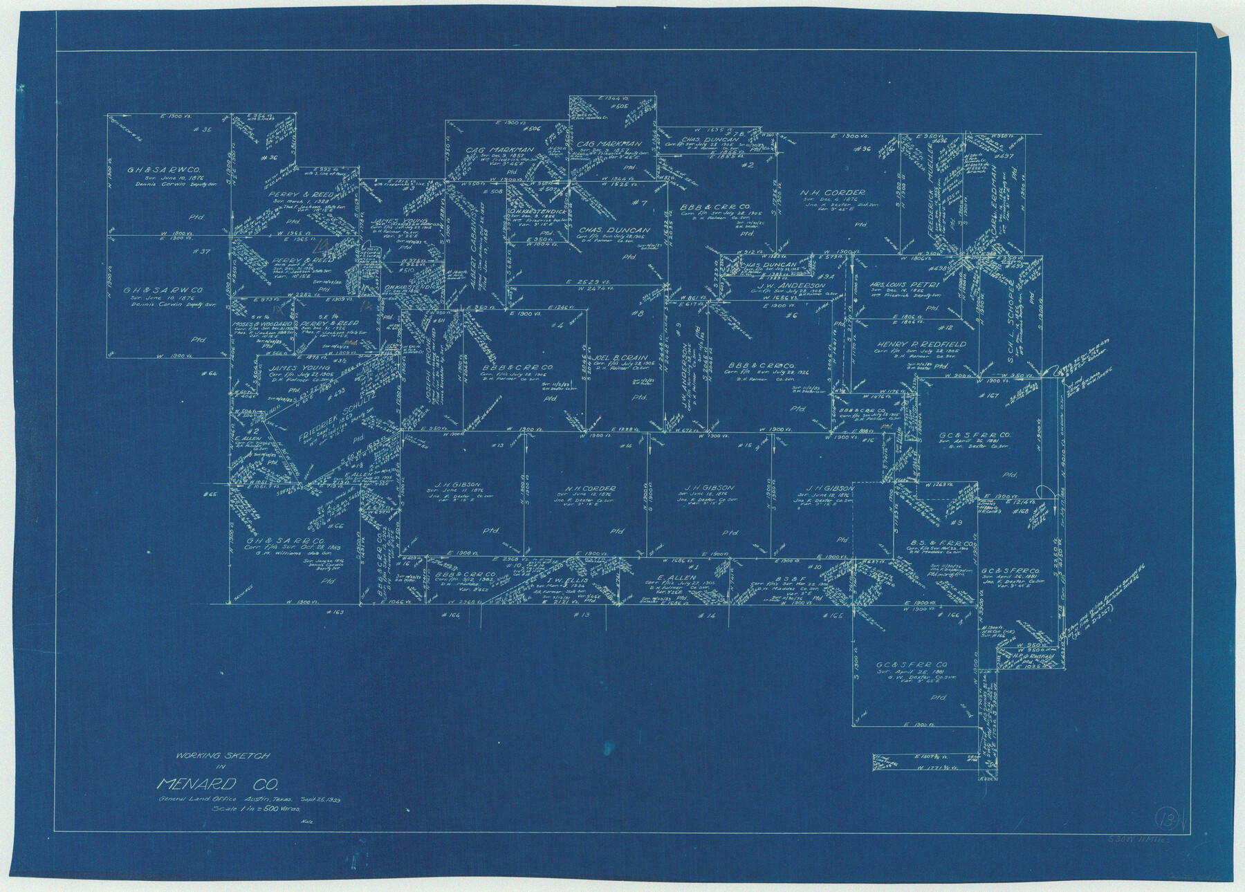
Menard County Working Sketch 13
-
Map/Doc
70960
-
Collection
General Map Collection
-
Object Dates
9/25/1939 (Creation Date)
-
Counties
Menard
-
Subjects
Surveying Working Sketch
-
Height x Width
27.3 x 38.1 inches
69.3 x 96.8 cm
-
Scale
1" = 500 varas
Part of: General Map Collection
Crockett County Sketch File 71

Print $8.00
- Digital $50.00
Crockett County Sketch File 71
1934
Size 11.2 x 8.8 inches
Map/Doc 19858
Duval County Boundary File 3

Print $14.00
- Digital $50.00
Duval County Boundary File 3
Size 8.6 x 3.9 inches
Map/Doc 52719
Hutchinson County Sketch File 53

Print $2.00
- Digital $50.00
Hutchinson County Sketch File 53
2000
Size 11.2 x 8.8 inches
Map/Doc 27455
San Jacinto County Working Sketch 10

Print $20.00
- Digital $50.00
San Jacinto County Working Sketch 10
1935
Size 40.1 x 40.1 inches
Map/Doc 63723
Gregg County Working Sketch 24

Print $20.00
- Digital $50.00
Gregg County Working Sketch 24
1985
Size 26.6 x 16.3 inches
Map/Doc 63291
Morris County Rolled Sketch 2A

Print $20.00
- Digital $50.00
Morris County Rolled Sketch 2A
Size 24.0 x 18.8 inches
Map/Doc 10274
Map of Chicago, Rock Island & Texas Railroad

Print $40.00
- Digital $50.00
Map of Chicago, Rock Island & Texas Railroad
1892
Size 23.9 x 122.0 inches
Map/Doc 64442
Clay County Sketch File 36

Print $3.00
- Digital $50.00
Clay County Sketch File 36
Size 17.0 x 11.0 inches
Map/Doc 18464
Flight Mission No. DIX-7P, Frame 91, Aransas County

Print $20.00
- Digital $50.00
Flight Mission No. DIX-7P, Frame 91, Aransas County
1956
Size 18.7 x 22.4 inches
Map/Doc 83885
Brewster County Sketch File N-17

Print $80.00
- Digital $50.00
Brewster County Sketch File N-17
1939
Size 8.9 x 14.4 inches
Map/Doc 15651
Galveston County NRC Article 33.136 Location Key Sheet

Print $20.00
- Digital $50.00
Galveston County NRC Article 33.136 Location Key Sheet
1995
Size 27.0 x 22.0 inches
Map/Doc 83001

You may also like
[Map of the Houston and G. N. R.R. and lands adjacent, from Troupe to the Texas Pacific R.R.]
![64628, [Map of the Houston and G. N. R.R. and lands adjacent, from Troupe to the Texas Pacific R.R.], General Map Collection](https://historictexasmaps.com/wmedia_w700/maps/64628.tif.jpg)
Print $40.00
- Digital $50.00
[Map of the Houston and G. N. R.R. and lands adjacent, from Troupe to the Texas Pacific R.R.]
1873
Size 20.2 x 49.3 inches
Map/Doc 64628
Starr County Rolled Sketch 39

Print $20.00
- Digital $50.00
Starr County Rolled Sketch 39
1954
Size 24.9 x 27.7 inches
Map/Doc 7833
Lane Estate Ranch, Gaines County, Texas

Print $20.00
- Digital $50.00
Lane Estate Ranch, Gaines County, Texas
1954
Size 9.1 x 20.8 inches
Map/Doc 92677
Borden County Working Sketch 14

Print $20.00
- Digital $50.00
Borden County Working Sketch 14
1959
Size 27.8 x 25.2 inches
Map/Doc 67474
Robertson County Working Sketch 14

Print $40.00
- Digital $50.00
Robertson County Working Sketch 14
1988
Size 50.0 x 40.8 inches
Map/Doc 78227
Throckmorton County

Print $20.00
- Digital $50.00
Throckmorton County
1880
Size 24.5 x 19.3 inches
Map/Doc 4079
Dickens County Sketch File 29

Print $6.00
- Digital $50.00
Dickens County Sketch File 29
1921
Size 5.9 x 8.8 inches
Map/Doc 21016
Henderson County Working Sketch 37

Print $20.00
- Digital $50.00
Henderson County Working Sketch 37
1982
Size 29.4 x 22.0 inches
Map/Doc 66170
Kleberg County Rolled Sketch 10-16

Print $20.00
- Digital $50.00
Kleberg County Rolled Sketch 10-16
1952
Size 37.0 x 33.2 inches
Map/Doc 9381
Val Verde County Working Sketch 65

Print $20.00
- Digital $50.00
Val Verde County Working Sketch 65
1960
Size 30.9 x 31.8 inches
Map/Doc 72200
No. 3 Chart of Channel connecting Corpus Christi Bay with Aransas Bay, Texas

Print $20.00
- Digital $50.00
No. 3 Chart of Channel connecting Corpus Christi Bay with Aransas Bay, Texas
1878
Size 18.1 x 27.9 inches
Map/Doc 72776
Val Verde County Working Sketch 6

Print $20.00
- Digital $50.00
Val Verde County Working Sketch 6
1915
Size 23.2 x 20.7 inches
Map/Doc 72141