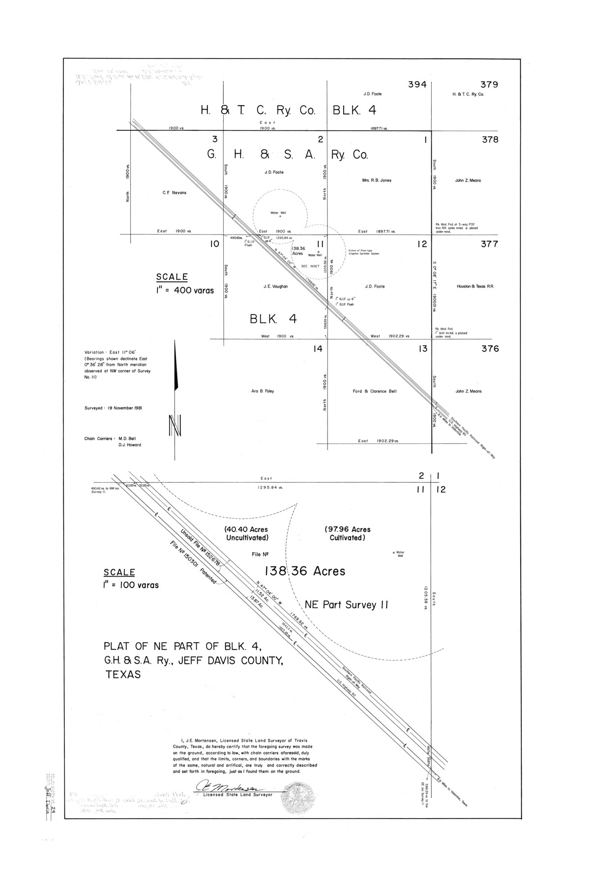
Jeff Davis County Rolled Sketch 29
Plat of NE part of Blk. 4, G. H. & S. A. Ry., Jeff Davis County, Texas
-
Map/Doc
6377
-
Collection
General Map Collection
-
Object Dates
11/19/1981 (Survey Date)
11/30/1981 (File Date)
-
People and Organizations
James E. Mortensen (Surveyor/Engineer)
M. D. Bell (Chainman/Field Personnel)
Douglas Howard (Chainman/Field Personnel)
-
Counties
Jeff Davis
-
Subjects
Surveying Rolled Sketch
-
Height x Width
40.4 x 27.2 inches
102.6 x 69.1 cm
-
Scale
1" = 400 varas
Part of: General Map Collection
Floyd County Boundary File 2a

Print $40.00
- Digital $50.00
Floyd County Boundary File 2a
Size 19.8 x 39.2 inches
Map/Doc 53488
San Augustine County Sketch File 13

Print $4.00
San Augustine County Sketch File 13
1875
Size 11.4 x 7.6 inches
Map/Doc 35658
Presidio County Sketch File 72

Print $6.00
- Digital $50.00
Presidio County Sketch File 72
1943
Size 13.3 x 8.8 inches
Map/Doc 34679
Callahan County Working Sketch 7

Print $20.00
- Digital $50.00
Callahan County Working Sketch 7
1955
Size 25.1 x 12.7 inches
Map/Doc 67889
Loving County Working Sketch 22

Print $20.00
- Digital $50.00
Loving County Working Sketch 22
1984
Size 18.3 x 34.9 inches
Map/Doc 70656
Pecos County Rolled Sketch 142

Print $20.00
- Digital $50.00
Pecos County Rolled Sketch 142
Size 26.9 x 41.9 inches
Map/Doc 7276
Parker County Sketch File 13

Print $4.00
- Digital $50.00
Parker County Sketch File 13
1860
Size 12.1 x 8.0 inches
Map/Doc 33546
Flight Mission No. CRC-4R, Frame 180, Chambers County

Print $20.00
- Digital $50.00
Flight Mission No. CRC-4R, Frame 180, Chambers County
1956
Size 18.6 x 22.2 inches
Map/Doc 84931
Intracoastal Waterway in Texas - Corpus Christi to Point Isabel including Arroyo Colorado to Mo. Pac. R.R. Bridge Near Harlingen

Print $20.00
- Digital $50.00
Intracoastal Waterway in Texas - Corpus Christi to Point Isabel including Arroyo Colorado to Mo. Pac. R.R. Bridge Near Harlingen
1933
Size 28.0 x 41.0 inches
Map/Doc 61875
Map of San Patricio County

Print $40.00
- Digital $50.00
Map of San Patricio County
1896
Size 31.6 x 51.2 inches
Map/Doc 63018
Hall County Sketch File 15

Print $6.00
- Digital $50.00
Hall County Sketch File 15
Size 5.7 x 16.9 inches
Map/Doc 24814
Hale County Sketch File 18

Print $4.00
- Digital $50.00
Hale County Sketch File 18
1903
Size 11.0 x 8.6 inches
Map/Doc 24749
You may also like
Crockett County Sketch File 4

Print $6.00
- Digital $50.00
Crockett County Sketch File 4
Size 6.4 x 5.2 inches
Map/Doc 19649

Borden County Sketch File 1

Print $6.00
- Digital $50.00
Borden County Sketch File 1
Size 16.2 x 11.0 inches
Map/Doc 14701

Medina County Working Sketch 24

Print $20.00
- Digital $50.00
Medina County Working Sketch 24
1984
Size 26.1 x 36.7 inches
Map/Doc 70939
Falls County Sketch File 32

Print $20.00
- Digital $50.00
Falls County Sketch File 32
Size 36.3 x 24.7 inches
Map/Doc 11468
San Augustine County Working Sketch 20

Print $20.00
- Digital $50.00
San Augustine County Working Sketch 20
1969
Size 15.1 x 24.0 inches
Map/Doc 63708
Scurry County Rolled Sketch 4

Print $20.00
- Digital $50.00
Scurry County Rolled Sketch 4
Size 35.7 x 26.0 inches
Map/Doc 7765
[Blocks 1 and H]
![90719, [Blocks 1 and H], Twichell Survey Records](https://historictexasmaps.com/wmedia_w700/maps/90719-1.tif.jpg)
Print $20.00
- Digital $50.00
[Blocks 1 and H]
Size 27.1 x 21.6 inches
Map/Doc 90719
Crockett County Rolled Sketch 88K

Print $40.00
- Digital $50.00
Crockett County Rolled Sketch 88K
1973
Size 43.0 x 57.4 inches
Map/Doc 8735
General Highway Map. Detail of Cities and Towns in Tarrant County, Texas. City Map, Fort Worth and vicinity, Tarrant County, Texas

Print $20.00
General Highway Map. Detail of Cities and Towns in Tarrant County, Texas. City Map, Fort Worth and vicinity, Tarrant County, Texas
1961
Size 18.2 x 24.9 inches
Map/Doc 79667
Wichita County Sketch File 8

Print $4.00
- Digital $50.00
Wichita County Sketch File 8
1860
Size 11.7 x 8.2 inches
Map/Doc 40048