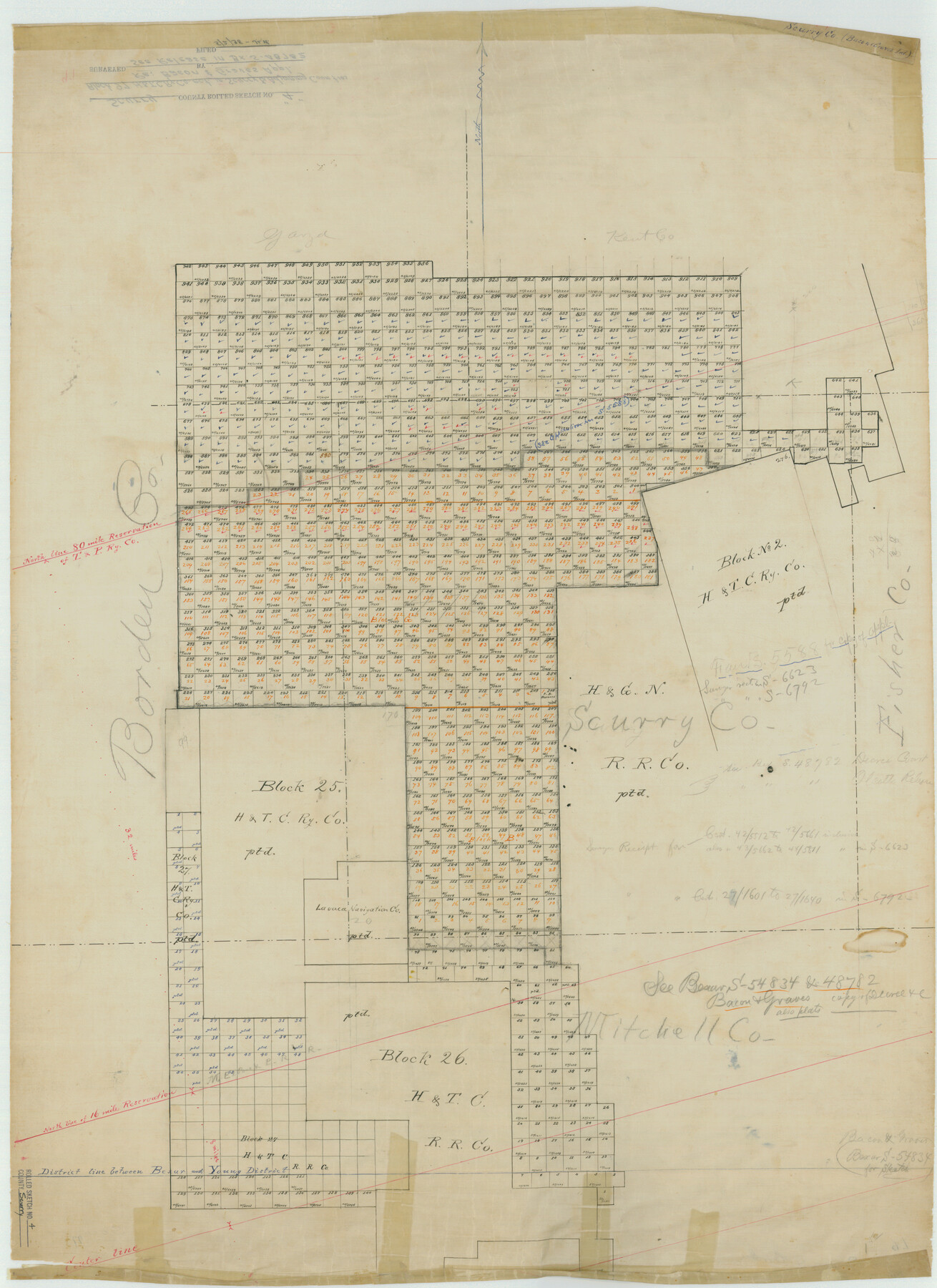
Scurry County Rolled Sketch 4
[Block 97, H. & T. C. R.R. Co. in Scurry and surrounding counties]
-
Map/Doc
7765
-
Collection
General Map Collection
-
Counties
Scurry Borden Kent Garza Mitchell
-
Subjects
Cadastral Surveying Rolled Sketch
-
Height x Width
35.7 x 26.0 inches
90.7 x 66.0 cm
-
Medium
linen, manuscript
Part of: General Map Collection
Pecos County Working Sketch Graphic index - northwest part - sheet A
![76663, Pecos County Working Sketch Graphic index - northwest part - sheet A, General Map Collection](https://historictexasmaps.com/wmedia_w700/maps/76663.tif.jpg)
Print $20.00
- Digital $50.00
Pecos County Working Sketch Graphic index - northwest part - sheet A
1975
Size 42.2 x 42.6 inches
Map/Doc 76663
Northwest Part Crockett County
![95470, Northwest Part Crockett County, General Map Collection](https://historictexasmaps.com/wmedia_w700/maps/95470.tif.jpg)
Print $40.00
- Digital $50.00
Northwest Part Crockett County
1983
Size 37.3 x 48.3 inches
Map/Doc 95470
Right of Way and Track Map, the Missouri, Kansas and Texas Ry. of Texas operated by the Missouri, Kansas and Texas Ry. of Texas, San Antonio Division
![64579, Right of Way and Track Map, the Missouri, Kansas and Texas Ry. of Texas operated by the Missouri, Kansas and Texas Ry. of Texas, San Antonio Division, General Map Collection](https://historictexasmaps.com/wmedia_w700/maps/64579.tif.jpg)
Print $40.00
- Digital $50.00
Right of Way and Track Map, the Missouri, Kansas and Texas Ry. of Texas operated by the Missouri, Kansas and Texas Ry. of Texas, San Antonio Division
1918
Size 25.3 x 58.3 inches
Map/Doc 64579
Flight Mission No. DQO-8K, Frame 90, Galveston County
![85192, Flight Mission No. DQO-8K, Frame 90, Galveston County, General Map Collection](https://historictexasmaps.com/wmedia_w700/pdf_converted_jpg/qi_pdf_thumbnail_32400.jpg)
Print $20.00
- Digital $50.00
Flight Mission No. DQO-8K, Frame 90, Galveston County
1952
Size 17.9 x 22.3 inches
Map/Doc 85192
Clay County Working Sketch 6
![68029, Clay County Working Sketch 6, General Map Collection](https://historictexasmaps.com/wmedia_w700/maps/68029.tif.jpg)
Print $20.00
- Digital $50.00
Clay County Working Sketch 6
Size 30.0 x 24.1 inches
Map/Doc 68029
[F. W. & D. C. Ry. Co. Alignment and Right of Way Map, Clay County]
![64739, [F. W. & D. C. Ry. Co. Alignment and Right of Way Map, Clay County], General Map Collection](https://historictexasmaps.com/wmedia_w700/maps/64739-GC.tif.jpg)
Print $20.00
- Digital $50.00
[F. W. & D. C. Ry. Co. Alignment and Right of Way Map, Clay County]
1927
Size 18.6 x 11.7 inches
Map/Doc 64739
Sketch I: Showing the Progress of the Survey in Section No. 9 [Galveston Bay]
![97133, Sketch I: Showing the Progress of the Survey in Section No. 9 [Galveston Bay], General Map Collection](https://historictexasmaps.com/wmedia_w700/maps/97133.tif.jpg)
Print $20.00
- Digital $50.00
Sketch I: Showing the Progress of the Survey in Section No. 9 [Galveston Bay]
1852
Size 9.4 x 13.4 inches
Map/Doc 97133
Flight Mission No. DQO-2K, Frame 87, Galveston County
![85014, Flight Mission No. DQO-2K, Frame 87, Galveston County, General Map Collection](https://historictexasmaps.com/wmedia_w700/pdf_converted_jpg/qi_pdf_thumbnail_32226.jpg)
Print $20.00
- Digital $50.00
Flight Mission No. DQO-2K, Frame 87, Galveston County
1952
Size 18.7 x 22.5 inches
Map/Doc 85014
Orange County Rolled Sketch RG
![9654, Orange County Rolled Sketch RG, General Map Collection](https://historictexasmaps.com/wmedia_w700/maps/9654.tif.jpg)
Print $40.00
- Digital $50.00
Orange County Rolled Sketch RG
1919
Size 61.2 x 32.7 inches
Map/Doc 9654
Panola County Sketch File 8
![33459, Panola County Sketch File 8, General Map Collection](https://historictexasmaps.com/wmedia_w700/pdf_converted_jpg/qi_pdf_thumbnail_13477.jpg)
Print $4.00
- Digital $50.00
Panola County Sketch File 8
1862
Size 12.8 x 7.8 inches
Map/Doc 33459
Bexar County Sketch File 11
![14481, Bexar County Sketch File 11, General Map Collection](https://historictexasmaps.com/wmedia_w700/pdf_converted_jpg/qi_pdf_thumbnail_9397.jpg)
Print $2.00
- Digital $50.00
Bexar County Sketch File 11
Size 8.3 x 9.5 inches
Map/Doc 14481
West Part of Liberty Co.
![77353, West Part of Liberty Co., General Map Collection](https://historictexasmaps.com/wmedia_w700/maps/77353.tif.jpg)
Print $20.00
- Digital $50.00
West Part of Liberty Co.
1977
Size 43.5 x 32.9 inches
Map/Doc 77353
You may also like
Dallas County Sketch File 14
![20428, Dallas County Sketch File 14, General Map Collection](https://historictexasmaps.com/wmedia_w700/pdf_converted_jpg/qi_pdf_thumbnail_10615.jpg)
Print $22.00
- Digital $50.00
Dallas County Sketch File 14
1859
Size 8.2 x 7.6 inches
Map/Doc 20428
Panola County Working Sketch 34
![71443, Panola County Working Sketch 34, General Map Collection](https://historictexasmaps.com/wmedia_w700/maps/71443.tif.jpg)
Print $20.00
- Digital $50.00
Panola County Working Sketch 34
Size 26.4 x 38.7 inches
Map/Doc 71443
Pecos County Sketch [University Blocks 19 and 20]
![2439, Pecos County Sketch [University Blocks 19 and 20], General Map Collection](https://historictexasmaps.com/wmedia_w700/maps/2439.tif.jpg)
Print $20.00
- Digital $50.00
Pecos County Sketch [University Blocks 19 and 20]
1951
Size 31.3 x 15.8 inches
Map/Doc 2439
Terrell County Sketch File 2-3
![](https://historictexasmaps.com/wmedia_w700/pdf_converted_jpg/qi_pdf_thumbnail_70612.jpg)
Print $38.00
- Digital $50.00
Terrell County Sketch File 2-3
1882
Size 9.1 x 7.7 inches
Map/Doc 37879
Map of Wilbarger County Young Land District formerly Fannin Land District
![4146, Map of Wilbarger County Young Land District formerly Fannin Land District, General Map Collection](https://historictexasmaps.com/wmedia_w700/maps/4146-1.tif.jpg)
Print $20.00
- Digital $50.00
Map of Wilbarger County Young Land District formerly Fannin Land District
1859
Size 22.7 x 20.6 inches
Map/Doc 4146
El Paso County Rolled Sketch 43A
![5829, El Paso County Rolled Sketch 43A, General Map Collection](https://historictexasmaps.com/wmedia_w700/maps/5829.tif.jpg)
Print $20.00
- Digital $50.00
El Paso County Rolled Sketch 43A
Size 23.2 x 22.6 inches
Map/Doc 5829
Atascosa County
![3248, Atascosa County, General Map Collection](https://historictexasmaps.com/wmedia_w700/maps/3248.tif.jpg)
Print $20.00
- Digital $50.00
Atascosa County
1862
Size 29.8 x 25.2 inches
Map/Doc 3248
Description of Best Route from Austin to San Antonio, Texas
![79296, Description of Best Route from Austin to San Antonio, Texas, Texas State Library and Archives](https://historictexasmaps.com/wmedia_w700/maps/79296.tif.jpg)
Print $20.00
Description of Best Route from Austin to San Antonio, Texas
1865
Size 12.9 x 13.1 inches
Map/Doc 79296
Gonzales County Working Sketch 5
![63221, Gonzales County Working Sketch 5, General Map Collection](https://historictexasmaps.com/wmedia_w700/maps/63221.tif.jpg)
Print $20.00
- Digital $50.00
Gonzales County Working Sketch 5
Size 31.2 x 43.6 inches
Map/Doc 63221
Flight Mission No. CLL-1N, Frame 19, Willacy County
![87006, Flight Mission No. CLL-1N, Frame 19, Willacy County, General Map Collection](https://historictexasmaps.com/wmedia_w700/pdf_converted_jpg/qi_pdf_thumbnail_34140.jpg)
Print $20.00
- Digital $50.00
Flight Mission No. CLL-1N, Frame 19, Willacy County
1954
Size 18.3 x 22.1 inches
Map/Doc 87006
Souvenir of Galveston the Sea Wall City
![](https://historictexasmaps.com/wmedia_w700/pdf_converted_jpg/qi_pdf_thumbnail_66963.jpg)
Souvenir of Galveston the Sea Wall City
Size 5.7 x 7.6 inches
Map/Doc 97051
Webb County Sketch File 13a
![12631, Webb County Sketch File 13a, General Map Collection](https://historictexasmaps.com/wmedia_w700/pdf_converted_jpg/qi_pdf_thumbnail_8901.jpg)
Print $20.00
- Digital $50.00
Webb County Sketch File 13a
1881
Size 19.0 x 25.7 inches
Map/Doc 12631