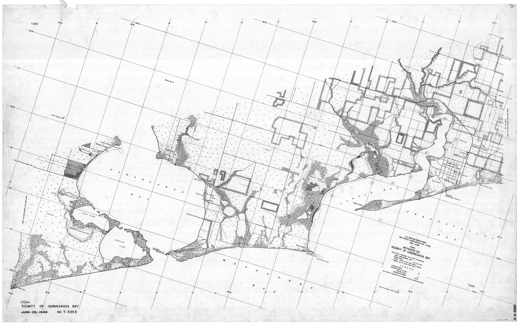
Texas, Matagorda Bay, Vicinity of Carancahua Bay
K-2-5355
-
Map/Doc
69989
-
Collection
General Map Collection
-
Object Dates
1933/12/19 (Creation Date)
-
Counties
Matagorda Calhoun
-
Subjects
Nautical Charts
-
Height x Width
30.3 x 48.2 inches
77.0 x 122.4 cm
Part of: General Map Collection
Pecos County Rolled Sketch 156

Print $40.00
- Digital $50.00
Pecos County Rolled Sketch 156
1938
Size 39.7 x 48.1 inches
Map/Doc 9738
Coke County Rolled Sketch 7

Print $20.00
- Digital $50.00
Coke County Rolled Sketch 7
Size 19.0 x 24.1 inches
Map/Doc 5506
Webb County Working Sketch 18

Print $20.00
- Digital $50.00
Webb County Working Sketch 18
1923
Size 18.6 x 12.8 inches
Map/Doc 72383
[Surveys in the Bexar District along the Balcones, Cibolo and Leon Creeks]
![63, [Surveys in the Bexar District along the Balcones, Cibolo and Leon Creeks], General Map Collection](https://historictexasmaps.com/wmedia_w700/maps/63.tif.jpg)
Print $3.00
- Digital $50.00
[Surveys in the Bexar District along the Balcones, Cibolo and Leon Creeks]
1842
Size 10.6 x 12.4 inches
Map/Doc 63
Pecos County Sketch File 66

Print $40.00
- Digital $50.00
Pecos County Sketch File 66
Size 14.3 x 16.2 inches
Map/Doc 33826
[Galveston, Harrisburg & San Antonio Railroad from Cuero to Stockdale]
![64195, [Galveston, Harrisburg & San Antonio Railroad from Cuero to Stockdale], General Map Collection](https://historictexasmaps.com/wmedia_w700/maps/64195.tif.jpg)
Print $20.00
- Digital $50.00
[Galveston, Harrisburg & San Antonio Railroad from Cuero to Stockdale]
1907
Size 14.0 x 34.1 inches
Map/Doc 64195
Township No. 1 South Range No. 24 West of the Indian Meridian

Print $20.00
- Digital $50.00
Township No. 1 South Range No. 24 West of the Indian Meridian
1875
Size 19.2 x 24.4 inches
Map/Doc 75173
United States Atlantic and Gulf Coasts Including Puerto Rico and the Virgin Islands

Print $40.00
- Digital $50.00
United States Atlantic and Gulf Coasts Including Puerto Rico and the Virgin Islands
1989
Size 21.4 x 60.4 inches
Map/Doc 73552
Freestone County Sketch File 24

Print $20.00
- Digital $50.00
Freestone County Sketch File 24
1951
Size 23.1 x 17.9 inches
Map/Doc 11517
Flight Mission No. BQR-7K, Frame 26, Brazoria County

Print $20.00
- Digital $50.00
Flight Mission No. BQR-7K, Frame 26, Brazoria County
1952
Size 18.7 x 22.3 inches
Map/Doc 84024
Fort Bend County Working Sketch 24

Print $20.00
- Digital $50.00
Fort Bend County Working Sketch 24
1981
Size 27.1 x 30.5 inches
Map/Doc 69230
[Blanco County]
![3307, [Blanco County], General Map Collection](https://historictexasmaps.com/wmedia_w700/maps/3307-2.tif.jpg)
Print $20.00
- Digital $50.00
[Blanco County]
1872
Size 19.1 x 16.0 inches
Map/Doc 3307
You may also like
McCulloch County Working Sketch 9

Print $20.00
- Digital $50.00
McCulloch County Working Sketch 9
1978
Size 35.6 x 32.7 inches
Map/Doc 70684
Brewster County Rolled Sketch 60

Print $20.00
- Digital $50.00
Brewster County Rolled Sketch 60
Size 24.8 x 36.5 inches
Map/Doc 61783
Ector County Sketch File 13

Print $16.00
- Digital $50.00
Ector County Sketch File 13
1988
Size 11.5 x 9.0 inches
Map/Doc 21651
Brewster County Sketch File S-26a

Print $18.00
- Digital $50.00
Brewster County Sketch File S-26a
1964
Size 11.1 x 8.7 inches
Map/Doc 15837
Flight Mission No. DQO-8K, Frame 17, Galveston County

Print $20.00
- Digital $50.00
Flight Mission No. DQO-8K, Frame 17, Galveston County
1952
Size 18.6 x 22.4 inches
Map/Doc 85140
[Sketch of Leagues 458, 459, 474, 475, 480 and 481]
![91547, [Sketch of Leagues 458, 459, 474, 475, 480 and 481], Twichell Survey Records](https://historictexasmaps.com/wmedia_w700/maps/91547-1.tif.jpg)
Print $2.00
- Digital $50.00
[Sketch of Leagues 458, 459, 474, 475, 480 and 481]
Size 5.2 x 8.3 inches
Map/Doc 91547
[Surveys in Austin's Colony along the Brazos River]
![214, [Surveys in Austin's Colony along the Brazos River], General Map Collection](https://historictexasmaps.com/wmedia_w700/maps/214.tif.jpg)
Print $2.00
- Digital $50.00
[Surveys in Austin's Colony along the Brazos River]
Size 9.0 x 8.7 inches
Map/Doc 214

Young County Rolled Sketch 18

Print $20.00
- Digital $50.00
Young County Rolled Sketch 18
2020
Size 22.6 x 30.4 inches
Map/Doc 95960
Frio County Rolled Sketch 26

Print $20.00
- Digital $50.00
Frio County Rolled Sketch 26
1994
Size 28.1 x 38.9 inches
Map/Doc 5926
Midland County Working Sketch 1

Print $20.00
- Digital $50.00
Midland County Working Sketch 1
Size 26.8 x 8.7 inches
Map/Doc 70981
Tom Green County

Print $40.00
- Digital $50.00
Tom Green County
1942
Size 55.7 x 46.7 inches
Map/Doc 95655