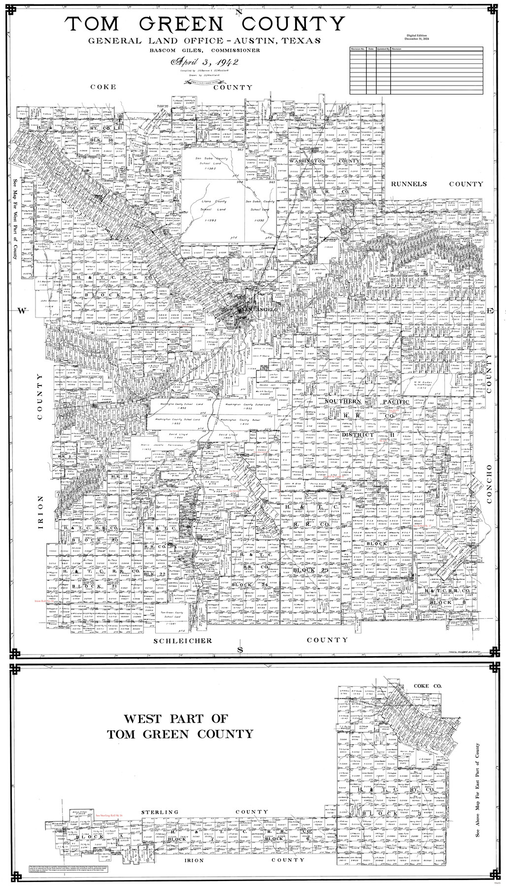
Tom Green County
General Land Office Official County Map
-
Map/Doc
95655
-
Collection
General Map Collection
-
Object Dates
4/3/1942 (Creation Date)
12/31/2024 (Revision Date)
-
People and Organizations
J.L. Woodland (Draftsman)
J.O. Barrow (Compiler)
J.L. Woodland (Compiler)
Bascom Giles (GLO Commissioner)
-
Counties
Tom Green
-
Subjects
County OCM
-
Height x Width
55.7 x 46.7 inches
141.5 x 118.6 cm
-
Medium
digital image
-
Scale
1" = 2000 varas
Part of: General Map Collection
Jones County Sketch File 8

Print $20.00
- Digital $50.00
Jones County Sketch File 8
Size 18.5 x 22.8 inches
Map/Doc 11898
Flight Mission No. CUG-2P, Frame 82, Kleberg County

Print $20.00
- Digital $50.00
Flight Mission No. CUG-2P, Frame 82, Kleberg County
1956
Size 18.5 x 22.3 inches
Map/Doc 86214
Caldwell County

Print $20.00
- Digital $50.00
Caldwell County
1935
Size 39.6 x 43.7 inches
Map/Doc 1791
Runnels County Working Sketch 12

Print $20.00
- Digital $50.00
Runnels County Working Sketch 12
1950
Size 27.7 x 33.0 inches
Map/Doc 63608
Trinity River, Red Bank Sheet

Print $20.00
- Digital $50.00
Trinity River, Red Bank Sheet
1925
Size 16.4 x 24.4 inches
Map/Doc 69687
Presidio County Working Sketch 15

Print $20.00
- Digital $50.00
Presidio County Working Sketch 15
1942
Size 38.1 x 41.3 inches
Map/Doc 71691

Hunt County Boundary File 9

Print $64.00
- Digital $50.00
Hunt County Boundary File 9
Size 8.9 x 8.9 inches
Map/Doc 55241
Lee County Working Sketch 1

Print $20.00
- Digital $50.00
Lee County Working Sketch 1
1940
Size 26.7 x 26.8 inches
Map/Doc 70380
Nacogdoches County Boundary File 1

Print $36.00
- Digital $50.00
Nacogdoches County Boundary File 1
Size 6.7 x 4.4 inches
Map/Doc 57562
Tom Green County Rolled Sketch 23

Print $20.00
- Digital $50.00
Tom Green County Rolled Sketch 23
Size 19.1 x 21.9 inches
Map/Doc 8005
Waller County Sketch File 6

Print $12.00
- Digital $50.00
Waller County Sketch File 6
Size 13.1 x 6.3 inches
Map/Doc 39602
You may also like
[Sketch showing I. & G. N. Block 1 along river, Runnels County School Land and Ira G. Yates]
![91595, [Sketch showing I. & G. N. Block 1 along river, Runnels County School Land and Ira G. Yates], Twichell Survey Records](https://historictexasmaps.com/wmedia_w700/maps/91595-1.tif.jpg)
Print $20.00
- Digital $50.00
[Sketch showing I. & G. N. Block 1 along river, Runnels County School Land and Ira G. Yates]
Size 17.2 x 23.3 inches
Map/Doc 91595

Marion County Sketch File 3

Print $8.00
- Digital $50.00
Marion County Sketch File 3
1860
Size 14.1 x 8.8 inches
Map/Doc 30566
Travis County Working Sketch 6

Print $20.00
- Digital $50.00
Travis County Working Sketch 6
1913
Size 28.9 x 20.6 inches
Map/Doc 69390
Kaufman County, Texas

Print $20.00
- Digital $50.00
Kaufman County, Texas
1871
Size 24.9 x 18.8 inches
Map/Doc 735
Hansford County

Print $20.00
- Digital $50.00
Hansford County
1878
Size 19.5 x 17.0 inches
Map/Doc 3623
Gray County Working Sketch 6

Print $20.00
- Digital $50.00
Gray County Working Sketch 6
1960
Size 28.8 x 23.2 inches
Map/Doc 63237
Oldham County Sketch File 9a

Print $4.00
- Digital $50.00
Oldham County Sketch File 9a
1886
Size 14.2 x 8.7 inches
Map/Doc 33241
Map of Henderson Co.

Print $40.00
- Digital $50.00
Map of Henderson Co.
1886
Size 27.8 x 57.6 inches
Map/Doc 3663
Newton County Working Sketch 23

Print $20.00
- Digital $50.00
Newton County Working Sketch 23
1952
Size 22.0 x 26.6 inches
Map/Doc 71269
Medina County Sketch File 3

Print $4.00
- Digital $50.00
Medina County Sketch File 3
Size 8.1 x 7.3 inches
Map/Doc 31445
[Blk. Y2, B. & B. Blk. 5, T. T. Blk. T, North line of H. & G. N. Blk. 4]
![90140, [Blk. Y2, B. & B. Blk. 5, T. T. Blk. T, North line of H. & G. N. Blk. 4], Twichell Survey Records](https://historictexasmaps.com/wmedia_w700/maps/90140-1.tif.jpg)
Print $20.00
- Digital $50.00
[Blk. Y2, B. & B. Blk. 5, T. T. Blk. T, North line of H. & G. N. Blk. 4]
Size 18.8 x 23.7 inches
Map/Doc 90140