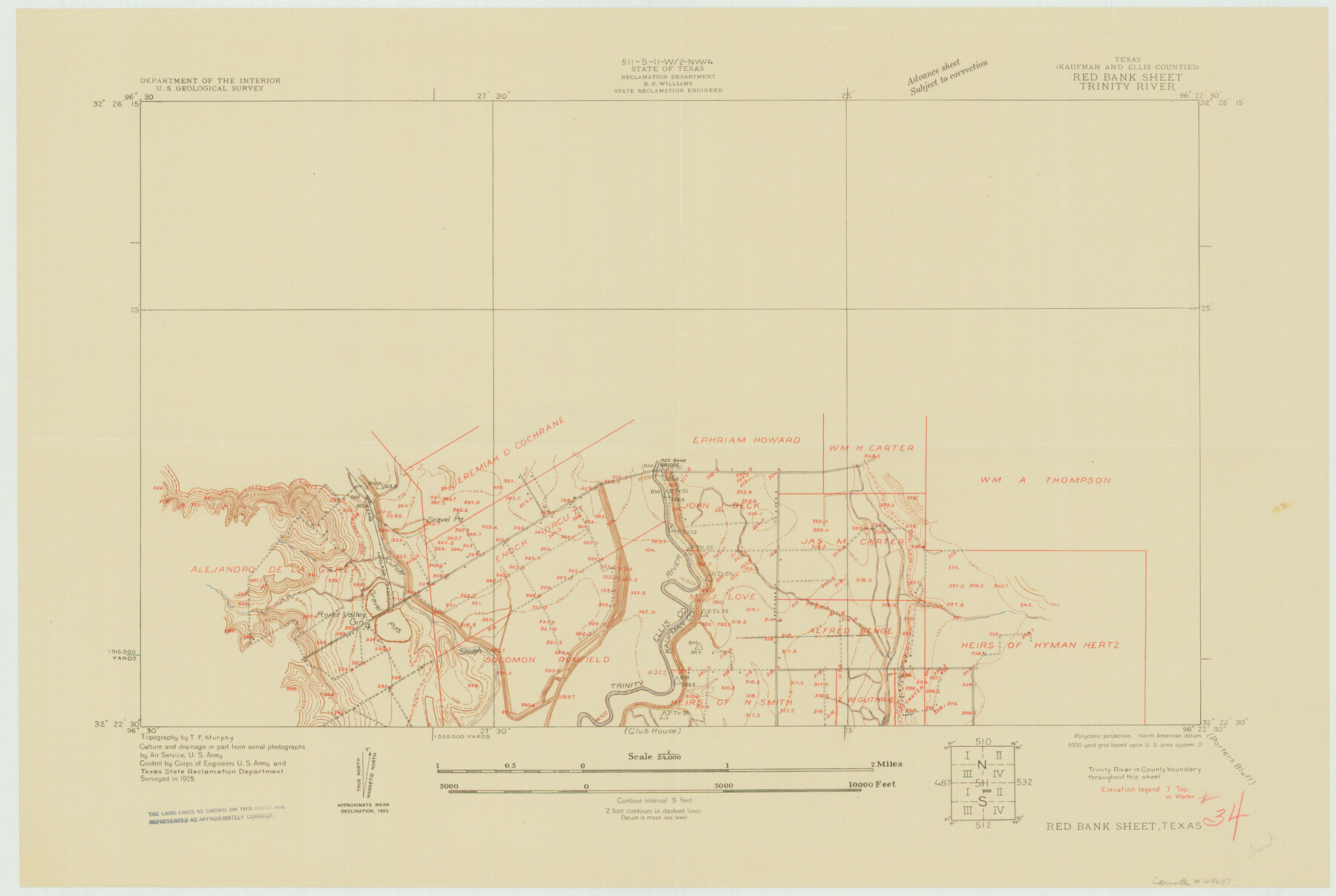
Trinity River, Red Bank Sheet
-
Map/Doc
69687
-
Collection
General Map Collection
-
Object Dates
1925 (Creation Date)
-
People and Organizations
Texas State Reclamation Department (Publisher)
T.F. Murphy (Surveyor/Engineer)
-
Counties
Kaufman Ellis
-
Subjects
River Surveys Topographic
-
Height x Width
16.4 x 24.4 inches
41.7 x 62.0 cm
-
Comments
Red Bank Sheet located north of the Club House Sheet and northwest of the Porters Bluff Sheet.
Part of: General Map Collection
Millennium in Maps - Exploration

Millennium in Maps - Exploration
Size 20.6 x 31.5 inches
Map/Doc 95931
Wise County Sketch File 34

Print $6.00
- Digital $50.00
Wise County Sketch File 34
1856
Size 6.3 x 9.6 inches
Map/Doc 40592
Van Zandt County Working Sketch 19

Print $20.00
- Digital $50.00
Van Zandt County Working Sketch 19
Size 43.3 x 32.8 inches
Map/Doc 72269
Waller County Sketch File 1

Print $14.00
- Digital $50.00
Waller County Sketch File 1
Size 8.1 x 6.9 inches
Map/Doc 39563
Field Notes of a Survey of Padre Island

Print $20.00
- Digital $50.00
Field Notes of a Survey of Padre Island
1941
Size 43.2 x 30.0 inches
Map/Doc 2271
[Location Survey of the Southern Kansas Railway, Kiowa Extension from a point in Drake's Location, in Indian Territory 100 miles from south line of Kansas, continuing up Wolf Creek and South Canadian River to Cottonwood Creek in Hutchinson County]
![88843, [Location Survey of the Southern Kansas Railway, Kiowa Extension from a point in Drake's Location, in Indian Territory 100 miles from south line of Kansas, continuing up Wolf Creek and South Canadian River to Cottonwood Creek in Hutchinson County], General Map Collection](https://historictexasmaps.com/wmedia_w700/maps/88843.tif.jpg)
Print $20.00
- Digital $50.00
[Location Survey of the Southern Kansas Railway, Kiowa Extension from a point in Drake's Location, in Indian Territory 100 miles from south line of Kansas, continuing up Wolf Creek and South Canadian River to Cottonwood Creek in Hutchinson County]
1886
Size 39.0 x 40.0 inches
Map/Doc 88843

Edwards County Working Sketch 131

Print $20.00
- Digital $50.00
Edwards County Working Sketch 131
1984
Size 21.0 x 18.6 inches
Map/Doc 69007
Flight Mission No. CLL-1N, Frame 10, Willacy County

Print $20.00
- Digital $50.00
Flight Mission No. CLL-1N, Frame 10, Willacy County
1954
Size 18.5 x 22.1 inches
Map/Doc 86997
Fayette County

Print $40.00
- Digital $50.00
Fayette County
1978
Size 42.5 x 54.7 inches
Map/Doc 73146
Pecos County Working Sketch 8

Print $20.00
- Digital $50.00
Pecos County Working Sketch 8
1906
Size 15.4 x 14.8 inches
Map/Doc 71478
Neel's Creek of North Bosque

Print $2.00
- Digital $50.00
Neel's Creek of North Bosque
1847
Size 8.9 x 7.9 inches
Map/Doc 69755
You may also like
Crockett County Sketch File 91

Print $76.00
- Digital $50.00
Crockett County Sketch File 91
1968
Size 11.3 x 8.8 inches
Map/Doc 19918
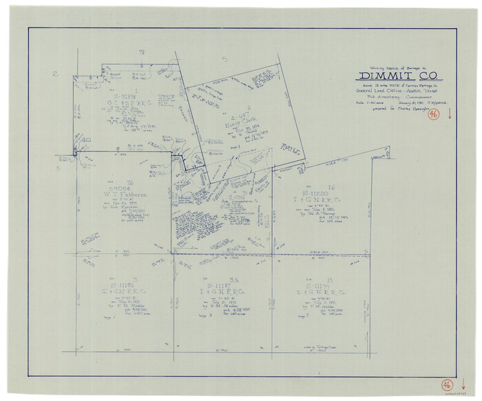
Dimmit County Working Sketch 46
Print $20.00
- Digital $50.00
Dimmit County Working Sketch 46
1980
Size 25.7 x 31.0 inches
Map/Doc 68707
United States - Gulf Coast Texas - Northern part of Laguna Madre

Print $20.00
- Digital $50.00
United States - Gulf Coast Texas - Northern part of Laguna Madre
1923
Size 26.9 x 18.4 inches
Map/Doc 72929
Midland County Sketch File 5

Print $2.00
- Digital $50.00
Midland County Sketch File 5
Size 8.4 x 3.5 inches
Map/Doc 31575
Calhoun County NRC Article 33.136 Sketch 8

Print $28.00
- Digital $50.00
Calhoun County NRC Article 33.136 Sketch 8
2019
Size 17.9 x 23.8 inches
Map/Doc 95371
[Surveys in the Bexar District along the Atascosa Creek]
![163, [Surveys in the Bexar District along the Atascosa Creek], General Map Collection](https://historictexasmaps.com/wmedia_w700/maps/163.tif.jpg)
Print $3.00
- Digital $50.00
[Surveys in the Bexar District along the Atascosa Creek]
1847
Size 16.9 x 11.6 inches
Map/Doc 163
Uvalde County Working Sketch 47

Print $20.00
- Digital $50.00
Uvalde County Working Sketch 47
1979
Size 29.7 x 24.8 inches
Map/Doc 72117
Liberty County Working Sketch 50

Print $20.00
- Digital $50.00
Liberty County Working Sketch 50
1955
Size 22.4 x 33.5 inches
Map/Doc 70510
Bailey County Sketch File 11a

Print $4.00
- Digital $50.00
Bailey County Sketch File 11a
1912
Size 8.4 x 11.1 inches
Map/Doc 13967
Runnels County Working Sketch 29

Print $20.00
- Digital $50.00
Runnels County Working Sketch 29
1959
Size 27.1 x 30.0 inches
Map/Doc 63625
Travis County Working Sketch 18

Print $20.00
- Digital $50.00
Travis County Working Sketch 18
1945
Size 30.4 x 42.9 inches
Map/Doc 69402
