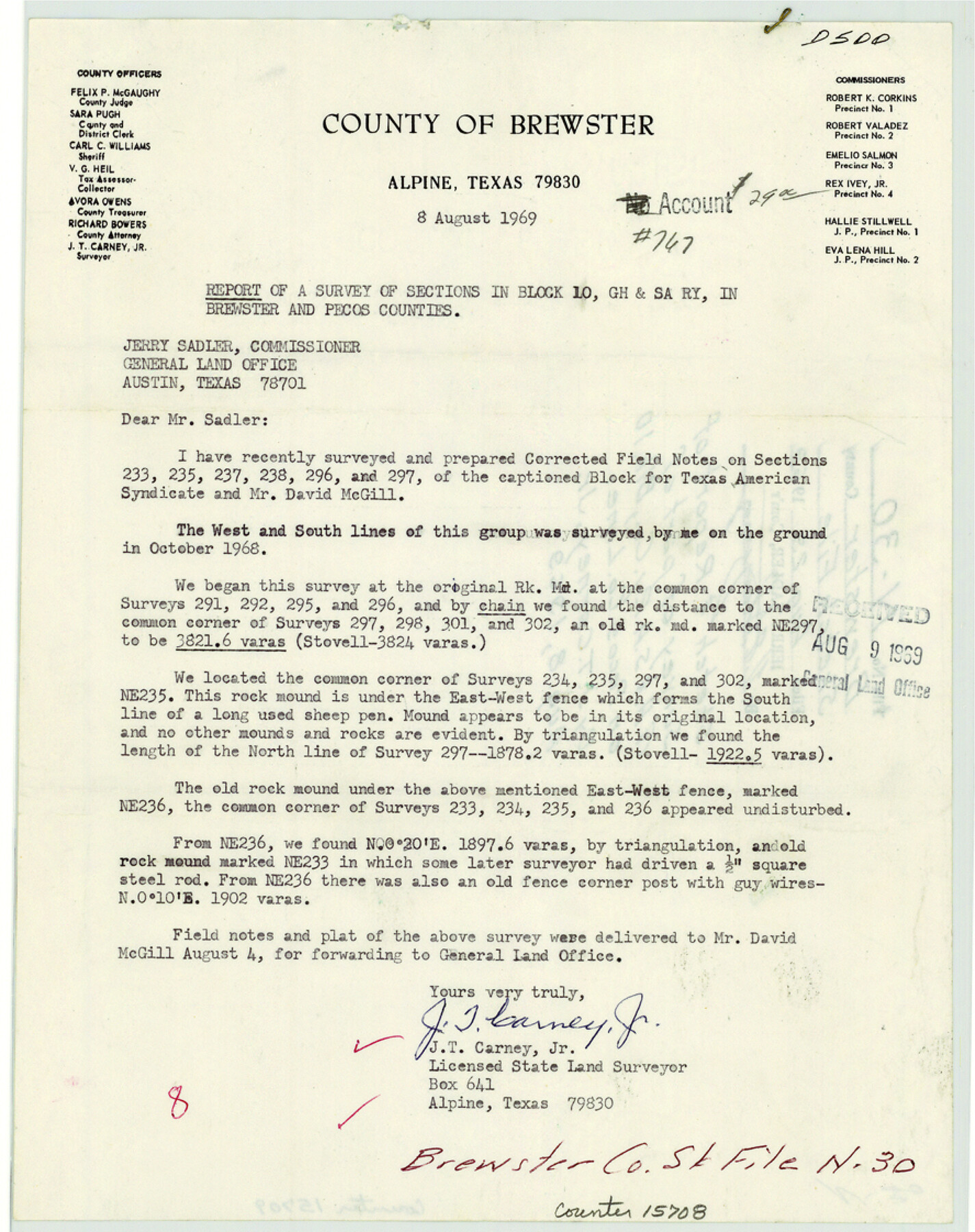
Brewster County Sketch File N-30
[Sketch and report of a survey of sections in Block 10, G. H. & S. A. Ry. on Brewster-Pecos county line]
-
Map/Doc
15708
-
Collection
General Map Collection
-
Object Dates
1969/8/8 (Creation Date)
1969/8/29 (File Date)
1968 (Survey Date)
1969 (Survey Date)
-
People and Organizations
J.T. Carney, Jr. (Surveyor/Engineer)
-
Counties
Brewster Pecos
-
Subjects
Surveying Sketch File
-
Height x Width
11.2 x 8.9 inches
28.4 x 22.6 cm
-
Medium
multi-page, multi-format
-
Features
U.S. Highway 67
Part of: General Map Collection
Culberson County Sketch File 29

Print $20.00
- Digital $50.00
Culberson County Sketch File 29
1949
Size 20.3 x 16.4 inches
Map/Doc 11270
Jackson County Sketch File 25

Print $20.00
- Digital $50.00
Jackson County Sketch File 25
1942
Size 15.4 x 37.4 inches
Map/Doc 11845
Orange County Working Sketch 12

Print $20.00
- Digital $50.00
Orange County Working Sketch 12
1922
Size 17.2 x 12.7 inches
Map/Doc 71344
Panola County Rolled Sketch 4

Print $20.00
- Digital $50.00
Panola County Rolled Sketch 4
1951
Size 25.4 x 26.1 inches
Map/Doc 7198
Val Verde County Working Sketch 34

Print $20.00
- Digital $50.00
Val Verde County Working Sketch 34
1940
Size 33.7 x 27.9 inches
Map/Doc 72169
Brazoria County Working Sketch 14

Print $20.00
- Digital $50.00
Brazoria County Working Sketch 14
1940
Size 33.6 x 43.9 inches
Map/Doc 67499
Falls of St. Anthony

Print $2.00
- Digital $50.00
Falls of St. Anthony
1810
Size 6.2 x 8.8 inches
Map/Doc 95152
Childress County Sketch File 7

Print $20.00
- Digital $50.00
Childress County Sketch File 7
Size 14.9 x 17.6 inches
Map/Doc 11079
Brazoria County Working Sketch 5

Print $20.00
- Digital $50.00
Brazoria County Working Sketch 5
1921
Size 15.1 x 17.1 inches
Map/Doc 67490
Flight Mission No. CRC-2R, Frame 184, Chambers County

Print $20.00
- Digital $50.00
Flight Mission No. CRC-2R, Frame 184, Chambers County
1956
Size 18.6 x 22.2 inches
Map/Doc 84762
Harris County Sketch File 54

Print $6.00
- Digital $50.00
Harris County Sketch File 54
Size 14.5 x 8.8 inches
Map/Doc 25451
Hardin County Sketch File 28

Print $4.00
- Digital $50.00
Hardin County Sketch File 28
Size 5.9 x 5.8 inches
Map/Doc 25153
You may also like
[East Line, Hemphill County]
![90725, [East Line, Hemphill County], Twichell Survey Records](https://historictexasmaps.com/wmedia_w700/maps/90725-1.tif.jpg)
Print $2.00
- Digital $50.00
[East Line, Hemphill County]
Size 5.4 x 15.0 inches
Map/Doc 90725
Andrews County Rolled Sketch 39

Print $20.00
- Digital $50.00
Andrews County Rolled Sketch 39
1979
Size 43.4 x 44.3 inches
Map/Doc 8401
Tom Green County Rolled Sketch 48

Print $20.00
- Digital $50.00
Tom Green County Rolled Sketch 48
1884
Size 14.3 x 22.7 inches
Map/Doc 8009
Working Sketch of surveys in Brazoria County, showing Cedar Lakes

Print $40.00
- Digital $50.00
Working Sketch of surveys in Brazoria County, showing Cedar Lakes
1950
Size 31.2 x 57.3 inches
Map/Doc 1932
Kendall County

Print $20.00
- Digital $50.00
Kendall County
1946
Size 41.6 x 35.9 inches
Map/Doc 1872
Crockett County Sketch File 81

Print $4.00
- Digital $50.00
Crockett County Sketch File 81
1939
Size 11.3 x 8.5 inches
Map/Doc 19893
Robertson & Scott V Ranch situated in Crosby County, Texas

Print $40.00
- Digital $50.00
Robertson & Scott V Ranch situated in Crosby County, Texas
Size 41.2 x 48.8 inches
Map/Doc 89758
Oldham County Working Sketch 6

Print $40.00
- Digital $50.00
Oldham County Working Sketch 6
1981
Size 32.4 x 50.4 inches
Map/Doc 71328
Dickens County Working Sketch 10

Print $40.00
- Digital $50.00
Dickens County Working Sketch 10
1965
Size 62.2 x 39.5 inches
Map/Doc 68658
Map of Asylum Lands

Print $20.00
- Digital $50.00
Map of Asylum Lands
1857
Size 22.0 x 29.1 inches
Map/Doc 2214
Mason County Working Sketch 23

Print $20.00
- Digital $50.00
Mason County Working Sketch 23
2004
Size 17.4 x 36.9 inches
Map/Doc 83577
Kleberg County Aerial Photograph Index Sheet 4

Print $20.00
- Digital $50.00
Kleberg County Aerial Photograph Index Sheet 4
1956
Size 19.3 x 23.3 inches
Map/Doc 83721