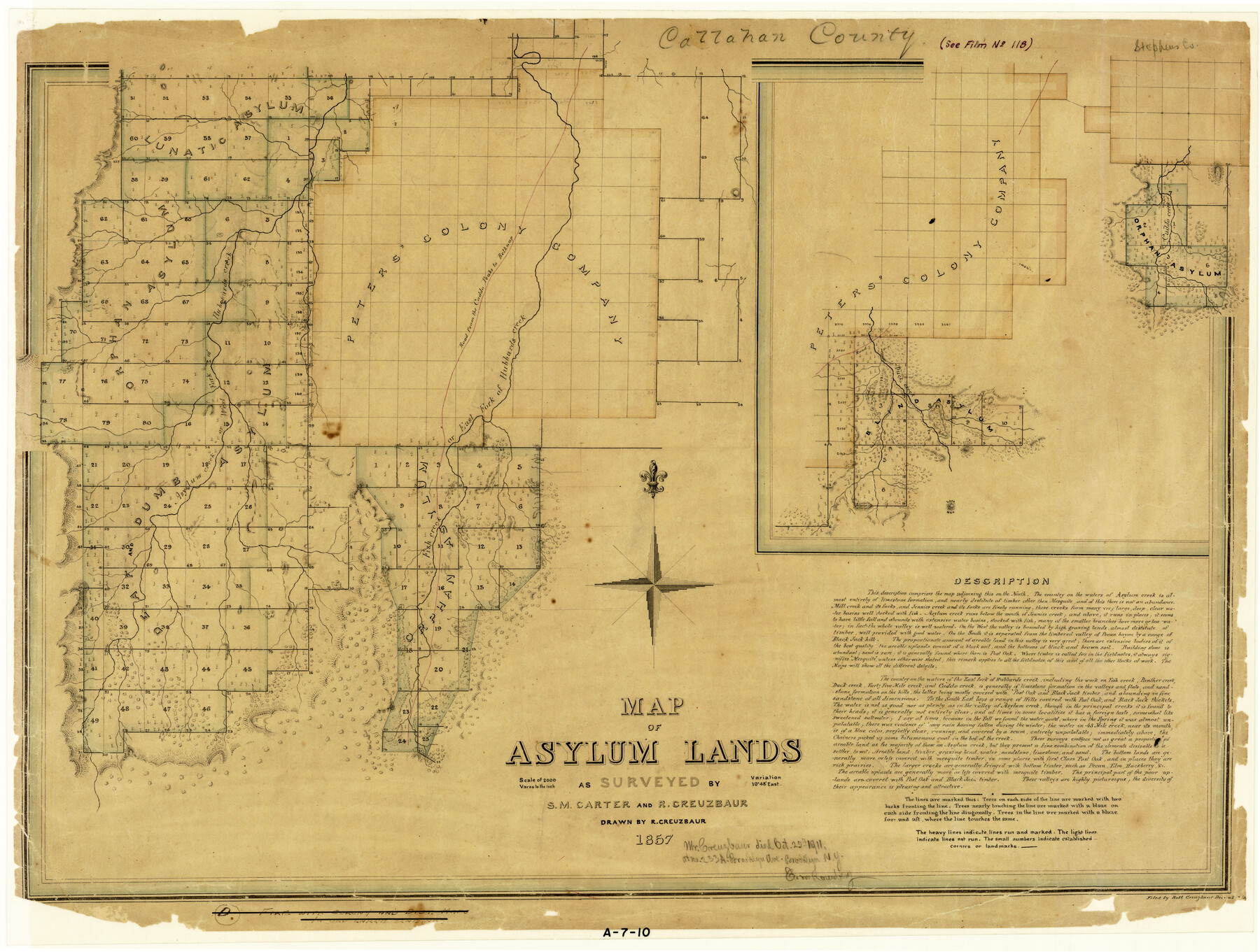
Map of Asylum Lands
A-7-10
-
Map/Doc
2214
-
Collection
General Map Collection
-
Object Dates
1857 (Creation Date)
-
People and Organizations
S.M. Carter (Surveyor/Engineer)
Robert Creuzbaur (Draftsman)
Robert Creuzbaur (Surveyor/Engineer)
-
Counties
Callahan
-
Subjects
County
-
Height x Width
22.0 x 29.1 inches
55.9 x 73.9 cm
-
Scale
1" = 2000 varas
Part of: General Map Collection
Hall County Sketch File 13

Print $20.00
- Digital $50.00
Hall County Sketch File 13
Size 15.7 x 24.2 inches
Map/Doc 11606
Jeff Davis County Sketch File 32

Print $20.00
- Digital $50.00
Jeff Davis County Sketch File 32
Size 23.8 x 18.8 inches
Map/Doc 11865
Robertson County Sketch File 4

Print $12.00
Robertson County Sketch File 4
1862
Size 11.0 x 8.0 inches
Map/Doc 35352
Current Miscellaneous File 73

Print $8.00
- Digital $50.00
Current Miscellaneous File 73
1959
Size 11.4 x 8.7 inches
Map/Doc 74177
University Lands Situated in Robertson County

Print $20.00
- Digital $50.00
University Lands Situated in Robertson County
1841
Size 22.8 x 26.2 inches
Map/Doc 281
Johnson County Working Sketch 31

Print $20.00
- Digital $50.00
Johnson County Working Sketch 31
2007
Size 21.2 x 22.0 inches
Map/Doc 87499
Flight Mission No. CGI-4N, Frame 20, Cameron County

Print $20.00
- Digital $50.00
Flight Mission No. CGI-4N, Frame 20, Cameron County
1954
Size 18.6 x 22.3 inches
Map/Doc 84653
Duval County Working Sketch 24

Print $20.00
- Digital $50.00
Duval County Working Sketch 24
1944
Size 40.0 x 27.3 inches
Map/Doc 68748
Sutton County Rolled Sketch 56

Print $20.00
- Digital $50.00
Sutton County Rolled Sketch 56
Size 23.6 x 28.0 inches
Map/Doc 7895
Blanco County Working Sketch 23

Print $40.00
- Digital $50.00
Blanco County Working Sketch 23
1962
Size 52.4 x 38.5 inches
Map/Doc 67383
Menard County Rolled Sketch 17

Print $20.00
- Digital $50.00
Menard County Rolled Sketch 17
1950
Size 23.2 x 26.3 inches
Map/Doc 6763
Jasper County Sketch File 3

Print $6.00
- Digital $50.00
Jasper County Sketch File 3
Size 10.1 x 15.2 inches
Map/Doc 27768
You may also like
Kenedy County Rolled Sketch 13

Print $20.00
- Digital $50.00
Kenedy County Rolled Sketch 13
1946
Size 38.2 x 45.5 inches
Map/Doc 9334
Stonewall County Working Sketch 18

Print $20.00
- Digital $50.00
Stonewall County Working Sketch 18
1956
Size 24.0 x 21.6 inches
Map/Doc 62325
San Patricio County NRC Article 33.136 Location Key Sheet

Print $20.00
- Digital $50.00
San Patricio County NRC Article 33.136 Location Key Sheet
1975
Size 27.0 x 23.0 inches
Map/Doc 77035
Plan of the City of Austin

Print $20.00
Plan of the City of Austin
1853
Size 13.9 x 11.5 inches
Map/Doc 76207
Andrews County Rolled Sketch 21

Print $20.00
- Digital $50.00
Andrews County Rolled Sketch 21
Size 18.2 x 26.3 inches
Map/Doc 77169
Flight Mission No. CRE-2R, Frame 154, Jackson County

Print $20.00
- Digital $50.00
Flight Mission No. CRE-2R, Frame 154, Jackson County
1956
Size 16.1 x 16.0 inches
Map/Doc 85365
Hartley County Sketch File 4

Print $6.00
- Digital $50.00
Hartley County Sketch File 4
1883
Size 10.6 x 8.1 inches
Map/Doc 26087
Current Miscellaneous File 27

Print $4.00
- Digital $50.00
Current Miscellaneous File 27
1952
Size 10.8 x 8.3 inches
Map/Doc 73909
Flight Mission No. CRE-1R, Frame 129, Jackson County

Print $20.00
- Digital $50.00
Flight Mission No. CRE-1R, Frame 129, Jackson County
1956
Size 18.5 x 22.3 inches
Map/Doc 85337
Travis County Working Sketch 14

Print $20.00
- Digital $50.00
Travis County Working Sketch 14
1937
Size 26.3 x 27.2 inches
Map/Doc 69398
Map Location of the Pecos & Northern Texas Railway from [illegible] through Deaf Smith County
![64180, Map Location of the Pecos & Northern Texas Railway from [illegible] through Deaf Smith County, General Map Collection](https://historictexasmaps.com/wmedia_w700/maps/64180-1.tif.jpg)
Print $40.00
- Digital $50.00
Map Location of the Pecos & Northern Texas Railway from [illegible] through Deaf Smith County
Size 16.3 x 71.8 inches
Map/Doc 64180
