Wichita County Rolled Sketch 14
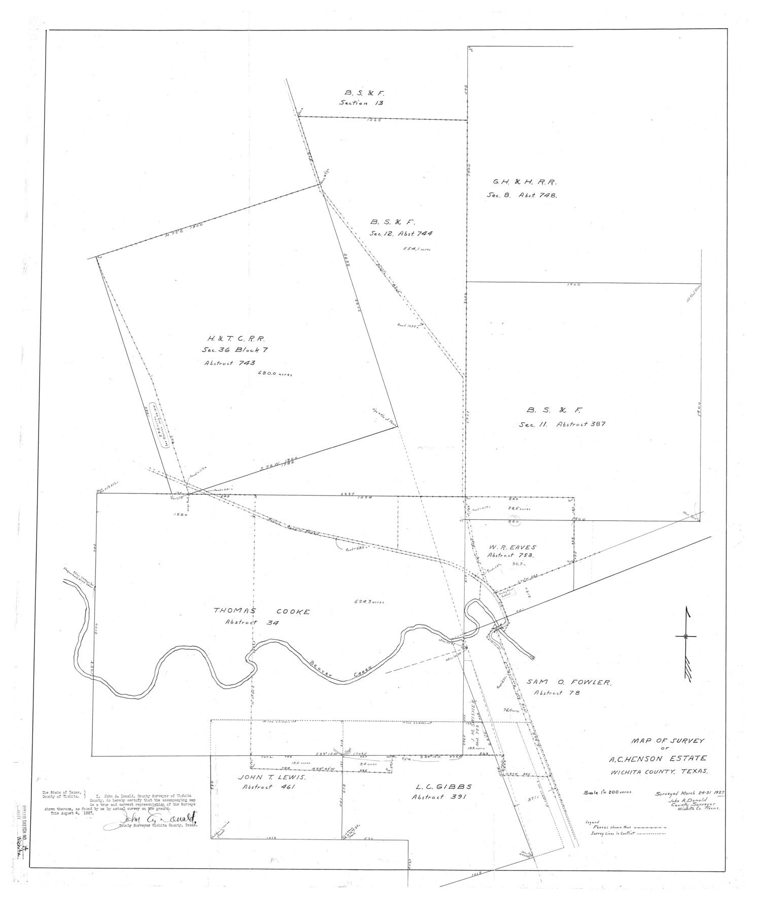
Map of survey of A.C. Henson estate, Wichita County, Texas
-
Map/Doc
8251
-
Collection
General Map Collection
-
Object Dates
1927/3/31 (Survey Date)
1927/8/18 (File Date)
1927/8/4 (Creation Date)
-
People and Organizations
John A. Donald (Surveyor/Engineer)
-
Counties
Wichita
-
Subjects
Surveying Rolled Sketch
-
Height x Width
36.7 x 30.5 inches
93.2 x 77.5 cm
-
Scale
1" = 200 varas
Part of: General Map Collection
Webb County Rolled Sketch 61

Print $20.00
- Digital $50.00
Webb County Rolled Sketch 61
1947
Size 38.6 x 36.5 inches
Map/Doc 10128
Guadalupe County Sketch File 7b

Print $4.00
- Digital $50.00
Guadalupe County Sketch File 7b
Size 7.3 x 10.9 inches
Map/Doc 24670
Webb County Sketch File 5a

Print $8.00
- Digital $50.00
Webb County Sketch File 5a
1877
Size 12.9 x 8.2 inches
Map/Doc 39729
McMullen County Rolled Sketch 15

Print $20.00
- Digital $50.00
McMullen County Rolled Sketch 15
1948
Size 30.9 x 25.9 inches
Map/Doc 6732
Medina County Working Sketch 25

Print $20.00
- Digital $50.00
Medina County Working Sketch 25
1985
Size 37.6 x 42.9 inches
Map/Doc 70940
Crane County Working Sketch Graphic Index, Sheet A

Print $20.00
- Digital $50.00
Crane County Working Sketch Graphic Index, Sheet A
1945
Size 44.6 x 33.3 inches
Map/Doc 76507
Wood County Sketch File 9

Print $4.00
- Digital $50.00
Wood County Sketch File 9
1852
Size 7.4 x 8.9 inches
Map/Doc 40656
Flight Mission No. CUG-3P, Frame 22, Kleberg County

Print $20.00
- Digital $50.00
Flight Mission No. CUG-3P, Frame 22, Kleberg County
1956
Size 18.5 x 22.1 inches
Map/Doc 86232
Ochiltree County

Print $20.00
- Digital $50.00
Ochiltree County
1908
Size 40.9 x 37.1 inches
Map/Doc 16782
Jefferson County Working Sketch 26

Print $20.00
- Digital $50.00
Jefferson County Working Sketch 26
1977
Size 39.9 x 36.8 inches
Map/Doc 66569
Nueces County Rolled Sketch 108

Print $62.00
Nueces County Rolled Sketch 108
1987
Size 18.6 x 23.5 inches
Map/Doc 7112
Webb County Sketch File 10-1

Print $20.00
- Digital $50.00
Webb County Sketch File 10-1
1850
Size 14.8 x 15.5 inches
Map/Doc 12625
You may also like
Mexico and Guatimala

Print $20.00
- Digital $50.00
Mexico and Guatimala
1828
Size 9.4 x 11.4 inches
Map/Doc 97524
Sketch in Terry & Yoakum Counties

Print $20.00
- Digital $50.00
Sketch in Terry & Yoakum Counties
1945
Size 21.8 x 40.0 inches
Map/Doc 92854
Current Miscellaneous File 5

Print $8.00
- Digital $50.00
Current Miscellaneous File 5
1946
Size 11.3 x 8.8 inches
Map/Doc 73727
Flight Mission No. DQO-3K, Frame 41, Galveston County

Print $20.00
- Digital $50.00
Flight Mission No. DQO-3K, Frame 41, Galveston County
1952
Size 18.7 x 22.5 inches
Map/Doc 85082
Wilson County Rolled Sketch 1

Print $20.00
- Digital $50.00
Wilson County Rolled Sketch 1
1941
Size 31.5 x 27.1 inches
Map/Doc 8367
Flight Mission No. DIX-8P, Frame 70, Aransas County

Print $20.00
- Digital $50.00
Flight Mission No. DIX-8P, Frame 70, Aransas County
1956
Size 18.7 x 22.4 inches
Map/Doc 83901
Sketch in Lynn, Terry, Gaines and Dawson Counties

Print $40.00
- Digital $50.00
Sketch in Lynn, Terry, Gaines and Dawson Counties
1940
Size 53.2 x 33.1 inches
Map/Doc 92060
United States - Gulf Coast - Galveston to Rio Grande

Print $20.00
- Digital $50.00
United States - Gulf Coast - Galveston to Rio Grande
1919
Size 27.1 x 18.3 inches
Map/Doc 72749
Denton County Working Sketch 19

Print $20.00
- Digital $50.00
Denton County Working Sketch 19
1976
Size 24.3 x 27.3 inches
Map/Doc 68624
Nueces County Rolled Sketch 42

Print $45.00
Nueces County Rolled Sketch 42
1970
Size 27.6 x 39.2 inches
Map/Doc 6880
Flight Mission No. DQN-2K, Frame 77, Calhoun County

Print $20.00
- Digital $50.00
Flight Mission No. DQN-2K, Frame 77, Calhoun County
1953
Size 16.1 x 15.9 inches
Map/Doc 84269
Nacogdoches County Boundary File 1

Print $36.00
- Digital $50.00
Nacogdoches County Boundary File 1
Size 6.7 x 4.4 inches
Map/Doc 57562