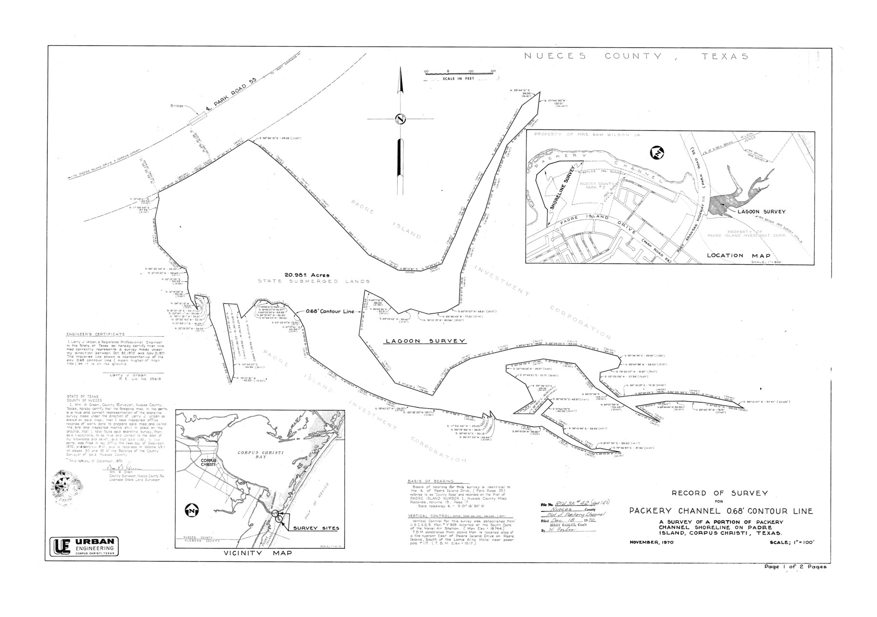
Nueces County Rolled Sketch 42
[Sketches of two portions of the shoreline of "Packery Channel"]
-
Map/Doc
6880
-
Collection
General Map Collection
-
Object Dates
11/1970 (Creation Date)
12/18/1970 (File Date)
-
People and Organizations
Larry J. Urban (Surveyor/Engineer)
Wm. W. Green (Surveyor/Engineer)
-
Counties
Nueces
-
Subjects
Surveying Rolled Sketch
-
Height x Width
27.6 x 39.2 inches
70.1 x 99.6 cm
-
Scale
1" = 100 feet
Part of: General Map Collection
Uvalde County Rolled Sketch 16

Print $20.00
- Digital $50.00
Uvalde County Rolled Sketch 16
Size 36.6 x 25.1 inches
Map/Doc 8100
Montague County Sketch File 13

Print $4.00
- Digital $50.00
Montague County Sketch File 13
1879
Size 8.9 x 9.0 inches
Map/Doc 31738
Edwards County Working Sketch 125

Print $20.00
- Digital $50.00
Edwards County Working Sketch 125
1977
Size 22.3 x 23.5 inches
Map/Doc 69001
Flight Mission No. CGI-4N, Frame 182, Cameron County

Print $20.00
- Digital $50.00
Flight Mission No. CGI-4N, Frame 182, Cameron County
1955
Size 18.4 x 22.2 inches
Map/Doc 84685
Lavaca County Sketch File 10

Print $4.00
- Digital $50.00
Lavaca County Sketch File 10
1890
Size 7.5 x 11.5 inches
Map/Doc 29648
Cameron County Rolled Sketch Z1

Print $20.00
- Digital $50.00
Cameron County Rolled Sketch Z1
1937
Size 23.4 x 41.4 inches
Map/Doc 5401
Flight Mission No. CRC-2R, Frame 138, Chambers County

Print $20.00
- Digital $50.00
Flight Mission No. CRC-2R, Frame 138, Chambers County
1956
Size 18.7 x 22.4 inches
Map/Doc 84754
Map of Europe to illustrate Olney's school geography (Inset: Central Europe)

Print $20.00
- Digital $50.00
Map of Europe to illustrate Olney's school geography (Inset: Central Europe)
1844
Size 12.1 x 19.0 inches
Map/Doc 93546

Montague County Rolled Sketch 2

Print $20.00
- Digital $50.00
Montague County Rolled Sketch 2
1940
Size 32.5 x 35.5 inches
Map/Doc 9525
Surveys on the Coleto Creek, Goliad County

Print $20.00
- Digital $50.00
Surveys on the Coleto Creek, Goliad County
1841
Size 13.8 x 14.9 inches
Map/Doc 10
[Surveys along Richland Creek]
![322, [Surveys along Richland Creek], General Map Collection](https://historictexasmaps.com/wmedia_w700/maps/322.tif.jpg)
Print $2.00
- Digital $50.00
[Surveys along Richland Creek]
Size 6.0 x 5.0 inches
Map/Doc 322
You may also like
Starr County Working Sketch 29

Print $20.00
- Digital $50.00
Starr County Working Sketch 29
2007
Size 28.6 x 34.0 inches
Map/Doc 87208
Mason County Sketch File 12

Print $22.00
- Digital $50.00
Mason County Sketch File 12
Size 15.8 x 12.9 inches
Map/Doc 30699
Treaty to Resolve Pending Boundary Differences and Maintain the Rio Grande and Colorado River as the International Boundary Between the United States of American and Mexico

Print $4.00
- Digital $50.00
Treaty to Resolve Pending Boundary Differences and Maintain the Rio Grande and Colorado River as the International Boundary Between the United States of American and Mexico
1970
Size 12.1 x 19.0 inches
Map/Doc 83099
Culberson County Rolled Sketch 52

Print $20.00
- Digital $50.00
Culberson County Rolled Sketch 52
Size 18.7 x 24.8 inches
Map/Doc 5675
Flight Mission No. DQO-1K, Frame 150, Galveston County

Print $20.00
- Digital $50.00
Flight Mission No. DQO-1K, Frame 150, Galveston County
1952
Size 19.1 x 22.6 inches
Map/Doc 85003
Jeff Davis County Sketch File 43

Print $10.00
- Digital $50.00
Jeff Davis County Sketch File 43
1970
Size 14.2 x 8.6 inches
Map/Doc 28066
Baylor County Sketch File 23a

Print $10.00
- Digital $50.00
Baylor County Sketch File 23a
1927
Size 14.3 x 8.9 inches
Map/Doc 14204
Runnels County Sketch File 6

Print $5.00
Runnels County Sketch File 6
1872
Size 9.9 x 15.9 inches
Map/Doc 35440
Montgomery County Boundary File 1

Print $4.00
- Digital $50.00
Montgomery County Boundary File 1
Size 5.8 x 5.5 inches
Map/Doc 57446

Ward County Working Sketch 13

Print $20.00
- Digital $50.00
Ward County Working Sketch 13
1947
Size 20.0 x 40.6 inches
Map/Doc 72319
Loving County Working Sketch 18

Print $40.00
- Digital $50.00
Loving County Working Sketch 18
1978
Size 65.2 x 43.2 inches
Map/Doc 70652