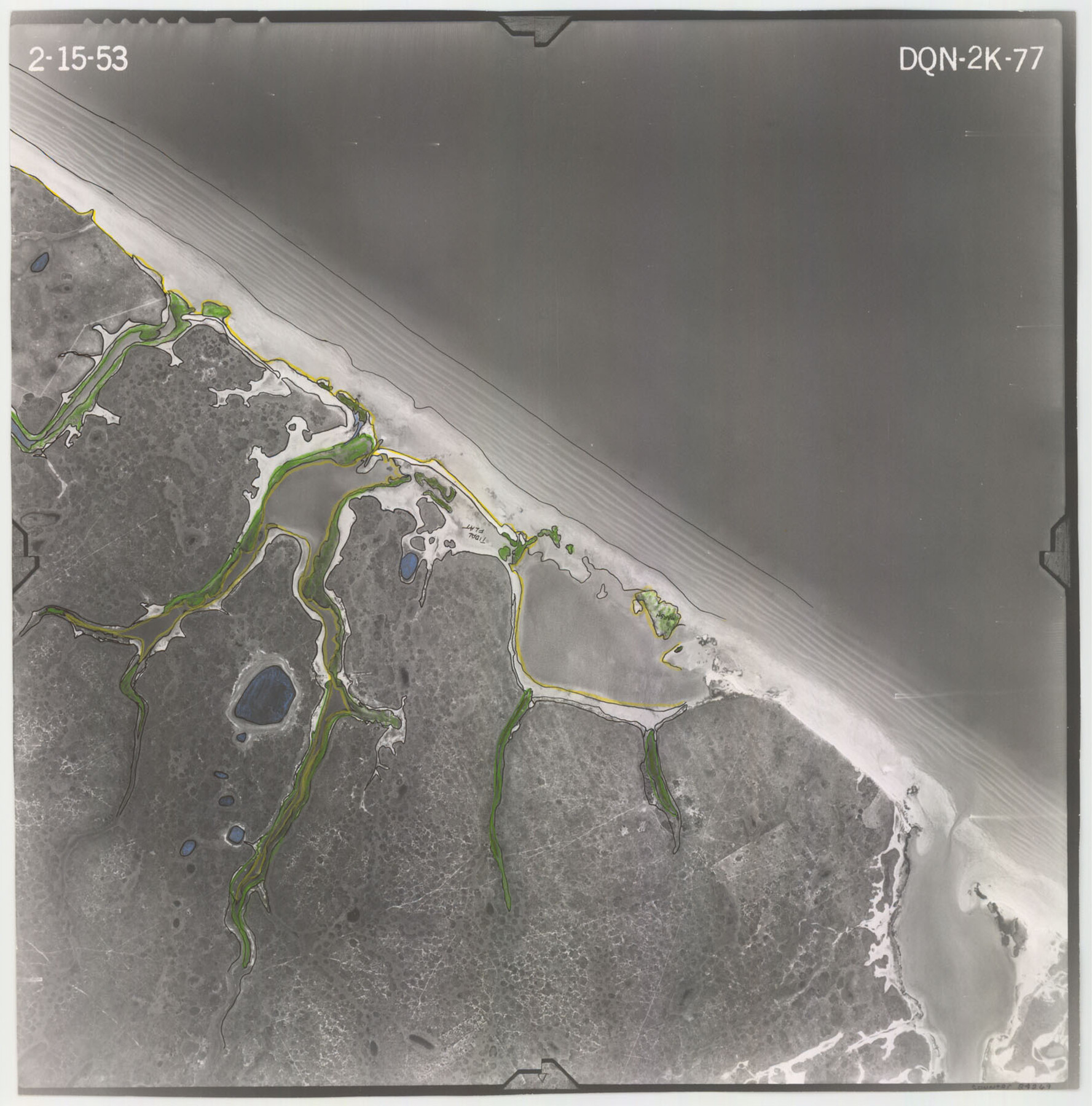
Flight Mission No. DQN-2K, Frame 77, Calhoun County
DQN-2K-77
-
Map/Doc
84269
-
Collection
General Map Collection
-
Object Dates
1953/2/15 (Creation Date)
-
People and Organizations
U. S. Department of Agriculture (Publisher)
-
Counties
Calhoun
-
Subjects
Aerial Photograph
-
Height x Width
16.1 x 15.9 inches
40.9 x 40.4 cm
-
Comments
Flown by Aero Exploration Company of Tulsa, Oklahoma.
Part of: General Map Collection
Nueces County Working Sketch 7

Print $40.00
- Digital $50.00
Nueces County Working Sketch 7
1972
Size 26.9 x 72.6 inches
Map/Doc 71309
Burnet County Sketch File 24

Print $8.00
- Digital $50.00
Burnet County Sketch File 24
1872
Size 7.9 x 10.2 inches
Map/Doc 16721
Clay County Sketch File 14

Print $40.00
- Digital $50.00
Clay County Sketch File 14
1873
Size 16.5 x 13.8 inches
Map/Doc 18417
Hutchinson County Sketch File 17

Print $4.00
- Digital $50.00
Hutchinson County Sketch File 17
Size 6.9 x 8.8 inches
Map/Doc 27218
Glasscock County Working Sketch 3

Print $20.00
- Digital $50.00
Glasscock County Working Sketch 3
Size 16.8 x 28.0 inches
Map/Doc 63176
Wheeler County Sketch File 11

Print $47.00
- Digital $50.00
Wheeler County Sketch File 11
1992
Size 11.5 x 9.0 inches
Map/Doc 40014
Flight Mission No. DCL-4C, Frame 5, Kenedy County

Print $20.00
- Digital $50.00
Flight Mission No. DCL-4C, Frame 5, Kenedy County
1943
Size 18.6 x 22.3 inches
Map/Doc 85806
Hudspeth County Sketch File 37

Print $80.00
- Digital $50.00
Hudspeth County Sketch File 37
Size 12.5 x 98.3 inches
Map/Doc 27008
Midland County Working Sketch 1

Print $20.00
- Digital $50.00
Midland County Working Sketch 1
Size 26.8 x 8.7 inches
Map/Doc 70981

Val Verde County Rolled Sketch 3

Print $20.00
- Digital $50.00
Val Verde County Rolled Sketch 3
1887
Size 44.8 x 36.5 inches
Map/Doc 10070

You may also like
Outer Continental Shelf Leasing Maps (Louisiana Offshore Operations)

Print $20.00
- Digital $50.00
Outer Continental Shelf Leasing Maps (Louisiana Offshore Operations)
1955
Size 14.0 x 12.8 inches
Map/Doc 76085
Floyd County Sketch File 30

Print $20.00
- Digital $50.00
Floyd County Sketch File 30
Size 12.6 x 33.9 inches
Map/Doc 11489
Working Sketch Armstrong County

Print $20.00
- Digital $50.00
Working Sketch Armstrong County
1909
Size 32.0 x 23.8 inches
Map/Doc 90264
[Surveys made in Peters Colony by Thomas Leckie]
![1983, [Surveys made in Peters Colony by Thomas Leckie], General Map Collection](https://historictexasmaps.com/wmedia_w700/maps/1983.tif.jpg)
Print $20.00
- Digital $50.00
[Surveys made in Peters Colony by Thomas Leckie]
1858
Size 22.9 x 16.6 inches
Map/Doc 1983
Reagan County Working Sketch 48

Print $20.00
- Digital $50.00
Reagan County Working Sketch 48
1987
Size 31.6 x 46.1 inches
Map/Doc 71891
Brewster County Rolled Sketch 74

Print $20.00
- Digital $50.00
Brewster County Rolled Sketch 74
1941
Size 22.8 x 15.8 inches
Map/Doc 5240
Galveston County Sketch File 73I

Print $20.00
- Digital $50.00
Galveston County Sketch File 73I
Size 31.5 x 26.0 inches
Map/Doc 11543
Working Sketch Cochran and Yoakum Co's.

Print $40.00
- Digital $50.00
Working Sketch Cochran and Yoakum Co's.
1919
Size 54.5 x 16.4 inches
Map/Doc 89688
Head of Cowhouse Cr.

Print $2.00
- Digital $50.00
Head of Cowhouse Cr.
1846
Size 6.4 x 13.7 inches
Map/Doc 271
Bexar County Sketch File 55

Print $20.00
- Digital $50.00
Bexar County Sketch File 55
1838
Size 13.3 x 8.3 inches
Map/Doc 14560
Trinity County

Print $20.00
- Digital $50.00
Trinity County
1946
Size 40.5 x 40.7 inches
Map/Doc 77440
Val Verde County, Texas, E. L. & R. R. Ry. Block D7 showing beginning point and direction of certain surveys

Print $20.00
- Digital $50.00
Val Verde County, Texas, E. L. & R. R. Ry. Block D7 showing beginning point and direction of certain surveys
1937
Size 22.1 x 17.0 inches
Map/Doc 91950