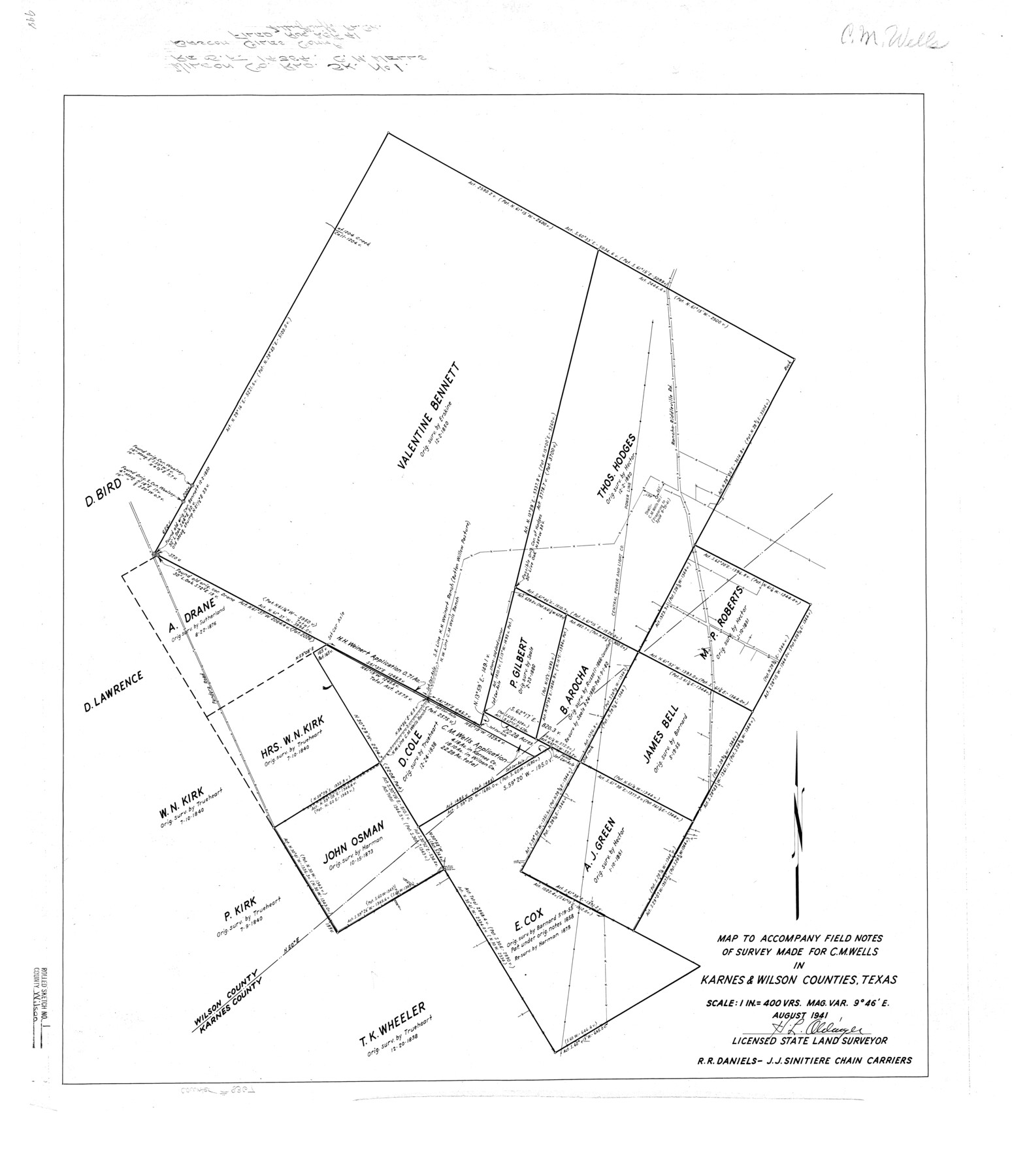
Wilson County Rolled Sketch 1
Map to accompany field notes of survey made for C.M. Wells in Karnes & Wilson Counties, Texas
-
Map/Doc
8367
-
Collection
General Map Collection
-
Object Dates
1941 (Creation Date)
1941/8/29 (File Date)
-
People and Organizations
H.L. Oldinger (Surveyor/Engineer)
R.R.Daniels (Chainman/Field Personnel)
J.J. Sinitiere (Chainman/Field Personnel)
-
Counties
Wilson Karnes
-
Subjects
Surveying Rolled Sketch
-
Height x Width
31.5 x 27.1 inches
80.0 x 68.8 cm
-
Scale
1" = 400 varas
Part of: General Map Collection
Lubbock County Sketch File 6

Print $20.00
- Digital $50.00
Lubbock County Sketch File 6
1902
Size 33.0 x 20.8 inches
Map/Doc 12017
Gonzales County

Print $40.00
- Digital $50.00
Gonzales County
1920
Size 40.3 x 51.8 inches
Map/Doc 4959
Maverick County Sketch File 18

Print $14.00
- Digital $50.00
Maverick County Sketch File 18
1886
Size 12.8 x 8.1 inches
Map/Doc 31121
[Blanco County]
![3307, [Blanco County], General Map Collection](https://historictexasmaps.com/wmedia_w700/maps/3307-2.tif.jpg)
Print $20.00
- Digital $50.00
[Blanco County]
1872
Size 19.1 x 16.0 inches
Map/Doc 3307
Irion County Working Sketch 11

Print $20.00
- Digital $50.00
Irion County Working Sketch 11
1959
Size 43.6 x 30.6 inches
Map/Doc 66420
The American Military Pocket Atlas; being an approved Collection of Correct Maps, both general and particular, of the British Colonies; Especially those which now are, or probably may be the Theatre of War

The American Military Pocket Atlas; being an approved Collection of Correct Maps, both general and particular, of the British Colonies; Especially those which now are, or probably may be the Theatre of War
1776
Map/Doc 97398
Presidio County Rolled Sketch S

Print $20.00
- Digital $50.00
Presidio County Rolled Sketch S
1915
Size 15.6 x 15.4 inches
Map/Doc 7413
Jack County Working Sketch 2

Print $20.00
- Digital $50.00
Jack County Working Sketch 2
1939
Size 10.9 x 17.7 inches
Map/Doc 66428
Bee County Working Sketch 2

Print $3.00
- Digital $50.00
Bee County Working Sketch 2
1914
Size 11.0 x 9.6 inches
Map/Doc 67252
Coleman County Sketch File 7

Print $2.00
- Digital $50.00
Coleman County Sketch File 7
Size 8.2 x 10.3 inches
Map/Doc 18674
Liberty County Working Sketch 53

Print $20.00
- Digital $50.00
Liberty County Working Sketch 53
1959
Size 31.1 x 34.4 inches
Map/Doc 70513
[Map of Connecting Lines along or near the Red River]
![75545, [Map of Connecting Lines along or near the Red River], General Map Collection](https://historictexasmaps.com/wmedia_w700/maps/75545.tif.jpg)
Print $40.00
- Digital $50.00
[Map of Connecting Lines along or near the Red River]
Size 37.9 x 48.7 inches
Map/Doc 75545
You may also like
Henderson County Sketch File 14

Print $4.00
- Digital $50.00
Henderson County Sketch File 14
1889
Size 10.7 x 7.3 inches
Map/Doc 26355
Wharton County Working Sketch 3

Print $20.00
- Digital $50.00
Wharton County Working Sketch 3
Size 17.5 x 16.4 inches
Map/Doc 72467
Gregg County Rolled Sketch 20

Print $20.00
- Digital $50.00
Gregg County Rolled Sketch 20
1957
Size 34.6 x 44.7 inches
Map/Doc 6478
Chambers County Working Sketch 9

Print $20.00
- Digital $50.00
Chambers County Working Sketch 9
1946
Size 43.9 x 29.8 inches
Map/Doc 67992
General Highway Map, Carson County, Texas

Print $20.00
General Highway Map, Carson County, Texas
1961
Size 18.2 x 24.9 inches
Map/Doc 79401
Starr County Sketch File 25

Print $42.00
- Digital $50.00
Starr County Sketch File 25
1921
Size 9.1 x 8.6 inches
Map/Doc 36927
Webb County Rolled Sketch 25

Print $20.00
- Digital $50.00
Webb County Rolled Sketch 25
Size 28.4 x 42.4 inches
Map/Doc 8185
Matagorda County Rolled Sketch 27

Print $40.00
- Digital $50.00
Matagorda County Rolled Sketch 27
1950
Size 41.7 x 59.6 inches
Map/Doc 9480
Burleson County Working Sketch 28

Print $20.00
- Digital $50.00
Burleson County Working Sketch 28
1981
Size 17.8 x 17.0 inches
Map/Doc 67747
[Sketch highlighting Bob Reid and Fred Turner surveys]
![91691, [Sketch highlighting Bob Reid and Fred Turner surveys], Twichell Survey Records](https://historictexasmaps.com/wmedia_w700/maps/91691-1.tif.jpg)
Print $3.00
- Digital $50.00
[Sketch highlighting Bob Reid and Fred Turner surveys]
Size 9.8 x 16.1 inches
Map/Doc 91691
Cooke County Sketch File 3

Print $2.00
- Digital $50.00
Cooke County Sketch File 3
1873
Size 6.3 x 7.7 inches
Map/Doc 19222
Garza County Sketch File 4

Print $6.00
- Digital $50.00
Garza County Sketch File 4
1883
Size 12.6 x 11.0 inches
Map/Doc 24046