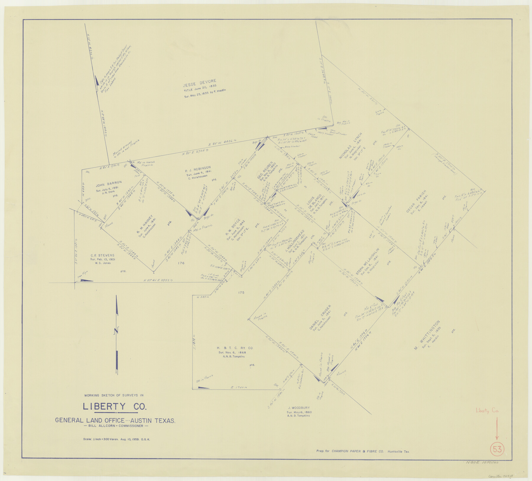
Liberty County Working Sketch 53
-
Map/Doc
70513
-
Collection
General Map Collection
-
Object Dates
8/10/1959 (Creation Date)
-
People and Organizations
Otto G. Kurio (Draftsman)
-
Counties
Liberty
-
Subjects
Surveying Working Sketch
-
Height x Width
31.1 x 34.4 inches
79.0 x 87.4 cm
-
Scale
1" = 300 varas
Part of: General Map Collection
Tom Green County Sketch File 46

Print $82.00
- Digital $50.00
Tom Green County Sketch File 46
1883
Size 28.4 x 28.6 inches
Map/Doc 10402
Newton County Sketch File 19

Print $20.00
- Digital $50.00
Newton County Sketch File 19
Size 22.8 x 9.4 inches
Map/Doc 42158
Louisiana and Texas Intracoastal Waterway

Print $20.00
- Digital $50.00
Louisiana and Texas Intracoastal Waterway
1929
Size 13.7 x 19.0 inches
Map/Doc 83344
Flight Mission No. DIX-10P, Frame 177, Aransas County

Print $20.00
- Digital $50.00
Flight Mission No. DIX-10P, Frame 177, Aransas County
1956
Size 18.6 x 22.3 inches
Map/Doc 83967
Flight Mission No. CRE-3R, Frame 40, Jackson County

Print $20.00
- Digital $50.00
Flight Mission No. CRE-3R, Frame 40, Jackson County
1956
Size 18.6 x 22.3 inches
Map/Doc 85387
[Sketch for Mineral Application 12206 - Cow Bayou, O. B. Sawyer]
![65568, [Sketch for Mineral Application 12206 - Cow Bayou, O. B. Sawyer], General Map Collection](https://historictexasmaps.com/wmedia_w700/maps/65568.tif.jpg)
Print $40.00
- Digital $50.00
[Sketch for Mineral Application 12206 - Cow Bayou, O. B. Sawyer]
Size 37.4 x 140.2 inches
Map/Doc 65568
Stephens County Boundary File 5

Print $8.00
- Digital $50.00
Stephens County Boundary File 5
Size 7.6 x 6.4 inches
Map/Doc 58897
Wilbarger County Sketch File 7

Print $4.00
- Digital $50.00
Wilbarger County Sketch File 7
1883
Size 12.7 x 8.3 inches
Map/Doc 40175
Flight Mission No. DIX-6P, Frame 197, Aransas County

Print $20.00
- Digital $50.00
Flight Mission No. DIX-6P, Frame 197, Aransas County
1956
Size 19.1 x 22.8 inches
Map/Doc 83859
Sherman County Boundary File 1

Print $20.00
- Digital $50.00
Sherman County Boundary File 1
Size 11.4 x 8.9 inches
Map/Doc 58751
Map of Webb County

Print $20.00
- Digital $50.00
Map of Webb County
1878
Size 37.0 x 26.0 inches
Map/Doc 4130
University Land, Lamar County

Print $20.00
- Digital $50.00
University Land, Lamar County
1906
Size 23.8 x 29.9 inches
Map/Doc 2431
You may also like
Terry County Sketch File 18

Print $36.00
- Digital $50.00
Terry County Sketch File 18
Size 8.9 x 11.4 inches
Map/Doc 38039
General Highway Map, Kerr County, Texas

Print $20.00
General Highway Map, Kerr County, Texas
1940
Size 24.8 x 18.2 inches
Map/Doc 79157
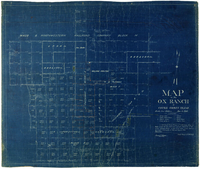
Map of the O-X Ranch in Cottle County, Texas
Print $20.00
- Digital $50.00
Map of the O-X Ranch in Cottle County, Texas
1916
Size 30.4 x 35.0 inches
Map/Doc 4438
Wheeler County Rolled Sketch 3

Print $20.00
- Digital $50.00
Wheeler County Rolled Sketch 3
Size 31.9 x 21.9 inches
Map/Doc 8239
Kinney County Sketch File 25

Print $20.00
- Digital $50.00
Kinney County Sketch File 25
1927
Size 19.1 x 18.9 inches
Map/Doc 11944
Brewster County Working Sketch 87

Print $40.00
- Digital $50.00
Brewster County Working Sketch 87
1973
Size 37.4 x 56.6 inches
Map/Doc 67687
Mills County Working Sketch Graphic Index

Print $20.00
- Digital $50.00
Mills County Working Sketch Graphic Index
1976
Size 35.6 x 45.1 inches
Map/Doc 76643
Real County Working Sketch 40

Print $20.00
- Digital $50.00
Real County Working Sketch 40
1952
Size 31.5 x 22.5 inches
Map/Doc 71932
Runnels County Working Sketch 2
Print $20.00
- Digital $50.00
Runnels County Working Sketch 2
Size 19.8 x 29.4 inches
Map/Doc 63598
Boundary Between the United States & Mexico Agreed upon by the Joint Commission under the Treaty of Guadalupe Hidalgo

Print $20.00
- Digital $50.00
Boundary Between the United States & Mexico Agreed upon by the Joint Commission under the Treaty of Guadalupe Hidalgo
1853
Size 18.2 x 26.4 inches
Map/Doc 72883
El Paso County Boundary File 7a

Print $20.00
- Digital $50.00
El Paso County Boundary File 7a
Size 14.2 x 8.3 inches
Map/Doc 53094
Fort Bend County Sketch File 31

Print $10.00
- Digital $50.00
Fort Bend County Sketch File 31
1940
Size 13.3 x 8.7 inches
Map/Doc 22997