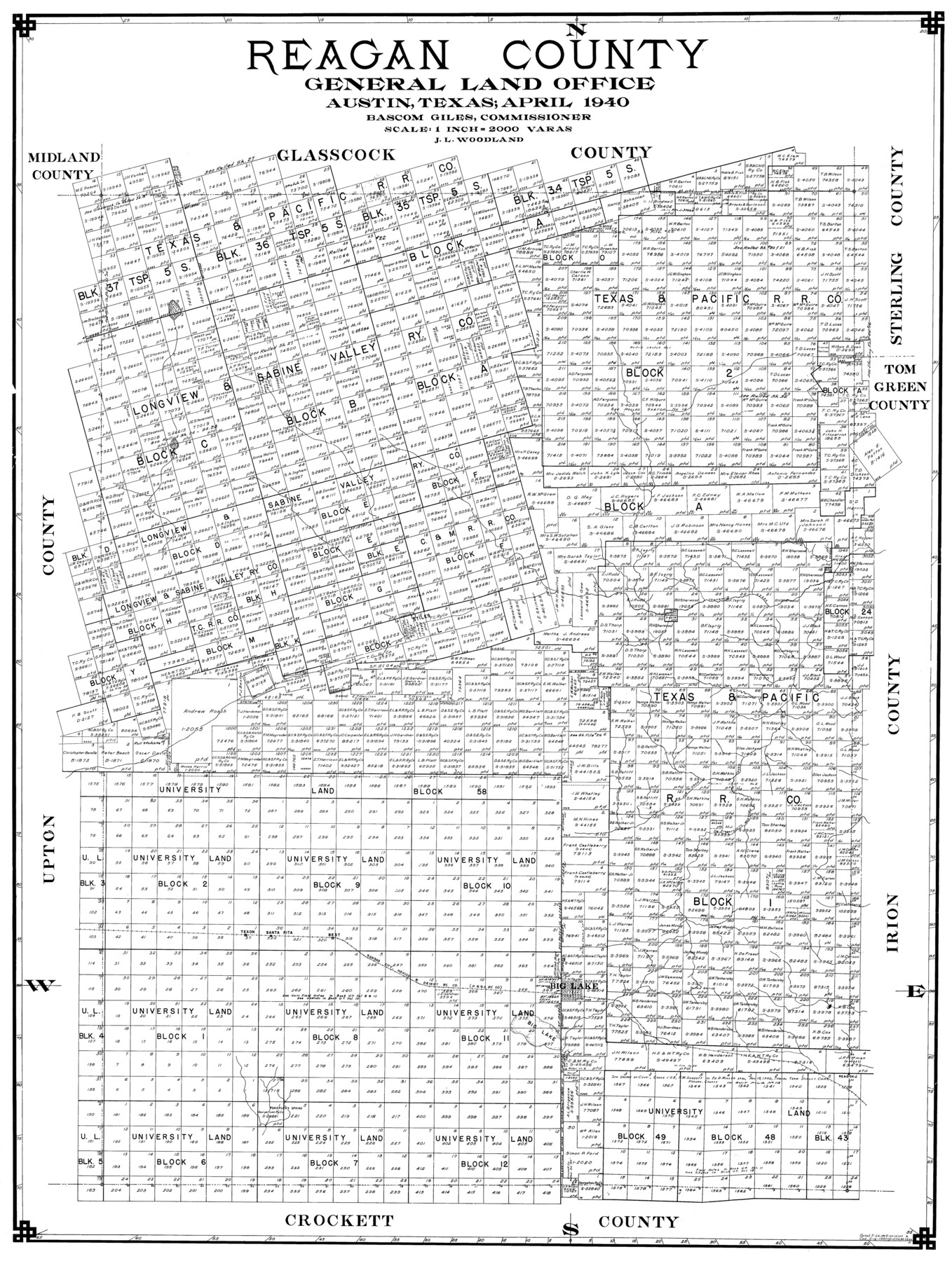
Reagan County
- 
                          Map/Doc77403
- 
                            CollectionGeneral Map Collection
- 
                            Object Dates1940 (Creation Date)
- 
                            People and OrganizationsEltea Armstrong (Draftsman)J.L. Woodland (Compiler)
- 
                            CountiesReagan
- 
                            SubjectsCounty
- 
                            Height x Width41.6 x 31.4 inches105.7 x 79.8 cm
Part of: General Map Collection
            Travis County Rolled Sketch 18


                                            Print $20.00                    
                                             -                         Digital $50.00                                    
                Travis County Rolled Sketch 18
1940
Size 28.8 x 21.1 inches
                                Map/Doc 8020
            
            Map of Jefferson County


                                            Print $20.00                    
                                             -                         Digital $50.00                                    
                Map of Jefferson County
1896
Size 26.7 x 23.2 inches
                                Map/Doc 66883
            
            Hopkins County Sketch File 3


                                            Print $4.00                    
                                             -                         Digital $50.00                                    
                Hopkins County Sketch File 3
Size 10.0 x 8.1 inches
                                Map/Doc 26685
            
            Flight Mission No. BRA-8M, Frame 123, Jefferson County


                                            Print $20.00                    
                                             -                         Digital $50.00                                    
                Flight Mission No. BRA-8M, Frame 123, Jefferson County
1953
Size 18.7 x 22.3 inches
                                Map/Doc 85619
            
            Hockley County Sketch File 19a


                                            Print $20.00                    
                                             -                         Digital $50.00                                    
                Hockley County Sketch File 19a
1944
Size 15.7 x 25.1 inches
                                Map/Doc 11776
            
            DeWitt County Sketch File 4


                                            Print $4.00                    
                                             -                         Digital $50.00                                    
                DeWitt County Sketch File 4
1872
Size 8.3 x 13.1 inches
                                Map/Doc 20801
            
            Dickens County Sketch File 19


                                            Print $4.00                    
                                             -                         Digital $50.00                                    
                Dickens County Sketch File 19
1910
Size 8.4 x 7.5 inches
                                Map/Doc 20982
            
            Jefferson County Rolled Sketch 27


                                            Print $20.00                    
                                             -                         Digital $50.00                                    
                Jefferson County Rolled Sketch 27
1948
Size 24.2 x 46.6 inches
                                Map/Doc 9292
            
            Ward County Working Sketch 50


                                            Print $20.00                    
                                             -                         Digital $50.00                                    
                Ward County Working Sketch 50
1976
Size 31.1 x 29.1 inches
                                Map/Doc 72356
            
            Duval County Boundary File 2


                                            Print $32.00                    
                                             -                         Digital $50.00                                    
                Duval County Boundary File 2
Size 12.4 x 8.1 inches
                                Map/Doc 52703
            
            Deaf Smith County Sketch File 1b


                                            Print $24.00                    
                                             -                         Digital $50.00                                    
                Deaf Smith County Sketch File 1b
1902
Size 11.3 x 8.9 inches
                                Map/Doc 20627
            
            Flight Mission No. CLL-1N, Frame 18, Willacy County


                                            Print $20.00                    
                                             -                         Digital $50.00                                    
                Flight Mission No. CLL-1N, Frame 18, Willacy County
1954
Size 18.3 x 22.1 inches
                                Map/Doc 87005
            You may also like
            Kinney County Working Sketch 9


                                            Print $20.00                    
                                             -                         Digital $50.00                                    
                Kinney County Working Sketch 9
1918
Size 20.4 x 20.4 inches
                                Map/Doc 70191
            
            Donley County


                                            Print $20.00                    
                                             -                         Digital $50.00                                    
                Donley County
1944
Size 46.0 x 40.5 inches
                                Map/Doc 73134
            
            Childress County Rolled Sketch 16B


                                            Print $40.00                    
                                             -                         Digital $50.00                                    
                Childress County Rolled Sketch 16B
Size 26.3 x 78.1 inches
                                Map/Doc 8600
            
            Victoria County Sketch File 8


                                            Print $2.00                    
                                             -                         Digital $50.00                                    
                Victoria County Sketch File 8
Size 5.7 x 5.6 inches
                                Map/Doc 39524
            
            [Sketch showing Blocks B5, B6 and G.&M. Block 5 north of Capitol Land]
            
                                    ![92990, [Sketch showing Blocks B5, B6 and G.&M. Block 5 north of Capitol Land], Twichell Survey Records](https://historictexasmaps.com/wmedia_w700/maps/92990-1.tif.jpg) 


    ![92990, [Sketch showing Blocks B5, B6 and G.&M. Block 5 north of Capitol Land], Twichell Survey Records](https://historictexasmaps.com/wmedia_w700/maps/92990-1.tif.jpg) 
                                
            
                                            Print $20.00                    
                                             -                         Digital $50.00                                    
                [Sketch showing Blocks B5, B6 and G.&M. Block 5 north of Capitol Land]
Size 20.7 x 38.2 inches
                                Map/Doc 92990
            
            Galveston County Sketch File 30


                                            Print $20.00                    
                                             -                         Digital $50.00                                    
                Galveston County Sketch File 30
1915
Size 43.0 x 30.7 inches
                                Map/Doc 10455
            
            [Portions of Hansford and Hutchinson Counties]
            
                                    ![91136, [Portions of Hansford and Hutchinson Counties], Twichell Survey Records](https://historictexasmaps.com/wmedia_w700/maps/91136-1.tif.jpg) 


    ![91136, [Portions of Hansford and Hutchinson Counties], Twichell Survey Records](https://historictexasmaps.com/wmedia_w700/maps/91136-1.tif.jpg) 
                                
            
                                            Print $3.00                    
                                             -                         Digital $50.00                                    
                [Portions of Hansford and Hutchinson Counties]
Size 11.5 x 13.5 inches
                                Map/Doc 91136
            
            Hockley County


                                            Print $20.00                    
                                             -                         Digital $50.00                                    
                Hockley County
1900
Size 41.5 x 36.7 inches
                                Map/Doc 16852
            
            Crockett County Rolled Sketch 88A


                                            Print $20.00                    
                                             -                         Digital $50.00                                    
                Crockett County Rolled Sketch 88A
Size 29.9 x 18.6 inches
                                Map/Doc 5627
            
            Nueces County Rolled Sketch 13


                                            Print $20.00                    
                                             -                         Digital $50.00                                    
                Nueces County Rolled Sketch 13
1930
Size 26.5 x 18.5 inches
                                Map/Doc 6869
            
            Montague County Working Sketch 23


                                            Print $20.00                    
                                             -                         Digital $50.00                                    
                Montague County Working Sketch 23
1953
Size 31.2 x 27.5 inches
                                Map/Doc 71089
             
                        